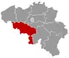
Châtelet, Belgium
Châtelet (Walloon: Tcheslet) is a municipality in Hainaut Province, Belgium. It lies on the river Sambre, in the country's Wallonia region. As of January 1, 2006, Châtelet had a total population of 35,621. The total area of the municipality is 27.03 km² which gives a population density of 1,318 inhabitants per km². It is composed of three separate entities: Châtelet, Bouffioulx and Châtelineau. Châtelet was a long established independent city prior to its fusion with the other entities.
Châtelet | |
|---|---|
 | |
 Flag  Coat of arms | |
 Châtelet Location in Belgium
Location of Châtelet in Hainaut 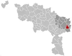 | |
| Coordinates: 50°24′N 04°31′E | |
| Country | Belgium |
| Community | French Community |
| Region | Wallonia |
| Province | Hainaut |
| Arrondissement | Charleroi |
| Government | |
| • Mayor | Daniel Vanderlick |
| • Governing party/ies | PS |
| Area | |
| • Total | 27.03 km2 (10.44 sq mi) |
| Population (2018-01-01)[1] | |
| • Total | 36,101 |
| • Density | 1,300/km2 (3,500/sq mi) |
| Postal codes | 6200 |
| Area codes | 071 |
| Website | www.chatelet.be |
History
Origins and Middle Ages
The first settlers of the site of Châtelet, dating from paleolithic times, were attracted by the ford on the river, the nearby wooded areas and flint-rich highlands. This region was continuously populated, first by Celtic, then Gallo-Roman peoples, until the Germanic invasions of the 4th and 5th century. In the 9th century, the land was likely part of emperor Louis the Pious’s estate. The first occurrence of the name Châtelet appears in a text dating from the time when its territory was given to the chapter of the Liège cathedral in the 12th century. Châtelet obtained its charter of rights in 1220, symbolized by the perron. The protection later afforded by the Prince-Bishopric of Liège made the city into an important administrative, cultural, and economic centre, which could boast four annual trade fairs and a weekly cattle market. It became one of the 23 bonne villes (main cities) of the prince-bishopric in 1655. While Châtelet's economy was dominated by artisanal guilds and trade, that of its neighbours, including Châtelineau and Bouffioulx, remained mostly agricultural.
18th century until now
The 18th century first witnessed the gradual shift of the regional economic power from Châtelet to the newly founded neighbouring city of Charleroi. This was also a time of political instability as the various powers of the day (Spain, France, Austria) fought for supremacy in this region. By the end of the century, the main economic drivers of the whole Sambre valley had become coal and heavy industry. The prosperity that came with the industrial revolution accounts for much of the population growth of the 1800s: Châtelet grew by a factor 5 in less than a century; Châtelineau grew by a factor 20 between 1811 and 1950 to more than 18,000 inhabitants. Many of the current city streets can be dated from that period. Cultural activities and artistic talent flourished as well.
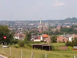
Chatelet, and, in particular, Bouffioux, became well known for the production of its potteries. Originally formed in coal-fired kilns, the works from the region became internationally sought after. Three major producers still exist in the region and continue to produce artistic, as well as useful, pottery, but on a much smaller scale. The 20th century was not kind to the region but despite having witnessed two world wars and the decline of most of its industries, Châtelet is now again a regional center for trade, culture, and educational services.
Sights
- The Saint Roch chapel, built in the Baroque style, dates from 1626. The so-called Spanish House dates from the same period.
- The Magritte walk in the center of the city features various surrealistic representations, including street lights capped with bowler hats in homage to the artist.
- Châtelet also boasts several green areas, including the Sebastopol reservation, which contains old quarries and an extensive bird population, the municipal woods (Bois Communal), with a bat-filled cave, and the municipal park, located at the heart of the city.
Events
- Since 1961, a folkloric march starting at the Saint-Roch chapel takes place every year on the Sunday following the feast of the Ascension.
Famous inhabitants
- René Magritte (1898-1967), surrealist painter , spent his youth in Châtelet
- Pierre Paulus (1881-1959), expressionist painter and designer of the rooster of the Walloon flag, was born in Châtelet
- Octave Pirmez (1832-1883), author, was born in Châtelineau
- Joel Robert, six-time motocross world champion
- Claude Barzotti, Belgian singer of Italian origin
- Claire Kerwin (1919-2005), artist who was born in Châtelet
Twin cities
References
- "Wettelijke Bevolking per gemeente op 1 januari 2018". Statbel. Retrieved 9 March 2019.
External links
| Wikimedia Commons has media related to Châtelet. |
Places adjacent to Châtelet, Belgium | |
|---|---|