Chak Peak
Chak Peak is a 2,775-metre (9,104-foot) mountain summit located in the Athabasca River valley of Jasper National Park, in the Canadian Rockies of Alberta, Canada.[2] Chak is a name derived from the Stoney language meaning "eagle".[3] Precipitation runoff from Chak Peak drains into Portal Creek and Astoria River which are both tributaries of the Athabasca River.
| Chak Peak | |
|---|---|
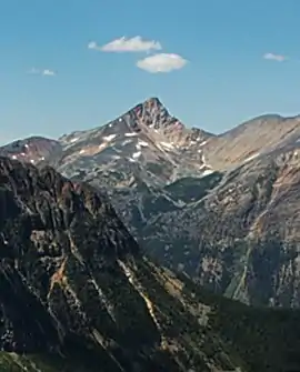 Chak Peak seen from Cavell Meadows Trail | |
| Highest point | |
| Elevation | 2,775 m (9,104 ft) [1] |
| Prominence | 235 m (771 ft) [1] |
| Parent peak | Franchère Peak 2805 m[1] |
| Listing | Mountains of Alberta |
| Coordinates | 52°42′43″N 118°07′38″W [2] |
| Geography | |
 Chak Peak Location of Chak Peak in Alberta  Chak Peak Chak Peak (Canada) | |
| Location | Jasper National Park Alberta, Canada |
| Parent range | Canadian Rockies |
| Topo map | NTS 83D/09[2] |
| Climbing | |
| First ascent | 1915 Topographical Survey[1] |
Climate
Based on the Köppen climate classification, Chak Peak is located in a subarctic climate with cold, snowy winters, and mild summers.[4] Temperatures can drop below -20 °C with wind chill factors below -30 °C.
Geology
The mountain is composed of sedimentary rock laid down during the Precambrian to Jurassic periods and pushed east and over the top of younger rock during the Laramide orogeny.[5]
See also
References
- "Chak Peak". Bivouac.com. Retrieved 2019-03-30.
- "Chak Peak". Geographical Names Data Base. Natural Resources Canada. Retrieved 2021-01-03.
- Place-names of Alberta. Ottawa: Geographic Board of Canada. 1928. p. 32.
- Peel, M. C.; Finlayson, B. L. & McMahon, T. A. (2007). "Updated world map of the Köppen−Geiger climate classification". Hydrol. Earth Syst. Sci. 11: 1633–1644. ISSN 1027-5606.
- Gadd, Ben (2008), Geology of the Rocky Mountains and Columbias