Cheek Creek Township, Montgomery County, North Carolina
Cheek Creek Township, population 628,[3] is one of eleven townships in Montgomery County, North Carolina, United States. Cheek Creek Township is 35.03 square miles (90.7 km2)[1] in size and is located in the south-central part of the county.
Cheek Creek Township, Montgomery County, North Carolina | |
|---|---|
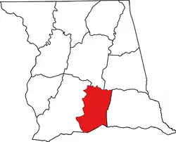 Location of Cheek Creek Township in Montgomery County | |
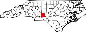 Location of Montgomery County in North Carolina | |
| Country | United States |
| State | North Carolina |
| County | Montgomery |
| Area | |
| • Total | 35.03 sq mi (90.73 km2) |
| Highest elevation [2] (northeast end north of Polly Branch) | 674 ft (205 m) |
| Lowest elevation [2] (Little River at southwest corner of township) | 188 ft (57 m) |
| Population (2010) | |
| • Total | 628[3] |
| • Density | 17.93/sq mi (6.92/km2) |
| Time zone | UTC-4 (EST) |
| • Summer (DST) | UTC-5 (EDT) |
| Area code(s) | 910 |
Geography
Cheek Creek Township is drained entirely by the Little River and its tributaries. The Little River is part of the larger Pee Dee River watershed. The northeast part of the township has a small area of the Uwharrie Mountains and the southern part has the wide floodplain of Cheek Creek.[2]
References
- "NC OneMap". www.nconemap.gov. State of North Carolina. Retrieved 13 September 2020.
- "The National Map - Service Endpoints". viewer.nationalmap.gov. US Geological Survey. Retrieved 13 September 2020.
- "Dicennial Census". data.census.gov. US Census Bureau. Retrieved 15 September 2020.
Municipalities and communities of Montgomery County, North Carolina, United States | ||
|---|---|---|
| Towns |  Montgomery County map | |
| Unincorporated communities | ||
| ||
This article is issued from Wikipedia. The text is licensed under Creative Commons - Attribution - Sharealike. Additional terms may apply for the media files.
