Chehalis River (Washington)
The Chehalis River (/ʃəˈheɪlɪs/ shə-HAY-lis)[6] is a river in Washington in the United States. It originates in several forks in southwestern Washington, flows east, then north, then west, in a large curve, before emptying into Grays Harbor, an estuary of the Pacific Ocean.
| Chehalis River | |
|---|---|
 Chehalis River Valley (left), Grays Harbor (middle distance) and Satsop River Valley (along bottom) | |
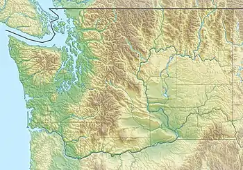
 Map of the Chehalis River watershed | |
 Mouth of the Chehalis River in Washington  Chehalis River (Washington) (the United States) | |
| Location | |
| Country | United States |
| State | Washington |
| Counties | Grays Harbor, Thurston, Lewis |
| Cities | Aberdeen, Centralia, Chehalis |
| Physical characteristics | |
| Source | |
| • location | Lewis County |
| • coordinates | 46°27′6″N 123°17′30″W[1] |
| • elevation | 1,000 ft (300 m)[2] |
| Mouth | Pacific Ocean |
• location | Grays Harbor, Aberdeen |
• coordinates | 46°57′29″N 123°50′5″W[1] |
• elevation | 0 ft (0 m)[2] |
| Length | 115 mi (185 km)[3] |
| Basin size | 2,660 sq mi (6,900 km2)[4] |
| Discharge | |
| • location | near Satsop, WA[5] |
| • average | 6,425 cu ft/s (181.9 m3/s)[5] |
| • minimum | 440 cu ft/s (12 m3/s) |
| • maximum | 47,000 cu ft/s (1,300 m3/s) |
| Discharge | |
| • location | mouth (Grays Harbor)[4] |
| • average | 11,208 cu ft/s (317.4 m3/s)[4] |
| Basin features | |
| Tributaries | |
| • right | South Fork Chehalis River, Newaukum River, Skookumchuck River, Satsop River, Wynoochee River, Wishkah River |
It was once much larger during the Ice Age when the tongue of the glacial ice sheet covering the Puget Sound terminated near Olympia and glacial runoff formed a large torrent of meltwater. This carved a large oversized valley that is much larger than the current river could have produced. The river's mouth was out near current Westport until rising sea levels at the end of the ice age flooded the broad Chehalis Valley to form a ria, known today as Grays Harbor.
Course
The Chehalis River begins at the confluence of the West Fork Chehalis River and East Fork Chehalis River, in southwestern Lewis County. From there the Chehalis flows north and east, collecting tributary streams that drain the Willapa Hills and other low mountains of southwestern Washington. The South Fork Chehalis River joins the main river a few miles west of the city of Chehalis. The Newaukum River joins the Chehalis River at Chehalis, after which the river turns north, flowing by the city of Centralia, where the Skookumchuck River joins. After Centralia, the Chehalis River flows north and west, collecting tributaries such as the Black River, which drains the Black Hills to the north, then in the Chehalis Gap collects the Satsop River and Wynoochee River, which drain the southern part of the Olympic Mountains.
The Wynoochee River joins the Chehalis near Montesano, after which the Chehalis River becomes increasingly affected by tides and widens into Grays Harbor estuary. The city of Aberdeen lies at the mouth of the Chehalis River. Just east of Aberdeen, the Wishkah River joins the Chehalis, and just west, between Aberdeen and Hoquiam, the Hoquiam River joins. At this point the river has become Grays Harbor. Before the estuary of Grays Harbor empties into the Pacific Ocean, the Humptulips River joins.

Flood history
December 3, 2007, floods
During the Great Coastal Gale of 2007, a 20-mile (32 km) stretch of Interstate 5 was closed between exits 68 and 88 because of flooding from the Chehalis River, causing the roadway to be under about 10 feet (3.0 m) of water. The recommended detour added about four hours and 280 miles (450 km).[7] It was not expected to reopen for several days.[8] However, upon breaching a dike on Dec. 5, 2007,[9] the water receded more quickly than anticipated. Amtrak train service between Portland, Oregon, and Vancouver, British Columbia, was also disrupted.[10] Washington governor Christine Gregoire declared a state of emergency on December 3.[11][12]
January 7, 2009, floods
During the January 7, 2009, Pacific Northwest storms, a 20-mile (32 km) stretch of Interstate 5 was closed between exits 68 and 88 because of flooding from the Chehalis River, causing the roadway to be under several feet of water. Since the main east/west mountain passes were also closed during this event, the flooding from the Chehalis River essentially cut off traffic to the Puget Sound area and no detour was available.
See also
References
- U.S. Geological Survey Geographic Names Information System: Chehalis River, USGS, GNIS
- Google Earth elevation for GNIS coordinates.
- Chehalis River Archived March 30, 2005, at the Wayback Machine, The Columbia Gazetteer of North America
- Overview of the Chehalis River Basin Archived October 19, 2007, at the Wayback Machine, Chehalis River Council
- Water Resource Data, Washington, 2005, USGS.
- Phillips, James W. (1971). Washington State Place Names. University of Washington Press. ISBN 0-295-95158-3.
- "Lane Of I-5 Could Reopen For Commercial Vehicles Tonight". KPTV, Associated Press. Archived from the original on 2007-12-05. Retrieved 2007-12-06.
- "I-5 near Chehalis may be shut down for days". KATU, Associated Press. Archived from the original on 2007-12-06. Retrieved 2007-12-04.
- "WSDOT crews to breach dike to help drain flood waters from I-5". KATU, Associated Press. Archived from the original on 2007-12-09. Retrieved 2007-12-06.
- "Rain floods streets; mudslides shut down Amtrak". The News Tribune. Retrieved 2007-12-06.
- "Proclamation by the Governor" (PDF) (Press release). State of Washington Office of the Governor. December 3, 2007. Archived from the original (PDF) on February 27, 2008. Retrieved 2007-12-05.
- "Proclamation by the Governor" (PDF) (Press release). State of Washington Office of the Governor. December 3, 2007. Retrieved 2017-07-11.
External links
- Chehalis River Council
- USGS Chehalis River Basin map
- USGS Chehalis River Basin schematic diagram
- U.S. Geological Survey Geographic Names Information System: East Fork Chehalis River, USGS, GNIS
- U.S. Geological Survey Geographic Names Information System: West Fork Chehalis River, USGS, GNIS
- U.S. Geological Survey Geographic Names Information System: South Fork Chehalis River, USGS, GNIS
- Interstate 5 near Chehalis shut down indefinitely
| Authority control |
|
|---|