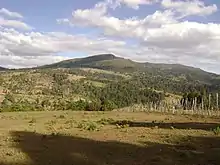
Cherangani Hills Forest
Cherangani Hills Forest (Cherangany Hills Forest) is a collection of thirteen forest reserve blocks in western Kenya, located in the Cherangani Hills on the western ridge of the East African Rift. The forested area is about 1,200 square kilometres (463 sq mi),[1] 956 square kilometres (369 sq mi) of which has been gazetted into forest reserves.[2] These forest reserves form the upper catchments of the Kerio and Nzoia and Turkwel rivers.[1]
)_(18161776001).jpg.webp)
Forest types
The three western blocks, Kapkanyar, Kapolet and Kiptaberr, are larger and more consolidated and constitute about 20% of the Cherangani Hills Forest. Most of the rest of the forests are fragmented, cut by grasslands, bushlands, and croplands.[2] The forests themselves are quite varied in composition. To the west, the lower elevations are "Aningeria-Strombosia-Drypetes" forest, grading into mixed Podocarpus latifolius forest on the higher elevations. To the east are "Juniperus–Nuxia–Podocarpus falcatus" forest, particularly on south facing slopes. On the eastern slopes these are interspersed with Podocarpus falcatus forest, much disturbed by human activities. sizeable remnants of "Juniperus–Maytenus undata–Rapanea–Hagenia" forest can be found in the high valleys. In some of the stream valleys tree ferns such as Cyathea manniana can be found as well as small patches of the bamboo Yushania alpina.[2]
Forest blocks
- Kapkanyar Forest Reserve,[3] 01°11′N 35°16′E
- Kapolet Forest Reserve,[4] 01°10′N 35°10′E
- Kiptaberr Forest Reserve,[5] 01°05′N 35°18′E
- Lelan Forest Reserve,[6] 01°17′N 35°27′E
- Embobut Forest Reserve,[7] 01°15′N 35°35′E
- Kerrer Forest Reserve,
- Kaisungurr Forest Reserve,[8] 01°03′N 35°26′E
- Toropket Forest Reserve,[9] 01°01′N 35°26′E
- Chemurokoi Forest Reserve,
- Kupkunurr Forest Reserve,
- Cheboit Forest Reserve,
- Sogotio Forest Reserve,[10] 00°56′01″N 35°32′13″E and
- Kapchemutwa Forest Reserve[11] 00°50′31″N 35°32′14″E
Conservation issues
The Cherangani Hills Forest is threatened by increased pressures from a growing local population, as well as by pressure from downstream inhabitants. The problems range from overgrazing, to conversion of the forest to cropland, to excessive use of forest products in making charcoal and providing local lumber.[12][13]
Gallery
 Environmentalist Rachel Nyakeri and Wildlife Society officials identify invasive vegetation
 Bee-keeping project to curb deforestation
 A planted woodlot of exotics which relieves collection pressure on the forest
 A tilapia fish farming project
Notes
- Kimani, Samuel Munyua (June 2011). "The Role of Geospatial Technologies in Livelihood and Natural Resources Management: PES Analysis". Baobab: A Magazine on Drylands Development and Sustainable Agriculture (62): 28–29.
- "Cherangani Hills (KE43)". BirdLife.
- Kapkanyar Forest (Approved) at GEOnet Names Server, United States National Geospatial-Intelligence Agency
- Kapolet Forest (Approved) at GEOnet Names Server, United States National Geospatial-Intelligence Agency
- Kiptaberr Forest (Approved) at GEOnet Names Server, United States National Geospatial-Intelligence Agency
- Lelan Forest (Approved) at GEOnet Names Server, United States National Geospatial-Intelligence Agency
- Embobut Forest (Approved) at GEOnet Names Server, United States National Geospatial-Intelligence Agency
- Kaisungurr Forest (Approved) at GEOnet Names Server, United States National Geospatial-Intelligence Agency
- Toropket Forest (Approved) at GEOnet Names Server, United States National Geospatial-Intelligence Agency
- Sogotio Forest (Approved) at GEOnet Names Server, United States National Geospatial-Intelligence Agency
- Kapchemutwa Forest (Approved) at GEOnet Names Server, United States National Geospatial-Intelligence Agency
- "FSP – Strengthening the Protected Area Network within the Eastern Montane Forest Hotspot of Kenya" (PDF). The GEF Trust Fund. 12 November 2009. Archived from the original (PDF) on 24 July 2010. Retrieved 9 August 2012.
- Kushner, Jacob (April 16, 2015). "The World Bank's broken promise to 'do no harm'". Los Angeles Times.