Chila Pillune
Chila Pillune (possibly from Aymara pillu crown or cord which some indigenous peoples use to tighten their hair,[2] -ni a suffix to indicate ownership, pilluni "the one with a crown" or "the one with a pillu") is a mountain in the western part of the Chila mountain range in the Andes of Peru, about 5,328 m (17,480 ft) high. It lies in the Arequipa Region, Castilla Province, Chachas District. Chila Pillune is situated west of Chila, the highest mountain of the range, northeast of Ticlla and south of Apacheta.[1]
| Chila Pillune | |
|---|---|
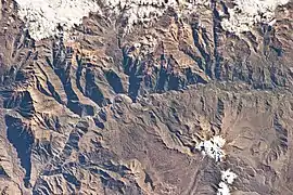 The Colca River and Chila Pillune northwest of it (upper left) as seen from the ISS | |
| Highest point | |
| Elevation | 5,400 m (17,700 ft) [1] |
| Coordinates | 15°24′26″S 72°11′16″W |
| Geography | |
 Chila Pillune Peru | |
| Location | Peru, Arequipa Region, Castilla Province |
| Parent range | Andes, Chila |
References
- escale.minedu.gob.pe - UGEL map of the Caylloma Province 1 (Arequipa Region)
- Radio San Gabriel, "Instituto Radiofonico de Promoción Aymara" (IRPA) 1993, Republicado por Instituto de las Lenguas y Literaturas Andinas-Amazónicas (ILLLA-A) 2011, Transcripción del Vocabulario de la Lengua Aymara, P. Ludovico Bertonio 1612 (Spanish-Aymara-Aymara-Spanish dictionary)
This article is issued from Wikipedia. The text is licensed under Creative Commons - Attribution - Sharealike. Additional terms may apply for the media files.