Castilla Province
Castilla Province is one of eight provinces in the Arequipa Region of Peru. It was named after Ramón Castilla.
Castilla | |
|---|---|
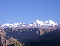 Coropuna as seen from Tipan | |
 Flag  Coat of arms | |
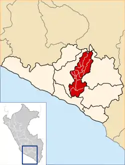 Location of Castilla in the Arequipa Region | |
| Country | Peru |
| Region | Arequipa |
| Capital | Aplao |
| Government | |
| • Mayor | Gilder Edy Medina Collado (2007) |
| Area | |
| • Total | 6,914.48 km2 (2,669.70 sq mi) |
| Population | |
| • Total | 36,568 |
| • Density | 5.3/km2 (14/sq mi) |
| UBIGEO | 0404 |
| Website | www.municipiocastilla.gob.pe |
Geography
The Chila mountain range traverses the province. One of the highest mountains of the province is Coropuna at 6,425 m (21,079 ft) above sea level. Other mountains are listed below:[1]
- Apachita
- Asiruta
- Asnu Wañusqa
- Ayri Qutu
- Challwani
- Chila
- Chinchun
- Chuqi P'unqu
- Chuqi Pirwa
- Chila (Cast.-Caylloma)
- Chila Pilluni
- Ch'illkayuq
- Ch'uwañuma
- Ikma
- Janq'u Qala
- Kimsa Chata
- Kiska P'anqa
- Kuntur
- Kuntur Qaqa
- Kunturkhacha
- Llallawi
- Minasniyuq
- Pampa Qullqa
- Puka Mawras
- Puka Mawras (Andagua)
- Puma Ranra
- Pilluni
- Phusuqu
- P'aqu Urqu
- P'isqi P'isqi
- Qallwa
- Qaqamayu
- Qinchaña
- Qullpa
- Q'illa Q'illa
- Q'illu Q'illu
- Qillqani
- Sama Q'asa
- Sani
- Sawsi
- Sukna
- Sulimana
- Sulluku Llawa
- Sunqu
- Tiklla
- Tiklla (Qaqamayu)
- Tuqlla Tuqlla
- T'iksu
- Uqi Q'asa
- Usqullu
- Wakapallqa
- Waman Quri
- Wamanripayuq
- Wanqa
- Waña Q'awa
- Waqrawiri
- Waylla Tarpuna
- Wayrani
- Wayta
- Wayta Kuntur Sinqa
- Wayllayuq
- Willkani
- Yana Mawras
- Yana Qaqa
- Yana Urqu
- Yanawara
- Yanqha
- Yuraq Q'asa
Machuqucha is one of the largest lakes of the province.[1]
Political division
The province is divided into fourteen districts which are, with its capital in parenthesis:
- Andagua (Andagua)
- Aplao (Aplao)
- Ayo (Ayo)
- Chachas (Chachas)
- Chilcaymarca (Chilcaymarca)
- Choco (Choco)
- Huancarqui (Huancarqui)
- Machaguay (Machaguay)
- Orcopampa (Orcopampa)
- Pampacolca (Pampacolca)
- Tipán (Tipán)
- Uñón (Uñón)
- Uraca (Corire)
- Viraco (Viraco)
Ethnic groups
The province is inhabited by indigenous citizens of Aymara and Quechua descent. Spanish, however, is the language which the majority of the population (79.72%) learnt to speak in childhood, 18.52% of the residents started speaking using the Quechua language and 1.51% using Aymara (2007 Peru Census).[2]
See also
Sources
- escale.minedu.gob.pe - UGEL maps of the Caylloma Province 1 and 2 (Arequipa Region)
- inei.gob.pe Archived January 27, 2013, at the Wayback Machine INEI, Peru, Censos Nacionales 2007
This article is issued from Wikipedia. The text is licensed under Creative Commons - Attribution - Sharealike. Additional terms may apply for the media files.