Clancy, Montana
Clancy is an unincorporated community and census-designated place (CDP) in Jefferson County, Montana, United States. The population was 1,661 at the 2010 census,[1] up from 1,406 in 2000. It is part of the Helena Micropolitan Statistical Area.
Clancy, Montana | |
|---|---|
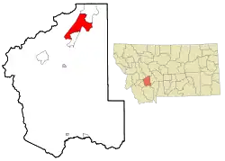 Location of Clancy, Montana | |
| Coordinates: 46°28′29″N 111°59′1″W | |
| Country | United States |
| State | Montana |
| County | Jefferson |
| Area | |
| • Total | 39.2 sq mi (101.4 km2) |
| • Land | 39.2 sq mi (101.4 km2) |
| • Water | 0.0 sq mi (0.0 km2) |
| Elevation | 4,242 ft (1,293 m) |
| Population (2010) | |
| • Total | 1,661 |
| • Density | 42/sq mi (16.4/km2) |
| Time zone | UTC-7 (Mountain (MST)) |
| • Summer (DST) | UTC-6 (MDT) |
| ZIP code | 59634 |
| Area code(s) | 406 |
| FIPS code | 30-15100 |
| GNIS feature ID | 0800597 |
Geography
Clancy is located in northern Jefferson County at 46°28′29″N 111°59′1″W (46.474638, -111.983497),[2] in the valley of Prickly Pear Creek where it is joined by Clancy Creek. Clancy is bordered to the north by Montana City and to the south by Jefferson City. Interstate 15 passes through Clancy, with access from Exit 182. I-15 leads north 12 miles (19 km) to Helena, the state capital, and south 18 miles (29 km) to Boulder, the Jefferson county seat.
According to the United States Census Bureau, the CDP has a total area of 39.2 square miles (101.4 km2), all land.[1] The CDP includes the community of Alhambra, 1 mile (1.6 km) south of Clancy proper.
Climate
According to the Köppen Climate Classification system, Clancy has a semi-arid climate, abbreviated "BSk" on climate maps.[3]
Economy
Most people who live in and around Clancy work in Montana's capital city of Helena, which is a short drive north on I-15. Two restaurants operate in Clancy, the Legal Tender[4] and Chubby's Bar and Grill.[5] Elkhorn Health and Rehabilitation runs a small nursing home in the community, and Clancy Elementary School, a K-8 institution, employs more than thirty people.[6]
Demographics
As of the census[7] of 2010, there were 1,661 people, an 18% increase from the 2000 census. In 2000 there were 1,406 people, in 540 households, and 428 families residing in the CDP. The population density was 39.3 people per square mile (15.2/km2). There were 559 housing units at an average density of 15.6 per square mile (6.0/km2). The racial makeup of the CDP was 96.23% White, 0.14% African American, 0.92% Native American, 0.57% Asian, 0.43% from other races, and 1.71% from two or more races. Hispanic or Latino of any race were 1.99% of the population.
There were 540 households, out of which 36.7% had children under the age of 18 living with them, 70.4% were married couples living together, 6.1% had a female householder with no husband present, and 20.6% were non-families. 15.7% of all households were made up of individuals, and 5.4% had someone living alone who was 65 years of age or older. The average household size was 2.60 and the average family size was 2.93.
In the CDP, the population was spread out, with 26.3% under the age of 18, 5.2% from 18 to 24, 26.3% from 25 to 44, 34.4% from 45 to 64, and 7.8% who were 65 years of age or older. The median age was 42 years. For every 100 females, there were 103.2 males. For every 100 females age 18 and over, there were 103.5 males.
The median income for a household in the CDP was $52,938, and the median income for a family was $59,766. Males had a median income of $38,750 versus $24,091 for females. The per capita income for the CDP was $23,492. About 2.0% of families and 3.3% of the population were below the poverty line, including 3.1% of those under age 18 and 3.9% of those age 65 or over.
References
- "Geographic Identifiers: 2010 Census Summary File 1 (G001): Clancy CDP, Montana". American Factfinder. U.S. Census Bureau. Archived from the original on February 13, 2020. Retrieved August 21, 2018.
- "US Gazetteer files: 2010, 2000, and 1990". United States Census Bureau. 2011-02-12. Retrieved 2011-04-23.
- "Clancy, Montana Köppen Climate Classification (Weatherbase)". Weatherbase.
- "Legal Tender Pub & Bistro - Home". www.legaltendermt.com.
- "Chubbys Bar & Grill". www.facebook.com.
- "Clancy School | Quality K-8 Education in, Clancy Montana".
- "U.S. Census website". United States Census Bureau. Retrieved 2008-01-31.
Municipalities and communities of Jefferson County, Montana, United States | ||
|---|---|---|
| Towns | 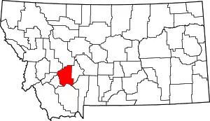 Jefferson County map | |
| CDPs | ||
| Unincorporated communities | ||
| ||
| Authority control |
|---|