Clarendon County, New South Wales

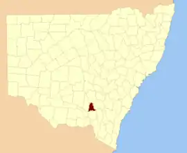
Clarendon County is one of the 141 Cadastral divisions of New South Wales. It contains the towns of Gundagai, Junee and Bethungra. The Murrumbidgee River is the boundary to the south.

Clarendon
New South Wales
Location in New South Wales
Lands administrative divisions around Clarendon:
Bourke Bland Bland
Bourke Clarendon Harden
Mitchell Wynyard Buccleuch

Clarendon County was named in honour of George William Frederick Villiers, 4th Earl Clarendon (1800-1870).[1]

The Murrumbidgee River at Gundagai; the boundary between Clarendon and Wynyard

Parishes within this county

A full list of parishes found within this county; their current LGA and mapping coordinates to the approximate centre of each location is as follows:

ParishLGACoordinates
BethungraJunee Shire Council34°43′54″S 147°50′04″E
BildaJunee Shire Council35°04′54″S 147°39′04″E
BillabungJunee Shire Council34°47′54″S 147°48′04″E
BoreeJunee Shire Council34°50′54″S 147°39′04″E
BulganCity of Wagga Wagga34°57′54″S 147°20′04″E
ButeJunee Shire Council34°35′54″S 147°46′04″E
ClarisJunee Shire Council34°59′54″S 147°40′04″E
CoobaJunee Shire Council34°55′54″S 147°52′04″E
EunanoreenyaCity of Wagga Wagga35°03′54″S 147°29′04″E
EurongillyJunee Shire Council34°55′54″S 147°45′04″E
GobbagombalinCity of Wagga Wagga35°02′54″S 147°18′04″E
GwynneJunee Shire Council34°47′54″S 147°30′04″E
HoulaghanJunee Shire Council34°43′40″S 147°32′43″E
HurleyJunee Shire Council34°36′54″S 147°41′04″E
IronbongJunee Shire Council34°44′54″S 147°45′04″E
IvorJunee Shire Council34°44′54″S 147°40′04″E
JeralgambethJunee Shire Council34°59′54″S 147°35′04″E
JuneeJunee Shire Council34°47′54″S 147°33′04″E
KimoCootamundra-Gundagai Regional Council35°02′54″S 148°00′04″E
MaleboJunee Shire Council34°55′54″S 147°23′04″E
MarorJunee Shire Council34°50′54″S 147°28′04″E
MerrybundinahJunee Shire Council34°51′54″S 147°48′04″E
Mitta MittaJunee Shire Council34°51′54″S 147°54′04″E
NangusCootamundra-Gundagai Regional Council35°00′54″S 147°57′04″E
North GundagaiCootamundra-Gundagai Regional Council35°00′54″S 148°04′04″E
North Wagga WaggaCity of Wagga Wagga35°03′54″S 147°23′04″E
OuraCity of Wagga Wagga35°03′54″S 147°33′04″E
SebastopolTemora Shire Council34°35′54″S 147°34′04″E
South JuneeJunee Shire Council34°53′54″S 147°31′04″E
TenandraJunee Shire Council34°59′54″S 147°50′04″E
TrevethinJunee Shire Council34°40′54″S 147°40′04″E
UlandraJunee Shire Council34°45′54″S 147°54′04″E
WallaceCity of Wagga Wagga34°57′54″S 147°28′04″E
WantabadgeryJunee Shire Council34°59′54″S 147°45′04″E
WantioolJunee Shire Council34°54′54″S 147°39′04″E
Warre WarralJunee Shire Council34°38′54″S 147°32′04″E

References

  1. "Clarendon County". Geographical Names Register (GNR) of NSW. Geographical Names Board of New South Wales.
This article is issued from Wikipedia. The text is licensed under Creative Commons - Attribution - Sharealike. Additional terms may apply for the media files.