Mitchell County, New South Wales

Mitchell County is one of the 141 Cadastral divisions of New South Wales. It contains the town of Collingullie. The Murrumbidgee River is the northern boundary.

Mitchell
New South Wales
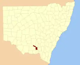
Location in New South Wales
Lands administrative divisions around Mitchell:
Cooper Bourke Clarendon
Urana Mitchell Wynyard
Urana Hume Goulburn

Mitchell County is named in honour of the Surveyor-General Sir Thomas Livingstone Mitchell (1792-1855).[1]

Parishes within this county

A full list of parishes found within this county; their current LGA and mapping coordinates to the approximate centre of each location is as follows:

ParishLGACoordinates
ArajoelCity of Wagga Wagga35°01′54″S 146°50′04″E
AshcroftLockhart Shire Council35°13′54″S 146°53′04″E
Berry JerryCity of Wagga Wagga35°02′54″S 147°00′04″E
BirregoNarrandera Shire Council34°56′54″S 146°35′04″E
BrewarrinaNarrandera Shire Council34°51′54″S 146°45′04″E
BuckinbongNarrandera Shire Council34°51′54″S 146°41′04″E
BulgaryCity of Wagga Wagga35°00′54″S 146°57′04″E
BullenbungLockhart Shire Council35°07′54″S 147°00′04″E
BurkeLockhart Shire Council35°17′54″S 147°10′04″E
BurrandanaCity of Wagga Wagga35°23′54″S 147°22′04″E
Coffin RockCity of Wagga Wagga35°21′54″S 147°18′04″E
CorobimillaNarrandera Shire Council34°52′54″S 146°23′04″E
CoxLockhart Shire Council35°22′54″S 147°08′04″E
CuddellNarrandera Shire Council34°48′54″S 146°24′04″E
EdgehillLockhart Shire Council35°28′54″S 147°01′04″E
FaithfullNarrandera Shire Council34°57′54″S 146°41′04″E
GillenbahNarrandera Shire Council34°44′54″S 146°30′04″E
GobbagaulaNarrandera Shire Council34°51′54″S 146°36′04″E
GrubbenLockhart Shire Council35°24′54″S 147°00′04″E
Hanging RockLockhart Shire Council35°15′54″S 147°03′04″E
LeitchLockhart Shire Council35°14′54″S 147°07′04″E
MacleanCity of Wagga Wagga35°26′54″S 147°15′04″E
MangoplahCity of Wagga Wagga35°22′54″S 147°15′04″E
MilbrulongLockhart Shire Council35°18′54″S 146°55′04″E
MimosaNarrandera Shire Council35°00′54″S 146°46′04″E
MundawadderyLockhart Shire Council35°23′54″S 146°53′04″E
MundowyCity of Wagga Wagga35°06′54″S 147°06′04″E
OsborneCity of Wagga Wagga35°07′54″S 146°54′04″E
PearsonCity of Wagga Wagga35°15′54″S 147°11′04″E
PulletopCity of Wagga Wagga35°26′54″S 147°22′04″E
Sandy CreekCity of Wagga Wagga35°15′54″S 147°18′04″E
TootoolLockhart Shire Council35°14′54″S 147°00′04″E
UranquintyCity of Wagga Wagga35°06′54″S 147°15′04″E
VincentLockhart Shire Council35°20′54″S 147°00′04″E
WauberrimaCity of Wagga Wagga34°56′54″S 146°51′04″E
WestbyCity of Wagga Wagga35°26′54″S 147°27′04″E
WoodNarrandera Shire Council34°52′54″S 146°30′04″E
YarabeeNarrandera Shire Council34°44′54″S 146°26′04″E
YarragundryCity of Wagga Wagga35°08′54″S 147°12′04″E
YerongLockhart Shire Council35°24′54″S 147°05′04″E

References

  1. "Mitchell County". Geographical Names Register (GNR) of NSW. Geographical Names Board of New South Wales.
This article is issued from Wikipedia. The text is licensed under Creative Commons - Attribution - Sharealike. Additional terms may apply for the media files.