Clark Fork, Idaho
Clark Fork is a city in Bonner County, Idaho. The population was 536 at the 2010 census.
Clark Fork, Idaho | |
|---|---|
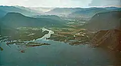 Clark Fork (located to the left/north) of the Clark Fork River, which runs down the middle | |
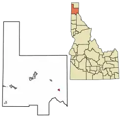 Location of Clark Fork in Bonner County, Idaho. | |
| Coordinates: 48°8′50″N 116°10′42″W | |
| Country | United States |
| State | Idaho |
| County | Bonner |
| Area | |
| • Total | 0.98 sq mi (2.55 km2) |
| • Land | 0.98 sq mi (2.55 km2) |
| • Water | 0.00 sq mi (0.00 km2) |
| Elevation | 2,090 ft (640 m) |
| Population | |
| • Total | 536 |
| • Estimate (2019)[3] | 579 |
| • Density | 587.82/sq mi (226.96/km2) |
| Time zone | UTC-8 (Pacific (PST)) |
| • Summer (DST) | UTC-7 (PDT) |
| ZIP code | 83811 |
| Area code(s) | 208, 986 |
| FIPS code | 16-14950 |
| GNIS feature ID | 0396290 |
Geography
Clark Fork is located at 48°8′50″N 116°10′42″W (48.147180, -116.178270),[4] at an elevation of 2,090 feet (637 m) above sea level. According to the United States Census Bureau, the city has a total area of 0.92 square miles (2.38 km2), all of it land.[5]
Climate
This climatic region is typified by large seasonal temperature differences, with warm to hot (and often humid) summers and cold (sometimes severely cold) winters. According to the Köppen Climate Classification system, Clark Fork has a humid continental climate, abbreviated "Dfb" on climate maps.[6]
Demographics
| Historical population | |||
|---|---|---|---|
| Census | Pop. | %± | |
| 1920 | 325 | — | |
| 1930 | 432 | 32.9% | |
| 1940 | 430 | −0.5% | |
| 1950 | 387 | −10.0% | |
| 1960 | 452 | 16.8% | |
| 1970 | 367 | −18.8% | |
| 1980 | 449 | 22.3% | |
| 1990 | 448 | −0.2% | |
| 2000 | 530 | 18.3% | |
| 2010 | 536 | 1.1% | |
| 2019 (est.) | 579 | [3] | 8.0% |
| U.S. Decennial Census[7] | |||
2010 census
As of the census[2] of 2010, there were 536 people, 260 households, and 138 families living in the city. The population density was 582.6 inhabitants per square mile (224.9/km2). There were 308 housing units at an average density of 334.8 per square mile (129.3/km2). The racial makeup of the city was 95.5% White, 0.7% Native American, 0.6% Asian, 0.6% from other races, and 2.6% from two or more races. Hispanic or Latino of any race were 0.9% of the population.
There were 260 households, of which 24.6% had children under the age of 18 living with them, 40.4% were married couples living together, 7.7% had a female householder with no husband present, 5.0% had a male householder with no wife present, and 46.9% were non-families. 41.9% of all households were made up of individuals, and 19.2% had someone living alone who was 65 years of age or older. The average household size was 2.06 and the average family size was 2.87.
The median age in the city was 45.5 years. 21.6% of residents were under the age of 18; 7.2% were between the ages of 18 and 24; 19.8% were from 25 to 44; 32.5% were from 45 to 64; and 18.8% were 65 years of age or older. The gender makeup of the city was 50.6% male and 49.4% female.
2000 census
As of the census[8] of 2000, there were 530 people, 238 households, and 138 families living in the city. The population density was 538.8 people per square mile (208.8/km2). There were 286 housing units at an average density of 290.7 per square mile (112.7/km2). The racial makeup of the city was 93.96% White, 0.57% African American, 1.32% Native American, 0.19% Asian, 1.70% from other races, and 2.26% from two or more races. Hispanic or Latino of any race were 3.02% of the population.
There were 238 households, out of which 24.4% had children under the age of 18 living with them, 47.5% were married couples living together, 8.0% had a female householder with no husband present, and 42.0% were non-families. 37.4% of all households were made up of individuals, and 16.4% had someone living alone who was 65 years of age or older. The average household size was 2.22 and the average family size was 2.94.
In the city, the population was spread out, with 24.7% under the age of 18, 4.9% from 18 to 24, 28.3% from 25 to 44, 24.0% from 45 to 64, and 18.1% who were 65 years of age or older. The median age was 40 years. For every 100 females, there were 101.5 males. For every 100 females age 18 and over, there were 95.6 males.
The median income for a household in the city was $22,031, and the median income for a family was $28,472. Males had a median income of $28,036 versus $21,042 for females. The per capita income for the city was $13,979. About 15.3% of families and 20.8% of the population were below the poverty line, including 19.0% of those under age 18 and 20.2% of those age 65 or over.
Notable people
- Ron Heller (born 1963), former NFL tight end
- Compton I. White (1877–1956), eight-term congressman from Idaho
- Compton I. White, Jr., (1920–1998), two-term congressman from Idaho
See also
References
- "2019 U.S. Gazetteer Files". United States Census Bureau. Retrieved July 9, 2020.
- "U.S. Census website". United States Census Bureau. Retrieved 2012-12-18.
- "Population and Housing Unit Estimates". United States Census Bureau. May 24, 2020. Retrieved May 27, 2020.
- "US Gazetteer files: 2010, 2000, and 1990". United States Census Bureau. 2011-02-12. Retrieved 2011-04-23.
- "US Gazetteer files 2010". United States Census Bureau. Archived from the original on 2012-01-25. Retrieved 2012-12-18.
- Climate Summary for Clark Fork, Idaho
- "Census of Population and Housing". Census.gov. Retrieved June 4, 2015.
- "U.S. Census website". United States Census Bureau. Retrieved 2008-01-31.
External links
![]() Media related to Clark Fork, Idaho at Wikimedia Commons
Media related to Clark Fork, Idaho at Wikimedia Commons
Municipalities and communities of Bonner County, Idaho, United States | ||
|---|---|---|
| Cities | Map of Idaho highlighting Bonner County | |
| CDP | ||
| Unincorporated communities | ||
| ||
| Authority control |
|---|