Clarkefield, Victoria
Clarkefield (/ˈklɑːrkfiːld/) is a town in Victoria, Australia, 46 kilometres (29 mi) northwest of Melbourne's central business district. Its local government area is the City of Hume[2] and Shire of Macedon Ranges. At the 2016 Census, Clarkefield had a population of 320.
| Clarkefield Victoria | |||||||||||||||
|---|---|---|---|---|---|---|---|---|---|---|---|---|---|---|---|
 Station Street | |||||||||||||||
 Clarkefield | |||||||||||||||
| Coordinates | 37°29′S 144°45′E | ||||||||||||||
| Population | 320 (2016 census)[1] | ||||||||||||||
| Postcode(s) | 3430[2] | ||||||||||||||
| Elevation | 308 m (1,010 ft) | ||||||||||||||
| Location | |||||||||||||||
| LGA(s) | |||||||||||||||
| County | Bourke | ||||||||||||||
| State electorate(s) | |||||||||||||||
| Federal Division(s) | McEwen | ||||||||||||||
| |||||||||||||||
The Post Office opened on 1 January 1862 and was known as Lancefield Road until 1881, Lancefield Junction until 1926 and closed in 1982.[3]
Clarkefield was occupied as pastoral run, and it was named after the pastoralist, Sir William Clarke. The Clarkefield hotel and stables were established in 1857 and are now listed as heritage properties. The first school opened here in 1890.[4]
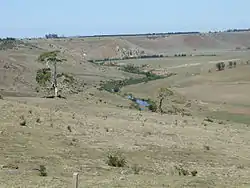
Jacksons Creek, a tributary of the Maribyrnong river at Clarkefield
See also
- Shire of Bulla - the former local government area of which Clarkefield was a part
- Shire of Romsey - the former local government area of which Clarkefield was a part
- Clarkefield railway station, Victoria
References
- Australian Bureau of Statistics (27 June 2017). "Clarkefield (State Suburb)". 2016 Census QuickStats. Retrieved 3 July 2017.

- "Postcodes within Hume City Council". Hume City Council. Archived from the original on 17 November 2007. Retrieved 13 January 2008.
- Premier Postal History. "Post Office List". Retrieved 11 April 2008.
- "Clarkefield and Monegeeta". Victorian Places.
This article is issued from Wikipedia. The text is licensed under Creative Commons - Attribution - Sharealike. Additional terms may apply for the media files.