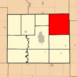
Clay Township, Adair County, Missouri
Clay Township is one of ten townships in Adair County, Missouri, United States. As of the 2010 census, its population was 626.[3] It is named in honor of Kentucky politician Henry Clay.[4]
Clay Township, Missouri | |
|---|---|
 | |
| Coordinates: 40°16′47″N 092°26′25″W | |
| Country | United States |
| State | Missouri |
| County | Adair |
| Area | |
| • Total | 79.62 sq mi (206.21 km2) |
| • Land | 79.58 sq mi (206.10 km2) |
| • Water | 0.04 sq mi (0.10 km2) 0.05% |
| Elevation | 935 ft (285 m) |
| Population (2010) | |
| • Total | 626 |
| • Density | 8/sq mi (3.0/km2) |
| FIPS code | 29-14248[2] |
| GNIS feature ID | 0766211 |
Geography
Clay Township covers an area of 79.6 square miles (206.2 km2) and contains no incorporated settlements. It contains one cemetery, Richardson.
The streams of Bee Branch, Cottonwood Fork, Floyd Creek and Willow Branch run through this township.
References
- "US Board on Geographic Names". United States Geological Survey. 2007-10-25. Retrieved 2008-01-31.
- "U.S. Census website". United States Census Bureau. Retrieved 2008-01-31.
- "Geographic Identifiers: 2010 Demographic Profile Data (G001): Clay township, Adair County, Missouri". U.S. Census Bureau, American Factfinder. Archived from the original on February 12, 2020. Retrieved June 19, 2013.
- Violette, E. M. (1911). History of Adair County. The Denslow History Company. pp. 39.
External links
Municipalities and communities of Adair County, Missouri, United States | ||
|---|---|---|
| Cities | 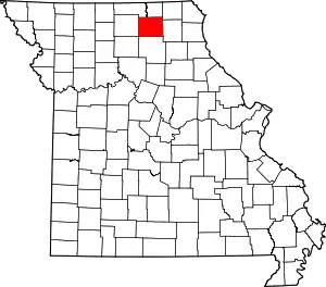 Map of Missouri highlighting Adair County | |
| Villages | ||
| Townships | ||
| Unincorporated communities | ||
| Ghost towns | ||
| Footnotes | ‡This populated place also has portions in an adjacent county or counties | |
| ||
This article is issued from Wikipedia. The text is licensed under Creative Commons - Attribution - Sharealike. Additional terms may apply for the media files.
