Cloyne, Ontario
Cloyne is a small village in the township of Addington Highlands, Lennox and Addington County, Ontario, Canada. It is located on Ontario Highway 41 about 20 kilometres (12 mi) by road north of Kaladar at the crossroads of Highway 41 with Ontario Highway 7, with the settlements of Bishop Corners and Northbrook in between, and 43 kilometres (27 mi) by road south of Denbigh, with the settlements of Ferguson Corners and Vennachar Junction in between.
Cloyne | |
|---|---|
 | |
| Etymology: After the town of the same name in Ireland | |
 Cloyne Location of Cloyne in Ontario | |
| Coordinates: 44°48′58″N 77°11′08″W | |
| Country | Canada |
| Province | Ontario |
| County | Lennox and Addington |
| Township | Addington Highlands |
| Elevation | 280 m (920 ft) |
| Time zone | UTC-5 (Eastern Time Zone) |
| • Summer (DST) | UTC-4 (Eastern Time Zone) |
| Postal code | K0H 1K0 |
| Area code(s) | 613 / 343 |
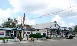
The village offers a number of services for residents, snowmobilers, cottagers and campers, particularly those visiting Bon Echo Provincial Park to the north on Highway 41. There are also number of small shops, providing townspeople and visitors access to groceries, antiques, chainsaw carvings,[1] hardware supplies, gas, and hunting and fishing gear. Cloyne is also home to the North Addington Education Centre[2] and a Pioneer Museum.[3] The northern end of the village features an oversized wooden white lawnchair, which is able to comfortably seat well over a dozen tourists for photograph opportunities.
References
- "Wolf Creek Carvings". Wolf Creek Carvings. 2011. Retrieved 2011-09-26.
- "North Addington Education Centre". Limestone District School Board. 2009. Retrieved 2010-03-04.
- "Pioneer Museum". Cloyne & District Historical Society. Retrieved 2010-03-04.
- "Cloyne". Geographical Names Data Base. Natural Resources Canada. Retrieved 2010-03-04.
- "Toporama - Topographic Map Sheet 31C14". Atlas of Canada. Natural Resources Canada. Archived from the original on 2010-08-31. Retrieved 2010-03-04.
