Coaticook
Coaticook (English: /koʊˈætɪkʊk/)[5] is a town on the Coaticook River in southeastern Quebec, Canada. It is the seat of the Coaticook Regional County Municipality, and its southern border is also the Canada–United States border.
Coaticook | |
|---|---|
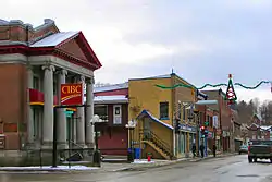 Main Street | |
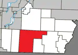 Location within Coaticook RCM. | |
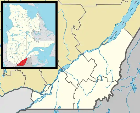 Coaticook Location in southern Quebec. | |
| Coordinates: 45°08′N 71°48′W[1] | |
| Country | |
| Province | |
| Region | Estrie |
| RCM | Coaticook |
| Settled | 1820s |
| Constituted | December 30, 1998 |
| Government | |
| • Mayor | Simon Madore |
| • Federal riding | Compton—Stanstead |
| • Prov. riding | Saint-François |
| Area | |
| • Total | 222.73 km2 (86.00 sq mi) |
| • Land | 219.51 km2 (84.75 sq mi) |
| Population (2016)[4] | |
| • Total | 8,698 |
| • Density | 39.6/km2 (103/sq mi) |
| • Pop 2011-2016 | |
| • Dwellings | 3,956 |
| Time zone | UTC−5 (EST) |
| • Summer (DST) | UTC−4 (EDT) |
| Postal code(s) | J1A |
| Area code(s) | 819 |
| Highways | |
| Website | www |
In addition to the primary community of Coaticook, smaller communities that are now within the municipal boundaries include Baldwin's Mills, Barnston, Ladd's Mills and Stanhope, the last of which was a separate community in the 1890s and used to have the small private Stanhope Airport.
Name
The municipality is named after the Coaticook River. The name “Coaticook” is of Abenaki origin, deriving from the term “koatikeku”, which means “where the river is bordered by white pines”.[6]
History
The place was founded in 1818. Richard Baldwin Senior, from Barnston Pinacle cleared a parcel of land where later the City Hall was built. Richard Baldwin son, built the first permanent residence at this place. The area of the Townships of Barnston and Barford was settled in the 1820s and 1830s by British Loyalists and US Americans, mainly from New England States.[7][8][9] The municipality was finally incorporated in 1864. Following the merger of the municipalities of Barnston Township and Barford Township on December 12, 1998, the surface area of the newly created municipality increased considerably. Today, Coaticook extends over a total land area of 218.89 square kilometres and the 108 animal farms within its territory, including 66 dairy farms, make it one of Quebec's major milk producers.[10][11] Coaticook is dubbed the Pearl of the Eastern Townships.
Demographics
Population
| Canada census – Coaticook community profile | |||
|---|---|---|---|
| 2016 | 2011 | 2006 | |
| Population: | 8,698 (-6.0% from 2011) | 9,255 (+0.6% from 2006) | 9,204 (+2.4% from 2001) |
| Land area: | 219.51 km2 (84.75 sq mi) | 218.57 km2 (84.39 sq mi) | 218.55 km2 (84.38 sq mi) |
| Population density: | 39.6/km2 (103/sq mi) | 42.3/km2 (110/sq mi) | 42.1/km2 (109/sq mi) |
| Median age: | 46.5 (M: 44.7, F: 48.0) | 44.1 (M: 42.9, F: 45.4) | 41.0 (M: 40.1, F: 41.9) |
| Total private dwellings: | 3,956 | 4,208 | 3978 |
| Median household income: | $50,677 | $43,230 | $42,647 |
| Notes: Counts have been adjusted to reflect 2001 Census boundaries. Population in 1996: 6,653[12] (+0.2% from 1991) - Population in 1991: 6,637[12] – References: 2016[4] 2011[3] 2006[13] earlier[14] | |||
Mother tongue:[15]
- English as first language: 4.5%
- French as first language: 95.1%
- English and French as first language: 0.3%
- Other as first language: 4.6%
Cemeteries
Cemeteries in or near Coaticook include Mount Forest Cemetery,[16] Saint Edmond Cemetery,[17][18] St-Luc and St-Wilfrid-de-Barnston.
Climate
| Climate data for Coaticook, Quebec | |||||||||||||
|---|---|---|---|---|---|---|---|---|---|---|---|---|---|
| Month | Jan | Feb | Mar | Apr | May | Jun | Jul | Aug | Sep | Oct | Nov | Dec | Year |
| Record high °C (°F) | 17.8 (64.0) |
17.0 (62.6) |
24.5 (76.1) |
29.5 (85.1) |
31.7 (89.1) |
33.3 (91.9) |
35.0 (95.0) |
34.4 (93.9) |
32.2 (90.0) |
28.9 (84.0) |
25.0 (77.0) |
17.8 (64.0) |
35.0 (95.0) |
| Average high °C (°F) | −5.1 (22.8) |
−2.8 (27.0) |
2.4 (36.3) |
10.4 (50.7) |
17.6 (63.7) |
22.4 (72.3) |
24.6 (76.3) |
23.6 (74.5) |
19.1 (66.4) |
11.8 (53.2) |
5.0 (41.0) |
−1.9 (28.6) |
10.6 (51.1) |
| Daily mean °C (°F) | −9.8 (14.4) |
−7.9 (17.8) |
−2.5 (27.5) |
5.3 (41.5) |
12.0 (53.6) |
17.0 (62.6) |
19.4 (66.9) |
18.4 (65.1) |
14.1 (57.4) |
7.4 (45.3) |
1.3 (34.3) |
−6.0 (21.2) |
5.7 (42.3) |
| Average low °C (°F) | −14.5 (5.9) |
−12.9 (8.8) |
−7.3 (18.9) |
0.2 (32.4) |
6.3 (43.3) |
11.6 (52.9) |
14.1 (57.4) |
13.2 (55.8) |
9.0 (48.2) |
2.9 (37.2) |
−2.5 (27.5) |
−10 (14) |
0.8 (33.4) |
| Record low °C (°F) | −41.7 (−43.1) |
−36.1 (−33.0) |
−29.4 (−20.9) |
−20.0 (−4.0) |
−7.8 (18.0) |
−2.2 (28.0) |
−1.1 (30.0) |
−1.1 (30.0) |
−5.6 (21.9) |
−10.6 (12.9) |
−25.0 (−13.0) |
−36.1 (−33.0) |
−41.7 (−43.1) |
| Average precipitation mm (inches) | 80.9 (3.19) |
69.8 (2.75) |
76.3 (3.00) |
81.2 (3.20) |
101.1 (3.98) |
124.7 (4.91) |
116.1 (4.57) |
128.9 (5.07) |
96.5 (3.80) |
104.8 (4.13) |
96.9 (3.81) |
98.8 (3.89) |
1,176 (46.30) |
| Average rainfall mm (inches) | 22.2 (0.87) |
18.0 (0.71) |
29.6 (1.17) |
67.9 (2.67) |
100.1 (3.94) |
124.7 (4.91) |
116.1 (4.57) |
128.9 (5.07) |
96.5 (3.80) |
100.2 (3.94) |
70.7 (2.78) |
33.6 (1.32) |
908.6 (35.77) |
| Average snowfall cm (inches) | 58.7 (23.1) |
51.9 (20.4) |
46.7 (18.4) |
14.1 (5.6) |
1.0 (0.4) |
0.0 (0.0) |
0.0 (0.0) |
0.0 (0.0) |
0.0 (0.0) |
4.6 (1.8) |
26.2 (10.3) |
65.2 (25.7) |
268.3 (105.6) |
| Source: Environment Canada[19] | |||||||||||||
Sports
Coaticook is home to the Coaticook Big Bill of the Ligue de Baseball Senior Élite du Québec, which play their home games in Julien Morin Stadium.
Gallery
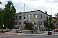 Coaticook city hall.
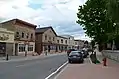 Child street in 2014.
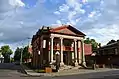 Eastern Townships Bank, Main street.
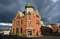 Coaticook post office.
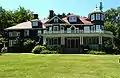 Beaulne House in Coaticook.
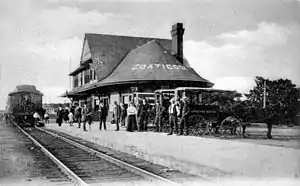 Railroad station in Coaticook.
References
- Reference number 351657 of the Commission de toponymie du Québec (in French)
- "Coaticook". Répertoire des municipalités (in French). Ministère des Affaires municipales, des Régions et de l'Occupation du territoire. Archived from the original on 2011-12-27. Retrieved 2012-01-16.
- "2011 Community Profiles". 2011 Canadian Census. Statistics Canada. July 5, 2013. Retrieved 2014-01-28.
- "2016 Community Profiles". 2016 Canadian Census. Statistics Canada. February 21, 2017. Retrieved 2017-11-29.
- The Canadian Press (2017), The Canadian Press Stylebook (18th ed.), Toronto: The Canadian Press
- A Look at Origins and Geography, virtualmuseum.ca
- Historical highlights of the region, tourismecoaticook.ca
- Heritage in motion, magazinecontinuite.com
- Great Pioneer Builders, virtualmuseum.ca
- Coaticook Bridging town and country, circuitsdecouvertecoaticook.org
- Coaticook, baladodecouverte.com
- "Electronic Area Profiles". Canada 1996 Census. Statistics Canada. Retrieved 2014-01-28.
- "2006 Community Profiles". 2006 Canadian Census. Statistics Canada. March 30, 2011. Retrieved 2012-01-16.
- "2001 Community Profiles". 2001 Canadian Census. Statistics Canada. February 17, 2012.
- "Coaticook community profile". 2016 Census data. Statistics Canada. Retrieved 2017-11-29.
- "Mount Forest Cemetery, Coaticook, Stanstead County, Quebec". interment.net. Retrieved 2009-11-08.
- "Liste des cimetières du diocèse". Cimetière Saint-Michel-de-Sherbrooke (in French). Retrieved 2009-11-08.
- "Saint Edmond Cemetery, Coaticook, Stanstead County, Quebec". interment.net. Retrieved 2009-11-08.
- "Coaticook, Quebec Climate". Canadian Climate Normals 1981–2010 (in English and French). Environment Canada. Retrieved July 16, 2015.
External links
| Wikimedia Commons has media related to Coaticook. |
- (in French) Ville de Coaticook
Adjacent Municipal Subdivisions | |
|---|---|
| Cities | |
|---|---|
| Municipalities | |
| Townships | |
| Communities | |
| |
| Authority control |
|---|