Colorado State Highway 35
State Highway 35 (SH 35) is an unsigned state route in the city of Denver, Colorado. It is 1.317 miles (2.120 km) long. Its southern end is in the vicinity of Interstate 70 (I-70) and its northern end is 53rd Place. An expansion was planned but funding has not materialized.
| State Highway 35 | ||||
|---|---|---|---|---|
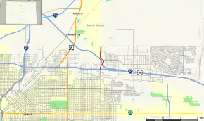 Map of County and City of Denver in north central Colorado with SH 35 highlighted in red | ||||
| Route information | ||||
| Maintained by CDOT | ||||
| Length | 1 mi[1] (2 km) | |||
| Existed | 1972[2]–present | |||
| Major junctions | ||||
| South end | 35th Avenue in Denver | |||
| North end | 53rd Place in Denver | |||
| Location | ||||
| Counties | Denver | |||
| Highway system | ||||
Colorado State Highways
| ||||
Route description
The route begins as Quebec Street near I-70. North of I-70, it becomes Northfield Quebec Street. It crosses Sand Creek and intersects I-270 and Northfield Boulevard; the interchanges overlap one another.[2] The route then continues as Quebec Street, intersects 52nd Place and ends at 53rd Place, but Quebec Street continues northward towards Commerce City.[3]
History
The route was established in 1972 as a road to Stapleton International Airport (now closed). It was planned to be extended in several locations, but it remains a short highway.[2] Government records from the 1970s indicate that the route would have run all the way from the intersection of Quebec St. and Hampden Avenue north to I-80S (now I-76), southwest of Barr Lake, but construction never began, even though the project was still listed in transportation plans until the late 1990s.[2]
The route's southern end was at the Stapleton terminal access road from 1972 to 2000, when it was moved up to I-70. From 1972–1977 the northern end of the highway ended at I-70, then moved to 56th Ave, and then to I-270 in 1988 before ending around 53rd Place in the mid-1990s.[2]
Future
Because of congestion in the areas around Quebec Street an extension of SH 35 into a major highway in the eastern metropolitan Denver area has been proposed. In theory, it would be useful to alleviate traffic jams in the Quebec St. area.[2]
Exit list
The entire route is in Denver. All exits are unnumbered.
| mi | km | Destinations | Notes | ||
|---|---|---|---|---|---|
| 35th Avenue | At-grade intersection; southern terminus; south end of expressway section; road continues as Quebec Street | ||||
| Smith Road / 40th Avenue | |||||
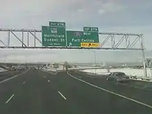
| 0.000 | 0.000 | I-70 exit 278; north end of expressway section | |||
| 0.463 | 0.745 | I-270 exit 4; south end of expressway section; southbound access via Northfield Boulevard exit | |||
| 0.637 | 1.025 | Northfield Boulevard | Interchange; North end of expressway section | ||
| 1.317 | 2.120 | 53rd Place | Northern terminus; road continues as Quebec Street | ||
| 1.000 mi = 1.609 km; 1.000 km = 0.621 mi | |||||
References
- "Segment Descriptions for Highway 35". Colorado Department of Transportation. Retrieved 2010-03-13.
- Salek, Matthew E. (January 30, 2010). "Colorado Routes 20–39". Retrieved March 13, 2010.
- Colorado Department of Transportation. "Map of Denver County, Colorado" (PDF). Retrieved 2010-05-17.