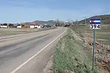
Colorado State Highway 394
State Highway 394 (SH 394) is a 9.378 mi (15.092 km) long state highway in northwestern Colorado. SH 394's western terminus is at U.S. Route 40 (US 40) and SH 13 in Craig, and the eastern terminus is at the Moffat–Routt county line.
| ||||
|---|---|---|---|---|
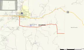 Map of Moffat County in northwestern Colorado with SH 394 highlighted in red | ||||
| Route information | ||||
| Maintained by CDOT | ||||
| Length | 9.378 mi[1] (15.092 km) | |||
| Major junctions | ||||
| West end | ||||
| East end | Moffat–Routt county line | |||
| Location | ||||
| Counties | Moffat | |||
| Highway system | ||||
Colorado State Highways
| ||||

Route description
SH 394 begins in Craig at the intersection of Ranney Street and West Victory Way (carrying westbound US 40 and SH 13), proceeding south on Ranney Street. One block later, SH 394 crosses the eastbound direction of the US 40/SH 13 one-way pair. It continues south for approximately 1.2 miles (1.9 km) before turning east to roughly parallel US 40. The highway ends at the county line between Moffat County and Routt County, after a total distance of 9.378 miles (15.092 km). The road continues east to rejoin US 40 at Hayden; however, it is not a part of the state highway system east of the county line, and portions of it are unimproved.
Major intersections
The entire route is in Moffat County.
| Location | mi[1] | km | Destinations | Notes | |
|---|---|---|---|---|---|
| Craig | 0.000 | 0.000 | Western terminus; one-way westbound road | ||
| 0.124 | 0.200 | One-way eastbound road | |||
| | 9.378 | 15.092 | Moffat–Routt county line | Eastern terminus | |
| 1.000 mi = 1.609 km; 1.000 km = 0.621 mi | |||||
References
- "Highway Data Explorer, Online Transportation Information System". Colorado Department of Transportation. Archived from the original on 2012-09-10. Retrieved 2019-01-08.