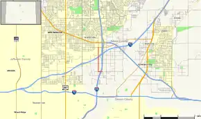
Colorado State Highway 53
State Highway 53 (SH 53) is a state highway in Adams County, Colorado, United States, north of Denver. SH 53's southern terminus is at Interstate 25 (I-25) and U.S. Route 87 (US 87) north of Denver, and the northern terminus is at SH 224 east of Westminster.
| ||||
|---|---|---|---|---|
| Broadway Street | ||||
 Map of Adams County in north central Colorado with SH 53 highlighted in red | ||||
| Route information | ||||
| Maintained by CDOT | ||||
| Length | 1.663 mi[1] (2.676 km) | |||
| Major junctions | ||||
| South end | ||||
| North end | ||||
| Location | ||||
| Counties | Adams | |||
| Highway system | ||||
Colorado State Highways
| ||||
Route description
SH 53 begins at the 58th Avenue interchange (exit 215) on I-25. After a short distance west on 58th Avenue, the route turns north on Broadway Street, crossing under Interstate 76 with no access and ending at 70th Avenue (SH 224).[2][1]
History
In 1971-1972, Colorado constructed an extension of Broadway Street from 66th Avenue north to SH 224, including a bridge over Clear Creek. Along with existing portions of Broadway Street and 58th Avenue, the new roadway was designated State Highway 53.[3][4][5]
Major intersections
The entire route is in Adams County.
| Location | mi | km | Destinations | Notes | |
|---|---|---|---|---|---|
| | 0.000 | 0.000 | Southern terminus; I-25 exit 215 | ||
| | 0.238 | 0.383 | Broadway Street / East 58th Avenue | SH 53 turns from East 58th Avenue onto Broadway Street | |
| | 1.663 | 2.676 | Northern terminus | ||
| 1.000 mi = 1.609 km; 1.000 km = 0.621 mi | |||||
References
- Colorado Department of Transportation, Highway Data Explorer, accessed November 2013
- Google Maps including Street View photographs, accessed November 2013
- Colorado Department of Transportation, official highway maps: 1971, 1972
- United States Geological Survey, Commerce City 1:24000 Archived November 14, 2013, at the Wayback Machine, 1969
- United States Geological Survey, Commerce City 1:24000 Archived November 14, 2013, at the Wayback Machine, 1973
