Conejo Mountain
Conejo Mountain is a 1,814-foot-high mountain (553 m) in Ventura County, California near Camarillo on the eastern boundary of the Oxnard Plain.[1][2][3] At the western edge of the Conejo Valley, it is adjacent to the Santa Monica Mountains. Crossing what was once a formidable barrier for travelers, U.S. Route 101 passes through the area on the steep Conejo Grade.[4]
| Conejo Mountain | |
|---|---|
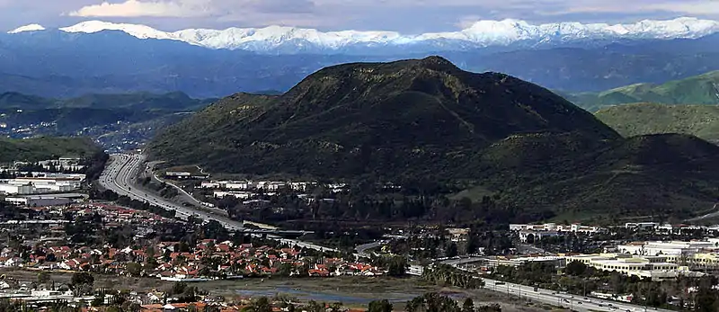 Conejo Grade cuts through the Conejo Hills. | |
| Highest point | |
| Elevation | 1,814 ft (553 m) |
| Coordinates | 34°11′18″N 118°59′4″W |
| Geography | |
| Location | Camarillo, California |
| Topo map | Camarillo East |
The mountain was once a large volcano about 14 million years ago, but it has been extinct for millions of years. The mountain was under sea-level at one point.[5] Mining operations have been ongoing here since 1959 and most of the mountain is owned by the Pacific Rock mining operation.[6]
The Santa Monica Mountains Conservancy, Pleasant Valley Recreation and Park District and Conejo Open Space Conservation Agency have interest in administrating the area as protected open space.[6] Trails reach into the area from Pepper Tree Playfield and Dos Vientos Community Park via Dos Vientos Open Space in southwestern Newbury Park.[7][8][9][10][11]
Sources
- McKinney, John (2005). California's National Parks: A Day Hiker's Guide. Wilderness Press. Page 322. ISBN 9780899973876.
- Niven, Paul R. (2009). Roadmaps and Revelations: Finding the Road to Business Success on Route 101. John Wiley & Sons. Page 167. ISBN 9780470180013.
- Gustafson, Robert and Philip Wilson Rundel (2005). Introduction to the plant life of southern California: coast to foothills. University of California Press. Page 279. ISBN 9780520236165.
- Pols, Mary F. (February 11, 1996) "ON THE ROAD: Journeys Along Ventura County's Highways" Los Angeles Times
- Sprankling, Miriam (2002). Discovering the Story of The Conejo Valley. Newbury Park, CA: Conejo Valley Historical Society. Page 5. ISBN 0-9725233-0-8.
- Whitnall, Becca (March 2, 2017). "Conservancy eyes Conejo Mountain". Thousand Oaks Acorn. Archived from the original on 2017-03-02.
- Edwads, Steve (2000). Rock Climbing Santa Barbara and Ventura. Globe Pequot. Page 47. ISBN 9781560446873.
- Stone, Robert (2011). Day Hikes Around Ventura County. Day Hike Books. Pages 178-180. ISBN 9781573420624.
- Conejo Open Space Foundation. "Dos Vientos Moderate Hike – Six Mile Loop". www.cosf.org. Retrieved 1 December 2018.
- Murphy, Kelly (2012). Local Multi-Use Trails. Kelly Murphy. Page 88. ISBN 9781479165599.
- "Archived copy". Archived from the original on 2016-03-06. Retrieved 2016-02-28.CS1 maint: archived copy as title (link)