Connecticut Route 607
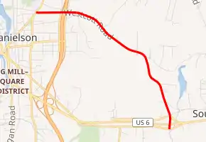
State Road 607 (SR 607; also known as Westcott Road) is a 2.54-mile-long (4.09 km) unsigned state road in eastern Connecticut which runs an inverted "L" pattern from U.S. Route 6 (US 6) to Route 12.
| State Road 607 | |
|---|---|
| Westcott Road | |
| |
| Route information | |
| Maintained by ConnDOT | |
| Length | 2.54 mi (4.09 km) |
| Existed | 1968–present |
| Major junctions | |
| South end | |
| North end | |
| Location | |
| Counties | Windham |
| Highway system | |
| |
Route description
SR 607 begins at US 6 eastbound onramp and South Frontage Road in the southern portion of the town of Killingly. It runs north, intersecting with SR 618 (North Frontage Road) and Horse Hill Road before intersecting with Halls Hill Road. The road passes over an unnamed tributary of Fall Brook with Tetreault pond to the east of the road. From there, it intersects with Cranberry Bog Road and Korpita Road before passing over Fall Brook itself. It then intersects with Mashentuck Road, Hillside View, Reynolds Street, and Baker Street before intersecting with Knox Avenue to the south. To the north of the Knox Avenue Intersection, there is an on-ramp to Interstate 395 (I-395) at its exit 38. Travelers on Route 607 can only access I-395 northbound, because there is no southbound on-ramp. The road passes under I-395 before intersecting with the southbound off-ramp. It then travels west, intersecting with Gauthier Avenue and Sprague Street before it reaches Route 12 and ends.[1]
History
In 1959, Westcott Road was given a highway designation, being called US 6A. It was called this until 1968, when the divided highway section of US 6 opened. Westcott Road was then given a Connecticut State Road Designation, being known as Route 607.
Major intersections
The entire route is in Killingly, Windham County.
| mi[2] | km | Destinations | Notes | ||
|---|---|---|---|---|---|
| 0.00– 0.18 | 0.00– 0.29 | ||||
| 2.15– 2.22 | 3.46– 3.57 | Exit 38 (I-395); I-395 northbound entrance / southbound exit only | |||
| 2.54 | 4.09 | ||||
| 1.000 mi = 1.609 km; 1.000 km = 0.621 mi | |||||
References
- Google (January 4, 2020). "Connecticut Route 607" (Map). Google Maps. Google. Retrieved January 4, 2020.
- Connecticut Department of Transportation (December 31, 2014). "Highway Log" (PDF). Connecticut Department of Transportation.