Cook, South Australia
Cook is a railway station and crossing loop located in the Australian state of South Australia on the Trans-Australian Railway in the locality of Nullarbor about 826 kilometres (513 mi) west by rail of Port Augusta and about 100 kilometres (62 mi) north of the Eyre Highway via an unsealed road.[4][1]
| Cook Nullarbor[1], South Australia | |
|---|---|
 A disused building in Cook | |
 Cook | |
| Coordinates | 30°37′03″S 130°24′40″E[1] |
| Population | 4 (2009)[2] |
| Established | 1917 |
| Elevation | 120 m (394 ft)[3] |
| Time zone | ACST (UTC+9:30) |
| • Summer (DST) | ACDT (UTC+10:30) |
| LGA(s) | Pastoral Unincorporated Area[1] |
History
Cook was created in 1917 when the railway was built and is named after the sixth Prime Minister of Australia, Joseph Cook.[5] The town depended on the Tea and Sugar Train for the delivery of supplies, and is on the longest stretch of straight railway in the world, at 478 kilometres (297 mi) which stretches from Ooldea to beyond Loongana. When the town was active, water was pumped from an underground Artesian aquifer but now, all water is carried in by train.
The 1964 black-and-white film Nullarbor Hideout was set in and around Cook.
Today
In 2009, Cook was said to have a resident population of four,[2] and is essentially a ghost town. The town was effectively closed in 1997 when the railways were privatised and the new owners did not need a support town there, although the diesel refuelling facilities remain, and there is overnight accommodation for train drivers. Cook is the only scheduled stop on the Nullarbor Plain for the Indian Pacific passenger train across Australia and has little other than curiosity value for the passengers. The bush hospital is closed, but the town maintains some medical supplies in the event of a train disaster.[6] The hospital advertised itself at the station with the catch cry "If you're crook come to Cook".[7] The shop is only opened while the Indian Pacific is in town. It has a few houses and fuel tanks for the locomotives. The crossing loop can cross trains up to 1,800 metres (5,900 ft) long. The former airstrip is known as a place to spot inland dotterel.[8]
An interview with a resident revealed that they use both the Western Australian and South Australian time zones, for people from both states, so they do not have to adjust their watches. When the railway was sold, eight transportable houses were taken away and made into holiday houses on the coast.[9]
As of 2016, Cook is officially described as 'unbounded locality' which is not to be used as an address and since 2013, it has been located in the locality of Nullarbor.[1]
 The Indian Pacific at Cook
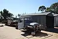 Ghost town Cook, November 2011
 View of Railway Station in 2012 looking east along the line.
Climate
| Climate data for Cook, South Australia | |||||||||||||
|---|---|---|---|---|---|---|---|---|---|---|---|---|---|
| Month | Jan | Feb | Mar | Apr | May | Jun | Jul | Aug | Sep | Oct | Nov | Dec | Year |
| Record high °C (°F) | 48.7 (119.7) |
46.7 (116.1) |
46.5 (115.7) |
41.1 (106.0) |
36.0 (96.8) |
30.0 (86.0) |
34.2 (93.6) |
33.6 (92.5) |
39.0 (102.2) |
43.5 (110.3) |
46.5 (115.7) |
46.3 (115.3) |
48.7 (119.7) |
| Average high °C (°F) | 33.0 (91.4) |
32.2 (90.0) |
30.0 (86.0) |
25.9 (78.6) |
21.8 (71.2) |
18.8 (65.8) |
18.2 (64.8) |
20.1 (68.2) |
23.5 (74.3) |
26.6 (79.9) |
29.7 (85.5) |
31.5 (88.7) |
25.9 (78.7) |
| Average low °C (°F) | 15.0 (59.0) |
15.3 (59.5) |
13.7 (56.7) |
10.9 (51.6) |
7.8 (46.0) |
5.4 (41.7) |
4.3 (39.7) |
5.1 (41.2) |
7.2 (45.0) |
9.5 (49.1) |
11.9 (53.4) |
13.9 (57.0) |
10.0 (50.0) |
| Record low °C (°F) | 4.5 (40.1) |
4.4 (39.9) |
4.5 (40.1) |
2.0 (35.6) |
−1.8 (28.8) |
−3.8 (25.2) |
−4.5 (23.9) |
−3.3 (26.1) |
−0.7 (30.7) |
0.0 (32.0) |
3.7 (38.7) |
5.6 (42.1) |
−4.5 (23.9) |
| Average rainfall mm (inches) | 12.1 (0.48) |
14.6 (0.57) |
16.9 (0.67) |
16.2 (0.64) |
15.1 (0.59) |
16.8 (0.66) |
13.2 (0.52) |
15.1 (0.59) |
13.2 (0.52) |
17.3 (0.68) |
14.9 (0.59) |
18.2 (0.72) |
183.6 (7.23) |
| Source: Australian Government, Bureau of Meteorology[3] | |||||||||||||
References
- "Search results for 'Cook, LOCU' with the following datasets selected - 'Suburbs and Localities', 'Local Government Areas', 'Gazetteer' and 'Railways'". Location SA Map Viewer. South Australian government. Retrieved 17 February 2018.
- Time Out Great Train Journeys of the World. Time Out. 2009. p. 50.
- "Climate statistics for Australian locations: Cook". Commonwealth of Australia , Bureau of Meteorology. Retrieved 26 October 2018.
- (1927)Travel in comfort across Australia on the Trans-Australian Railway. Melbourne : Commonwealth Railways. internal map titled Map shewing Connections between Capital Cities via Trans- Australian Railway
- Manning, Geoffrey H. (2012). "Search result for 'Cook'" (PDF). A Compendium of the Place Names of South Australia From Aaron Creek to Zion Hill With 54 Complementary Appendices Researched and written by Geoffrey H. Manning. Geoffrey H. Manning. Retrieved 17 February 2018.
- Fuller, Basil (1977). Nullarbor Lifelines. p. 93.
- Tisdall, Nigel (16 January 1999). "Australia: If you're crook, do the locomotion". The Daily Telegraph. Retrieved 22 May 2012.
- The Complete Guide to Finding the Birds of Australia. Csiro. 2012. p. 176.
- "Cook, Australia". ULiveWhere.com. Archived from the original on 11 March 2007. Retrieved 23 January 2012.
| Preceding station | Journey Beyond | Following station | ||
|---|---|---|---|---|
| Rawlinna towards East Perth |
Indian Pacific | Adelaide towards Sydney | ||