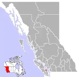
Coombs, British Columbia
Coombs is a small community on Vancouver Island in British Columbia, situated on provincial highway 4A approximately 10 km (6.2 mi) west of Parksville. Coombs is home to approximately 1,327 people and is renowned for its Old Country Market (which features a family of goats living on the roof), Butterfly World (which includes a small indoor tropical rainforest), the 106 year old Coombs Fall Fair and the Coombs Bluegrass Festival held every B.C. Day weekend. The history of Coombs goes back many years. The Ford House which is the old log house situated on the Alberni Highway is dated back to the early 1900s. The pioneer Walter Ford house was completed in 1911. Next to the Ford House is the old General Store which also always housed the General Post Office. The Coombs Fair Grounds is an active place throughout the year. The Rodeo Grounds just up the highway heading towards Port Alberni is a successful and active place during the summer months. The railway line is also a huge part of the history of Coombs. Along with the United Church and just over the French Creek Bridge is the French Creek School, opened in 1912, which closed in 2015 but is used now as a Coombs Community Commons. French Creek school was a huge asset to the community for over 100 years.

The community was established in 1910 under a Salvation Army emigration plan to relocate people from the crowded cities in Great Britain. This new town was named after Commissioner Thomas Bales Coombs, head of the Salvation Army movement in Canada in the early 1900s. Coombs was retiring in 1911 so the Salvation Army honored him by naming the new Vancouver Island colony after him. Unfortunately Commissioner Coombs never visited the Coombs Colony.
A website (http://www.coombshistory.com) has been setup to capture the history of Coombs BC.
Climate
Under the Köppen climate classification, Coombs is located at the northernmost limits of the cool dry-summer subtropical zone (Csb) or cool-summer Mediterranean climate, due to its dry summers.[1]
| Climate data for Coombs | |||||||||||||
|---|---|---|---|---|---|---|---|---|---|---|---|---|---|
| Month | Jan | Feb | Mar | Apr | May | Jun | Jul | Aug | Sep | Oct | Nov | Dec | Year |
| Record high °C (°F) | 15.0 (59.0) |
18.0 (64.4) |
22.5 (72.5) |
26.0 (78.8) |
30.0 (86.0) |
33.5 (92.3) |
35.0 (95.0) |
33.0 (91.4) |
33.0 (91.4) |
24.0 (75.2) |
17.0 (62.6) |
17.0 (62.6) |
35.0 (95.0) |
| Average high °C (°F) | 6.0 (42.8) |
7.6 (45.7) |
10.3 (50.5) |
13.8 (56.8) |
17.6 (63.7) |
20.6 (69.1) |
24.0 (75.2) |
24.2 (75.6) |
20.6 (69.1) |
13.8 (56.8) |
8.2 (46.8) |
5.5 (41.9) |
14.4 (57.9) |
| Daily mean °C (°F) | 2.8 (37.0) |
3.4 (38.1) |
5.4 (41.7) |
8.2 (46.8) |
11.6 (52.9) |
14.6 (58.3) |
17.2 (63.0) |
17.1 (62.8) |
13.8 (56.8) |
8.9 (48.0) |
4.7 (40.5) |
2.6 (36.7) |
9.2 (48.6) |
| Average low °C (°F) | −0.4 (31.3) |
−0.9 (30.4) |
0.5 (32.9) |
2.5 (36.5) |
5.5 (41.9) |
8.4 (47.1) |
10.4 (50.7) |
10.0 (50.0) |
7.0 (44.6) |
3.9 (39.0) |
1.1 (34.0) |
−0.4 (31.3) |
4.0 (39.2) |
| Record low °C (°F) | −14.5 (5.9) |
−17.5 (0.5) |
−9.0 (15.8) |
−5.0 (23.0) |
−3.0 (26.6) |
2.0 (35.6) |
3.0 (37.4) |
2.0 (35.6) |
−2.0 (28.4) |
−8.0 (17.6) |
−18.0 (−0.4) |
−18.0 (−0.4) |
−18.0 (−0.4) |
| Average precipitation mm (inches) | 176.3 (6.94) |
110.1 (4.33) |
109.0 (4.29) |
75.1 (2.96) |
56.3 (2.22) |
46.6 (1.83) |
24.4 (0.96) |
34.5 (1.36) |
39.3 (1.55) |
113.9 (4.48) |
188.2 (7.41) |
164.9 (6.49) |
1,138.5 (44.82) |
| Average rainfall mm (inches) | 162.8 (6.41) |
100.1 (3.94) |
103.1 (4.06) |
75.1 (2.96) |
56.3 (2.22) |
46.6 (1.83) |
24.4 (0.96) |
34.5 (1.36) |
39.3 (1.55) |
113.2 (4.46) |
180.7 (7.11) |
157.3 (6.19) |
1,093.2 (43.04) |
| Average snowfall cm (inches) | 13.5 (5.3) |
10.1 (4.0) |
5.9 (2.3) |
0.0 (0.0) |
0.0 (0.0) |
0.0 (0.0) |
0.0 (0.0) |
0.0 (0.0) |
0.0 (0.0) |
0.7 (0.3) |
7.5 (3.0) |
7.6 (3.0) |
45.2 (17.8) |
| Average precipitation days (≥ 0.2 mm) | 19.8 | 15.8 | 18.3 | 15.7 | 13.6 | 11.7 | 6.5 | 7.0 | 8.0 | 17.2 | 20.5 | 19.3 | 173.4 |
| Average rainy days (≥ 0.2 mm) | 18.0 | 14.5 | 17.8 | 15.7 | 13.6 | 11.7 | 6.5 | 7.0 | 8.0 | 17.1 | 19.7 | 18.0 | 167.6 |
| Average snowy days (≥ 0.2 cm) | 2.8 | 2.0 | 1.5 | 0.0 | 0.1 | 0.0 | 0.0 | 0.0 | 0.0 | 0.2 | 1.4 | 2.4 | 10.3 |
| Source: [2] | |||||||||||||
Gallery

References
- Kottek, M.; J. Grieser; C. Beck; B. Rudolf; F. Rubel (2006). "World Map of the Köppen-Geiger climate classification updated" (PDF). Meteorol. Z. 15 (3): 259–263. doi:10.1127/0941-2948/2006/0130. Retrieved November 22, 2012.
- "Calculation Information for 1981 to 2010 Canadian Normals Data". Environment Canada. Archived from the original on February 25, 2014. Retrieved July 9, 2013.