Corning, Kansas
Corning is a city in Nemaha County, Kansas, United States. As of the 2010 census, the city population was 157.[6]
Corning, Kansas | |
|---|---|
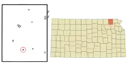 Location within Nemaha County and Kansas | |
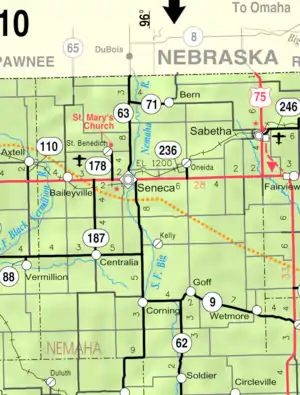 KDOT map of Nemaha County (legend) | |
| Coordinates: 39°39′23″N 96°1′49″W | |
| Country | United States |
| State | Kansas |
| County | Nemaha |
| Incorporated | 1889 |
| Area | |
| • Total | 0.28 sq mi (0.71 km2) |
| • Land | 0.28 sq mi (0.71 km2) |
| • Water | 0.00 sq mi (0.00 km2) |
| Elevation | 1,342 ft (409 m) |
| Population | |
| • Total | 157 |
| • Estimate (2019)[3] | 164 |
| • Density | 594.20/sq mi (229.78/km2) |
| Time zone | UTC-6 (CST) |
| • Summer (DST) | UTC-5 (CDT) |
| ZIP code | 66417 |
| Area code | 785 |
| FIPS code | 20-15725 [4] |
| GNIS ID | 0473218 [5] |
History
.jpg.webp)
Corning was founded in 1857 a mile and a half distant from the present town. In 1867, Corning was moved to the site it now occupies.[7] It was named for Erastus Corning, of New York.[8]
Geography
Corning is located at 39°39′23″N 96°1′49″W (39.656418, -96.030344).[9] According to the United States Census Bureau, the city has a total area of 0.27 square miles (0.70 km2), all of it land.[10]
Demographics
| Historical population | |||
|---|---|---|---|
| Census | Pop. | %± | |
| 1880 | 63 | — | |
| 1890 | 291 | 361.9% | |
| 1900 | 425 | 46.0% | |
| 1910 | 411 | −3.3% | |
| 1920 | 419 | 1.9% | |
| 1930 | 340 | −18.9% | |
| 1940 | 352 | 3.5% | |
| 1950 | 254 | −27.8% | |
| 1960 | 240 | −5.5% | |
| 1970 | 162 | −32.5% | |
| 1980 | 158 | −2.5% | |
| 1990 | 142 | −10.1% | |
| 2000 | 170 | 19.7% | |
| 2010 | 157 | −7.6% | |
| 2019 (est.) | 164 | [3] | 4.5% |
| U.S. Decennial Census | |||
2010 census
As of the census[2] of 2010, there were 157 people, 57 households, and 40 families residing in the city. The population density was 581.5 inhabitants per square mile (224.5/km2). There were 67 housing units at an average density of 248.1 per square mile (95.8/km2). The racial makeup of the city was 94.9% White, 2.5% Native American, 1.3% from other races, and 1.3% from two or more races. Hispanic or Latino of any race were 1.3% of the population.
There were 57 households, of which 42.1% had children under the age of 18 living with them, 59.6% were married couples living together, 7.0% had a female householder with no husband present, 3.5% had a male householder with no wife present, and 29.8% were non-families. 26.3% of all households were made up of individuals, and 10.5% had someone living alone who was 65 years of age or older. The average household size was 2.75 and the average family size was 3.43.
The median age in the city was 32.8 years. 33.1% of residents were under the age of 18; 4.5% were between the ages of 18 and 24; 30.5% were from 25 to 44; 23.6% were from 45 to 64; and 8.3% were 65 years of age or older. The gender makeup of the city was 51.6% male and 48.4% female.
2000 census
As of the census[4] of 2000, there were 170 people, 64 households, and 41 families residing in the city. The population density was 614.4 people per square mile (234.4/km2). There were 70 housing units at an average density of 253.0 per square mile (96.5/km2). The racial makeup of the city was 96.47% White, 1.76% Native American, 1.18% Pacific Islander, 0.59% from other races. Hispanic or Latino of any race were 0.59% of the population.
There were 64 households, out of which 46.9% had children under the age of 18 living with them, 51.6% were married couples living together, 10.9% had a female householder with no husband present, and 34.4% were non-families. 29.7% of all households were made up of individuals, and 15.6% had someone living alone who was 65 years of age or older. The average household size was 2.66 and the average family size was 3.40.
In the city, the population was spread out, with 35.9% under the age of 18, 10.0% from 18 to 24, 27.1% from 25 to 44, 15.9% from 45 to 64, and 11.2% who were 65 years of age or older. The median age was 28 years. For every 100 females, there were 91.0 males. For every 100 females age 18 and over, there were 87.9 males.
The median income for a household in the city was $27,250, and the median income for a family was $32,500. Males had a median income of $26,250 versus $17,083 for females. The per capita income for the city was $10,135. About 6.8% of families and 10.2% of the population were below the poverty line, including 4.8% of those under the age of eighteen and 15.4% of those 65 or over.
References
- "2019 U.S. Gazetteer Files". United States Census Bureau. Retrieved July 24, 2020.
- "U.S. Census website". United States Census Bureau. Retrieved 2012-07-06.
- "Population and Housing Unit Estimates". United States Census Bureau. May 24, 2020. Retrieved May 27, 2020.
- "U.S. Census website". United States Census Bureau. Retrieved 2008-01-31.
- "US Board on Geographic Names". United States Geological Survey. 2007-10-25. Retrieved 2008-01-31.
- "2010 City Population and Housing Occupancy Status". U.S. Census Bureau. Retrieved July 2, 2011.
- Kansas State Historical Society (1916). Biennial Report of the Board of Directors of the Kansas State Historical Society. Kansas State Printing Plant. pp. 249.
- Tennal, Ralph (1916). History of Nemaha County, Kansas. Standard Publishing Company. pp. 49.
- "US Gazetteer files: 2010, 2000, and 1990". United States Census Bureau. 2011-02-12. Retrieved 2011-04-23.
- "US Gazetteer files 2010". United States Census Bureau. Archived from the original on 2012-07-02. Retrieved 2012-07-06.
External links
| Wikimedia Commons has media related to Corning, Kansas. |
- City
- Schools
- USD 380, local school district
- Maps
- Corning City Map, KDOT
Municipalities and communities of Nemaha County, Kansas, United States | ||
|---|---|---|
| Cities |  Map of Kansas highlighting Nemaha County | |
| Unincorporated communities | ||
| Footnotes | †This populated place is designated a Census-Designated Place (CDP) by the United States Census Bureau, ‡This populated place also has portions in an adjacent county or counties. | |
| ||