Corning (town), New York
Corning is a town in Steuben County, New York, US. The town is in the eastern part of the county and borders the city of Corning. The town population was 6,426 at the 2000 census. The town is named after Erastus Corning, a financier.
Corning | |
|---|---|
 Corning Location within the state of New York  Corning Corning (the United States) | |
| Coordinates: 42°8′28″N 77°1′57″W | |
| Country | United States |
| State | New York |
| County | Steuben |
| Area | |
| • Total | 37.35 sq mi (96.74 km2) |
| • Land | 36.85 sq mi (95.44 km2) |
| • Water | 0.50 sq mi (1.30 km2) |
| Elevation | 1,093 ft (333 m) |
| Population (2010) | |
| • Total | 6,270 |
| • Estimate (2016)[2] | 6,248 |
| • Density | 169.55/sq mi (65.46/km2) |
| Time zone | UTC-5 (Eastern (EST)) |
| • Summer (DST) | UTC-4 (EDT) |
| ZIP codes | 14830-14831 |
| Area code(s) | 607 |
| FIPS code | 36-18267 |
| GNIS feature ID | 0978868 |
History
The first settlement was near the current city of Corning around 1789. The Town of Corning began as the "Town of Painted Post" in 1796 when the county was founded. In 1836, the name was changed to honor an important investor in the local economy. The community of Corning set itself apart as a village in 1848 and became a city in 1890.
The town of Corning was incorporated in 1852.[3]
Geography
According to the United States Census Bureau, the town has a total area of 37.3 square miles (97 km2), of which 0.4 square miles (1.0 km2) of it (1.07%) is water.
The Chemung River, formed by the confluence of the Cohocton River and the Tioga River a few miles west of the town, flows through the town, and the city of Corning.
The east town line is the border of Chemung County, (Town of Big Flats).
Interstate 86, New York State Route 17, New York State Route 225, New York State Route 352, New York State Route 414, and New York State Route 415 pass through the town.
Demographics
| Historical population | |||
|---|---|---|---|
| Census | Pop. | %± | |
| 1820 | 2,088 | — | |
| 1830 | 974 | −53.4% | |
| 1840 | 1,674 | 71.9% | |
| 1850 | 4,372 | 161.2% | |
| 1860 | 6,003 | 37.3% | |
| 1870 | 6,502 | 8.3% | |
| 1880 | 7,402 | 13.8% | |
| 1890 | 1,638 | −77.9% | |
| 1900 | 1,937 | 18.3% | |
| 1910 | 2,391 | 23.4% | |
| 1920 | 2,857 | 19.5% | |
| 1930 | 2,997 | 4.9% | |
| 1940 | 3,152 | 5.2% | |
| 1950 | 4,275 | 35.6% | |
| 1960 | 6,732 | 57.5% | |
| 1970 | 7,523 | 11.7% | |
| 1980 | 6,846 | −9.0% | |
| 1990 | 6,367 | −7.0% | |
| 2000 | 6,426 | 0.9% | |
| 2010 | 6,270 | −2.4% | |
| 2016 (est.) | 6,248 | [2] | −0.4% |
| U.S. Decennial Census[4] | |||
As of the census[5] of 2000, there were 6,426 people, 2,491 households, and 1,840 families residing in the town. The population density was 174.1 people per square mile (67.2/km2). There were 2,626 housing units at an average density of 71.1 per square mile (27.5/km2). The racial makeup of the town was 95.25% White, 2.46% Black or African American, 0.20% Native American, 1.35% Asian, 0.11% from other races, and 0.62% from two or more races. Hispanic or Latino of any race were 0.67% of the population.
There were 2,491 households, out of which 32.5% had children under the age of 18 living with them, 59.8% were married couples living together, 9.8% had a female householder with no husband present, and 26.1% were non-families. 21.3% of all households were made up of individuals, and 9.0% had someone living alone who was 65 years of age or older. The average household size was 2.57 and the average family size was 2.96.
In the town, the population was spread out, with 25.4% under the age of 18, 6.8% from 18 to 24, 27.7% from 25 to 44, 25.8% from 45 to 64, and 14.4% who were 65 years of age or older. The median age was 39 years. For every 100 females, there were 97.7 males. For every 100 females age 18 and over, there were 94.2 males.
The median income for a household in the town was $44,649, and the median income for a family was $51,470. Males had a median income of $40,542 versus $25,804 for females. The per capita income for the town was $23,149. About 5.9% of families and 8.2% of the population were below the poverty line, including 10.9% of those under age 18 and 2.8% of those age 65 or over.
Communities and locations in the Town of Corning
- Corning Community College – A public junior college west of South Corning.
- Corning Manor – A hamlet southeast of Corning city by Interstate 86.
- Denmark – A hamlet and suburban community northeast of Corning city.
- East Corning – A location near the east town line on NY-352.
- French Mill – A hamlet south of Corning on NY-225.
- Gibson – A hamlet southeast of Corning city on the north bank of the Chemung River.
- Guthrie Corning Hospital
- Narrows Creek – A stream entering the Chemung River by Gibson.
- Post Creek – A stream entering the Chemung River by Corning city.
- Riverside – A village located on NY-415 that borders the city of Corning on its west side.
- South Corning – A village located on NY-225 south of the city of Corning.
References
- "2016 U.S. Gazetteer Files". United States Census Bureau. Retrieved July 5, 2017.
- "Population and Housing Unit Estimates". Retrieved June 9, 2017.
- "The History of the Town of Corning". Town of Corning. Archived from the original on December 11, 2012. Retrieved June 24, 2012.
- "Census of Population and Housing". Census.gov. Retrieved June 4, 2015.
- "U.S. Census website". United States Census Bureau. Retrieved 2008-01-31.
External links
Municipalities and communities of Steuben County, New York, United States | ||
|---|---|---|
| Cities | 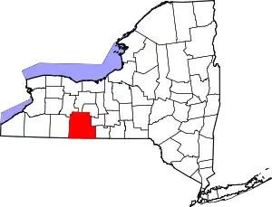 | |
| Towns | ||
| Villages | ||
| CDPs | ||
| Hamlets |
| |
| Footnotes | ‡This populated place also has portions in an adjacent county or counties | |
| ||