Corrida de Cori
Corrida de Cori is a range of Pliocene-Pleistocene volcanoes.[2] It is located in the Salta province of Argentina.[3] Cerro Escorial is part of this range,[4]:231 Cerro Negro (5,579 metres (18,304 ft)) and Cerro Corrida de Cori (c. 5,400 metres (17,700 ft)) are other summits, Lastarria may also be linked.[5][6] Some glacial activity in the area has degraded volcanic landforms, but very little erosion is evident.[5]
It forms a volcanic chain with Llullaillaco that extends towards Antofalla and Galán. This lineament is known as "Archibarca lineament".[7] Cerro Corrida de Cori and Cerro Negro are associated with the intersections between this lineament and ENE lineaments.[8] Fault zones on the area have controlled the magma ascent, probably facilitating the eruption of fairly primitive basaltic lavas.[2] Among these faults is the Imilac-Salina del Fraile lineament.[9]
Geological history
Activity commenced in the Miocene with basaltic andesites and dacitic ignimbrites and ended in the late Quaternary with basaltic andesites in form of cinder cones.[6] K-Ar dates of 12 mya and 8.0 ± 0.3 have been found at Cerro Negro.[10] Lava flows found on Escorial and Cerro Corrida de Cori are the latest volcanic events and post-date the hydrothermal alteration; one date from Escorial is 0.342 ± 0.025 mya. Most Escorial lava flows head southwest.[11] These Escorial lava flows are accompanied by andesitic blocks from possibly Vulcanian explosive activity. East of Corrida de Cori range a cinder cone accompanied by a much smaller vent was constructed on top of older eruption products and generated a lava flow that descended towards Salar Rio Grande. This cone may be of Holocene age,[12] considering the appearance of the blockly lava flows.[13] Present day geothermal activity is found at Lastarria and in form of fumarole spires, mud vents and warm springs at Escorial. Some of these originate by the summit lava flow of Cerro Escorial.[5][12]
Rocks and minerals
A major ignimbrite is found in the Escorial area and extends in a butterfly shape over 105 square kilometres (41 sq mi) with a thickness of c. 6 metres (20 ft). Probably erupted from Cerro Escorial, it extends 10 kilometres (6.2 mi) away from Escorial. It has a total volume of c. 0.6 cubic kilometres (0.14 cu mi) and consists of crystal rich dacite with large amounts of xenoliths. Where the ignimbrite was dammed by older lava flows, it formed internal wave structures. The surface of the ignimbrite is grooved and rippled in appearance and is heavily influenced by aeolian activity. Dating is uncertain, with older dates including 1.3 ± 0.6 mya but a more precise recent date is 0.457 ± 0.013 mya.[10][11] This ignimbrite was likely formed by a column collapse[14] and is known as the Caletones Cori Ignimbrite.[15]
Corrida de Cori volcanism is calc-alkaline and consists of potassium rich andesite as well as basaltic andesites. The Cerro Escorial ignimbrite may be of crustal origin and is dacitic.[4]:201,222 Trachydacite is found at Cerro Negro.[16] The basement beneath Corrida de Cori is mostly buried, but occasional outcrops indicate Paleozoic granites and sedimentary and volcanic rocks.[5]
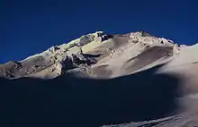
Hydrothermal and fumarolic alteration is widespread in this range. It has formed superficial sulfur deposits that have been mined at Cerro Escorial in the Mina Julia as well as deeper alteration which has been brought to the surface by the Cerro Escorial ignimbrite in form of quartz veins.[2] This hydrothermal alteration of susceptible rocks makes Corrida de Cori's peaks look snow-covered from a distance.[12] The Mina Julia sulfur mine was active until ~20 years before 2002,[5] from where a funicular bucket railway transported sulfur towards Mina la Casualidad by the salar.[12]
Climate
Weather measurements have been made in a weather station by a sulfur mine worker's camp,[17]:47 at an altitude of 5,100 metres (16,700 ft).[18] Research in 1976-1977 found average temperatures of −5.5 °C (22.1 °F) with a daily variability of c. 9 °C (48 °F).[1]:55 Wind in Corrida de Cori has been reported to have "a cooling power in winter similar to the South Pole in summer."[19] Wind speed reported in 1976-1977 after a row of measurements is 13.6 metres per second (45 ft/s) and air humidity about 40%.[1]:64,59 Winds are westerly and strongest in winter.[17]:49 During winter, the lower summits of Corrida de Cori can be snow-covered.[5]
| Climate data for Corrida de Cori (1956–1964) | |||||||||||||
|---|---|---|---|---|---|---|---|---|---|---|---|---|---|
| Month | Jan | Feb | Mar | Apr | May | Jun | Jul | Aug | Sep | Oct | Nov | Dec | Year |
| Record high °C (°F) | 10.0 (50.0) |
9.1 (48.4) |
9.9 (49.8) |
7.9 (46.2) |
4.9 (40.8) |
4.6 (40.3) |
1.0 (33.8) |
2.9 (37.2) |
4.9 (40.8) |
10.9 (51.6) |
8.5 (47.3) |
9.9 (49.8) |
10.9 (51.6) |
| Average high °C (°F) | 5.7 (42.3) |
4.5 (40.1) |
3.7 (38.7) |
0.3 (32.5) |
−2.2 (28.0) |
−5.3 (22.5) |
−6.4 (20.5) |
−4.7 (23.5) |
−2.9 (26.8) |
−0.1 (31.8) |
2.1 (35.8) |
5.5 (41.9) |
0.0 (32.0) |
| Daily mean °C (°F) | −0.4 (31.3) |
−0.9 (30.4) |
−1.6 (29.1) |
−4.2 (24.4) |
−6.4 (20.5) |
−9.0 (15.8) |
−9.9 (14.2) |
−8.9 (16.0) |
−7.4 (18.7) |
−4.9 (23.2) |
−3.2 (26.2) |
−0.3 (31.5) |
−4.8 (23.4) |
| Average low °C (°F) | −6.5 (20.3) |
−6.2 (20.8) |
−7.0 (19.4) |
−8.6 (16.5) |
−10.6 (12.9) |
−12.7 (9.1) |
−13.3 (8.1) |
−13.1 (8.4) |
−11.9 (10.6) |
−9.7 (14.5) |
−8.6 (16.5) |
−6.0 (21.2) |
−9.5 (14.9) |
| Record low °C (°F) | −13.2 (8.2) |
−12.2 (10.0) |
−14.2 (6.4) |
−18.2 (−0.8) |
−18.7 (−1.7) |
−25.2 (−13.4) |
−23.4 (−10.1) |
−21.7 (−7.1) |
−20.2 (−4.4) |
−21.2 (−6.2) |
−15.2 (4.6) |
−12.2 (10.0) |
−25.2 (−13.4) |
| Average precipitation mm (inches) | 1.5 (0.06) |
3.3 (0.13) |
1.8 (0.07) |
0.5 (0.02) |
2.1 (0.08) |
1.0 (0.04) |
1.3 (0.05) |
3.7 (0.15) |
4.6 (0.18) |
0.7 (0.03) |
0.0 (0.0) |
0.5 (0.02) |
21.1 (0.83) |
| Source: Servicio Meteorológico Nacional[20] | |||||||||||||
References
- Lauscher, Friedrich (1977). "Ergebnisse der Beobachtungen an den nordchilenischen Hochgebirgsstationen Collahuasi und Chuquicamata". 74.-75. Jahresbericht des Sonnblick-Vereines für die Jahre 1976-1977. Jahresberichte des Sonnblick-Vereines (in German). 1976/77. Vienna: Springer Vienna. pp. 43–66. doi:10.1007/978-3-7091-3980-6_6. ISBN 978-3-7091-3980-6.
- Richards and Villeneuve 2002, p.161
- Peralta, Paola; Múlgura de Romero, María E.; Denham, Silvia S.; Botta, Silvia M. (18 June 2008). "Revisión del Género Junellia (Verbenaceae)". Annals of the Missouri Botanical Garden. 95 (2): 338–390. doi:10.3417/2004167.
- Richards, Jeremy P.; Ullrich, Thomas; Kerrich, Robert (April 2006). "The Late Miocene–Quaternary Antofalla volcanic complex, southern Puna, NW Argentina: Protracted history, diverse petrology, and economic potential". Journal of Volcanology and Geothermal Research. 152 (3–4): 197–239. doi:10.1016/j.jvolgeores.2005.10.006.
- Richards and Villeneuve 2002, p.175
- Richards and Villeneuve 2002, p.174
- Richards, J.P.; Jourdan, F.; Creaser, R.A.; Maldonado, G.; DuFrane, S.A. (May 2013). "Geology, geochemistry, geochronology, and economic potential of Neogene volcanic rocks in the Laguna Pedernal and Salar de Aguas Calientes segments of the Archibarca lineament, northwest Argentina". Journal of Volcanology and Geothermal Research. 258: 48–49. doi:10.1016/j.jvolgeores.2013.04.004.
- Richards and Villeneuve 2002, p.183
- Naranjo et al. 2018, p.636
- Richards and Villeneuve 2002, p.177
- Richards and Villeneuve 2002, p.180
- Richards and Villeneuve 2002, pp.181-182
- "Unnamed". Global Volcanism Program. Smithsonian Institution.
- Richards and Villeneuve 2002, p.190
- Naranjo et al. 2018, p.635
- Richards and Villeneuve 2002, p.185
- Prohaska, Fritz (1957). "Über die meteorologischen Stationen der Hohen Kordillere Argentiniens". 51.-53. Jahresbericht des Sonnblick-Vereines für die Jahre 1953-1955. Jahresbericht des Sonnblick-Vereines (in German). 1953–55. Vienna: Springer Vienna. pp. 45–55. doi:10.1007/978-3-7091-5760-2_6. ISBN 978-3-7091-5760-2.
- DeForest Safford, Hugh (July 1999). "Brazilian Páramos II. Macro- and mesoclimate of the campos de altitude and affinities with high mountain climates of the tropical Andes and Costa Rica". Journal of Biogeography. 26 (4): 713. doi:10.1046/j.1365-2699.1999.00312.x.
- Prohaska, F. (March 1970). "Distinctive bioclimatic parameters of the subtropical-tropical andes". International Journal of Biometeorology. 14 (1): 9. doi:10.1007/BF01440674.
- "Clima de Mina La Casualidad (4200msnm) y Mina Julia (5200msnm)" (in Spanish). Servicio Meteorológico Nacional. Retrieved September 23, 2019.
Sources
- Naranjo, José Antonio; Villa, Víctor; Ramírez, Cristián; Arce, Carlos Pérez de (1 April 2018). "Volcanism and tectonism in the southern Central Andes: Tempo, styles, and relationships". Geosphere. 14 (2): 626–641. doi:10.1130/GES01350.1.
- Richards, Jeremy P; Villeneuve, Michael (August 2002). "Characteristics of late Cenozoic volcanism along the Archibarca lineament from Cerro Llullaillaco to Corrida de Cori, northwest Argentina". Journal of Volcanology and Geothermal Research. 116 (3–4): 161–200. doi:10.1016/S0377-0273(01)00329-8.
