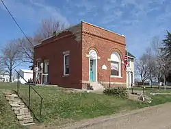
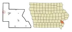
Cotter, Iowa
Cotter is a city in Louisa County, Iowa, United States. The population was 48 at the 2010 census. It is part of the Muscatine Micropolitan Statistical Area.
Cotter, Iowa | |
|---|---|
 | |
 Location of Cotter, Iowa | |
| Coordinates: 41°17′32″N 91°28′2″W | |
| Country | |
| State | |
| County | Louisa |
| Area | |
| • Total | 0.24 sq mi (0.64 km2) |
| • Land | 0.24 sq mi (0.64 km2) |
| • Water | 0.00 sq mi (0.00 km2) |
| Elevation | 712 ft (217 m) |
| Population | |
| • Total | 48 |
| • Estimate (2019)[3] | 46 |
| • Density | 187.76/sq mi (72.36/km2) |
| Time zone | UTC-6 (Central (CST)) |
| • Summer (DST) | UTC-5 (CDT) |
| ZIP code | 52738 |
| Area code(s) | 319 |
| FIPS code | 19-16725 |
| GNIS feature ID | 0455655 |
History
Cotter, originally called Cotterville, was laid out in 1878 by Margaret E. Cotter. It was located along the Chicago, Rock Island and Pacific Railroad.[4]
Geography
Cotter is located at 41°17′32″N 91°28′2″W (41.292202, -91.467217).[5]
According to the United States Census Bureau, the city has a total area of 0.25 square miles (0.65 km2), all land.[6]
Demographics
| Year | Pop. | ±% |
|---|---|---|
| 1920 | 100 | — |
| 1930 | 118 | +18.0% |
| 1940 | 72 | −39.0% |
| 1950 | 49 | −31.9% |
| 1960 | 52 | +6.1% |
| 1970 | 55 | +5.8% |
| 1980 | 60 | +9.1% |
| 1990 | 53 | −11.7% |
| 2000 | 48 | −9.4% |
| 2010 | 48 | +0.0% |
| 2019 | 46 | −4.2% |
| Source:"U.S. Census website". United States Census Bureau. Retrieved 2020-03-29. and Iowa Data Center Source: | ||
2010 census
At the 2010 census there were 48 people in 19 households, including 14 families, in the city. The population density was 192.0 inhabitants per square mile (74.1/km2). There were 24 housing units at an average density of 96.0 per square mile (37.1/km2). The racial makup of the city was 100.0% White. Hispanic or Latino of any race were 29.2%.[2]
Of the 19 households 21.1% had children under the age of 18 living with them, 63.2% were married couples living together, 5.3% had a female householder with no husband present, 5.3% had a male householder with no wife present, and 26.3% were non-families. 26.3% of households were one person and 5.3% were one person aged 65 or older. The average household size was 2.53 and the average family size was 2.86.
The median age was 44.5 years. 27.1% of residents were under the age of 18; 2.2% were between the ages of 18 and 24; 23% were from 25 to 44; 39.6% were from 45 to 64; and 8.3% were 65 or older. The gender makeup of the city was 33.3% male and 66.7% female.
2000 census
At the 2000 census there were 48 people in 19 households, including 14 families, in the city. The population density was 205.3 people per square mile (80.6/km2). There were 19 housing units at an average density of 81.2 per square mile (31.9/km2). The racial makup of the city was 85.42% White, 4.17% African American, 10.42% from other races. Hispanic or Latino of any race were 14.58%.[8]
Of the 19 households 31.6% had children under the age of 18 living with them, 63.2% were married couples living together, 10.5% had a female householder with no husband present, and 26.3% were non-families. 10.5% of households were one person and none had someone living alone who was 65 or older. The average household size was 2.53 and the average family size was 2.79.
The age distribution was 25.0% under the age of 18, 8.3% from 18 to 24, 29.2% from 25 to 44, 31.3% from 45 to 64, and 6.3% 65 or older. The median age was 35 years. For every 100 females, there were 166.7 males. For every 100 females age 18 and over, there were 125.0 males.
The median household income was $41,250 and the median family income was $26,250. Males had a median income of $34,375 versus $18,750 for females. The per capita income for the city was $13,879. There were 11.1% of families and 18.9% of the population living below the poverty line, including 37.5% of under eighteens and none of those over 64.
References
- "2019 U.S. Gazetteer Files". United States Census Bureau. Retrieved July 17, 2020.
- "U.S. Census website". United States Census Bureau. Retrieved 2012-05-11.
- "Population and Housing Unit Estimates". United States Census Bureau. May 24, 2020. Retrieved May 27, 2020.
- Springer, Arthur (1912). History of Louisa County, Iowa, from Its Earliest Settlement to 1912, Volume 1. S. J. Clarke Publishing Company. p. 304.
- "US Gazetteer files: 2010, 2000, and 1990". United States Census Bureau. 2011-02-12. Retrieved 2011-04-23.
- "US Gazetteer files 2010". United States Census Bureau. Archived from the original on 2012-07-02. Retrieved 2012-05-11.
- "Census of Population and Housing". Census.gov. Retrieved June 4, 2015.
- "U.S. Census website". United States Census Bureau. Retrieved 2008-01-31.
External links
| Wikimedia Commons has media related to Cotter, Iowa. |
Municipalities and communities of Louisa County, Iowa, United States | ||
|---|---|---|
| Cities | Map of Iowa highlighting Louisa County | |
| Townships | ||
| Unincorporated community | ||
| ||