County of Auburn
The County of Auburn is a county (a cadastral division) in the Darling Downs region of Queensland, Australia. Much of its area is within the Barakula State Forest. It was named and bounded by the Governor in Council on 7 March 1901 under the Land Act 1897.[1][2]
| Auburn Queensland | |||||||||||||||
|---|---|---|---|---|---|---|---|---|---|---|---|---|---|---|---|
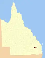 Location within Queensland | |||||||||||||||
| |||||||||||||||
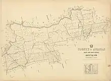
County of Auburn map, 2 miles to an inch, 1922
Parishes
Auburn is divided into parishes, as listed below:
| Parish | LGA | Coordinates |
|---|---|---|
| Athlone | Western Downs | 26°19′S 150°51′E |
| Ballon | Western Downs | 26°25′S 150°51′E |
| Bartsch | Western Downs | 26°30′S 150°07′E |
| Bembil | Western Downs | 26°14′S 150°57′E |
| Binkey | Western Downs | 26°21′S 150°11′E |
| Burraburri | Western Downs | 26°25′S 151°06′E |
| Delger | Western Downs | 26°19′S 151°03′E |
| Hookswood | Western Downs | 26°29′S 150°21′E |
| Macdonald | Western Downs | 26°21′S 150°40′E |
| Malcolm | Western Downs | 26°20′S 150°29′E |
| Pelham | Western Downs | 26°22′S 150°20′E |
| Quandong | Western Downs | 26°14′S 150°18′E |
| Wongongera | Western Downs | 26°32′S 150°31′E |
References
- "Auburn – county in Western Downs Region (entry 985)". Queensland Place Names. Queensland Government. Retrieved 28 November 2018.
- Darling Downs District, County of Auburn Maps – D2 Series at Queensland Archives.
External links
This article is issued from Wikipedia. The text is licensed under Creative Commons - Attribution - Sharealike. Additional terms may apply for the media files.