Crag Lough
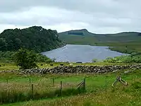
Crag Lough is an inland lake at the southern edge of Northumberland National Park, 2.5 miles (4.0 km) north of Bardon Mill, and 0.5 miles (0.8 km) north of the B6318 Military Road in Northumberland, northern England. At this point Hadrian's Wall is at the top of a line of crags, the Whin Sill, with Crag Lough at the foot of the crags.[1][2][3]
| Crag Lough | |
|---|---|
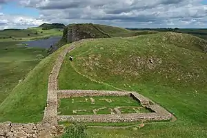 Milecastle 39 on Hadrian's Wall, with Crag Lough in the distance | |
 Crag Lough | |
| Location | Northumberland |
| Group | Roman Wall Loughs |
| Coordinates | 55.006°N 2.366°W |
| Type | Natural freshwater lake |
| Basin countries | England |
| Max. length | 1,970 feet (600 m) |
| Max. width | 425 feet (130 m) |
Etymology
The etymology of Crag Lough is linked to the Cumbric word luch, meaning 'lake' (c.f. Welsh lwch, Scottish Gaelic loch).[4] The 'Crag' element is probably from a word equivalent to Welsh graig, 'cliff'.
See also
References
- "3. Hadrian's Wall Walk Milecastle 39 Crag Lough Highshield Crags ..." docbrown.info. Retrieved 11 February 2014.
- "Crag Lough". fellingflyfishers.co.uk. Retrieved 11 February 2014.
- "Crag Lough, Northumberland" (PDF). opalexplorenature.org. Retrieved 11 February 2014.
- "Archived copy" (PDF). Archived from the original (PDF) on 2016-12-27. Retrieved 2016-12-26.CS1 maint: archived copy as title (link)
This article is issued from Wikipedia. The text is licensed under Creative Commons - Attribution - Sharealike. Additional terms may apply for the media files.
