Craigieburn Forest Park
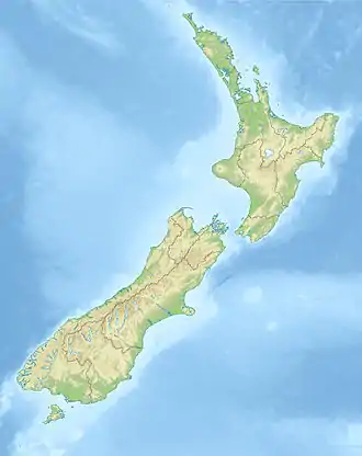
Craigieburn Forest Park is a 447 km2 (173 sq mi) protected area in the South Island of New Zealand, adjacent to Arthur's Pass National Park to the north.[1]
| Craigieburn Forest Park | |
|---|---|
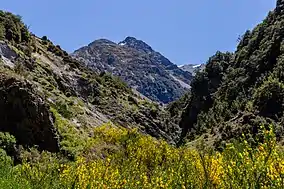 View to Black Range from Cass River | |
 Craigieburn Forest Park | |
| Location | South Island, New Zealand |
| Nearest city | Greymouth |
| Coordinates | 43.1527°S 171.7315°E |
| Area | 44,694.78 hectares (110,443.2 acres) |
| Governing body | Department of Conservation |
One of its boundaries lies in part alongside State Highway 73 and is adjacent to the eastern flanks of the Southern Alps.
The Broken River Ski Area and the Craigieburn Valley Ski Area lie within its borders. As with all other public land in New Zealand the Department of Conservation carries out administration for conservation and for regulating commercial activity.
Conservation
The New Zealand Forest Service had used the area as an experimental forestry area and there is now an environmental issue with the spread of wilding conifers.

See also
References
- "Data Table - Protected Areas - LINZ Data Service". Land Information New Zealand. Retrieved 18 October 2017.
This article is issued from Wikipedia. The text is licensed under Creative Commons - Attribution - Sharealike. Additional terms may apply for the media files.
