Creighton, Missouri
Creighton is a city in Cass County, Missouri, United States. The population was 349 at the 2010 census. It is part of the Kansas City metropolitan area.
Creighton, Missouri | |
|---|---|
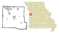 Location of Creighton, Missouri | |
| Coordinates: 38°29′44″N 94°4′23″W | |
| Country | United States |
| State | Missouri |
| County | Cass |
| Area | |
| • Total | 0.34 sq mi (0.89 km2) |
| • Land | 0.34 sq mi (0.89 km2) |
| • Water | 0.00 sq mi (0.00 km2) |
| Elevation | 787 ft (240 m) |
| Population | |
| • Total | 349 |
| • Estimate (2019)[3] | 342 |
| • Density | 991.30/sq mi (382.83/km2) |
| Time zone | UTC-6 (Central (CST)) |
| • Summer (DST) | UTC-5 (CDT) |
| FIPS code | 29-17164[4] |
| GNIS feature ID | 0716483[5] |
History
Creighton was platted in 1855, and named after John B. Creighton, a pioneer citizen.[6] A post office called Creighton has been in operation since 1887.[7]
Geography
Creighton is located at 38°29′44″N 94°4′23″W (38.495498, -94.073148).[8]
According to the United States Census Bureau, the city has a total area of 0.35 square miles (0.91 km2), all land.[9]
Demographics
| Historical population | |||
|---|---|---|---|
| Census | Pop. | %± | |
| 1890 | 308 | — | |
| 1900 | 360 | 16.9% | |
| 1910 | 400 | 11.1% | |
| 1920 | 335 | −16.2% | |
| 1930 | 289 | −13.7% | |
| 1940 | 272 | −5.9% | |
| 1950 | 269 | −1.1% | |
| 1960 | 228 | −15.2% | |
| 1970 | 294 | 28.9% | |
| 1980 | 301 | 2.4% | |
| 1990 | 289 | −4.0% | |
| 2000 | 322 | 11.4% | |
| 2010 | 349 | 8.4% | |
| 2019 (est.) | 342 | [3] | −2.0% |
| U.S. Decennial Census[10] | |||
2010 census
As of the census[2] of 2010, there were 349 people, 142 households, and 94 families living in the city. The population density was 997.1 inhabitants per square mile (385.0/km2). There were 160 housing units at an average density of 457.1 per square mile (176.5/km2). The racial makeup of the city was 95.7% White, 2.0% African American, 1.7% Native American, and 0.6% from two or more races. Hispanic or Latino of any race were 2.0% of the population.
There were 142 households, of which 35.9% had children under the age of 18 living with them, 47.9% were married couples living together, 9.9% had a female householder with no husband present, 8.5% had a male householder with no wife present, and 33.8% were non-families. 29.6% of all households were made up of individuals, and 11.3% had someone living alone who was 65 years of age or older. The average household size was 2.46 and the average family size was 3.02.
The median age in the city was 33.9 years. 25.8% of residents were under the age of 18; 9.5% were between the ages of 18 and 24; 26.6% were from 25 to 44; 25.2% were from 45 to 64; and 12.9% were 65 years of age or older. The gender makeup of the city was 48.7% male and 51.3% female.
2000 census
As of the census[4] of 2000, there were 322 people, 128 households, and 83 families living in the city. The population density was 1,086.7 people per square mile (414.4/km2). There were 138 housing units at an average density of 465.7 per square mile (177.6/km2). The racial makeup of the city was 98.76% White, 0.31% from other races, and 0.93% from two or more races. Hispanic or Latino of any race were 0.62% of the population.
There were 128 households, out of which 38.3% had children under the age of 18 living with them, 53.1% were married couples living together, 8.6% had a female householder with no husband present, and 34.4% were non-families. 31.3% of all households were made up of individuals, and 17.2% had someone living alone who was 65 years of age or older. The average household size was 2.52 and the average family size was 3.17.
In the city the population was spread out, with 31.1% under the age of 18, 5.9% from 18 to 24, 32.3% from 25 to 44, 16.8% from 45 to 64, and 14.0% who were 65 years of age or older. The median age was 35 years. For every 100 females, there were 105.1 males. For every 100 females age 18 and over, there were 101.8 males.
The median income for a household in the city was $41,071, and the median income for a family was $48,750. Males had a median income of $41,000 versus $19,479 for females. The per capita income for the city was $20,369. About 8.9% of families and 12.9% of the population were below the poverty line, including 11.7% of those under age 18 and 19.5% of those age 65 or over.
References
- "2019 U.S. Gazetteer Files". United States Census Bureau. Retrieved July 26, 2020.
- "U.S. Census website". United States Census Bureau. Retrieved 2012-07-08.
- "Population and Housing Unit Estimates". United States Census Bureau. May 24, 2020. Retrieved May 27, 2020.
- "U.S. Census website". United States Census Bureau. Retrieved 2008-01-31.
- "US Board on Geographic Names". United States Geological Survey. 2007-10-25. Retrieved 2008-01-31.
- "Cass County Place Names, 1928–1945 (archived)". The State Historical Society of Missouri. Archived from the original on 24 June 2016. Retrieved 16 September 2016.CS1 maint: bot: original URL status unknown (link)
- "Post Offices". Jim Forte Postal History. Archived from the original on 6 March 2016. Retrieved 16 September 2016.
- "US Gazetteer files: 2010, 2000, and 1990". United States Census Bureau. 2011-02-12. Retrieved 2011-04-23.
- "US Gazetteer files 2010". United States Census Bureau. Archived from the original on 2012-01-25. Retrieved 2012-07-08.
- "Census of Population and Housing". Census.gov. Retrieved June 4, 2015.
External links
- Historic maps of Creighton in the Sanborn Maps of Missouri Collection at the University of Missouri
Municipalities and communities of Cass County, Missouri, United States | ||
|---|---|---|
| Cities |  Map of Missouri highlighting Cass County | |
| Villages | ||
| Townships | ||
| Unincorporated communities | ||
| Ghost towns | ||
| Footnotes | ‡This populated place also has portions in an adjacent county or counties | |
| ||