Cumnock, North Carolina
Cumnock formerly known as Egypt[1] is an unincorporated community in northwestern Lee County, North Carolina, United States. It lies on Cumnock Road, about a mile north of U.S. Route 421.
Cumnock, North Carolina | |
|---|---|
 Cumnock  Cumnock | |
| Coordinates: | |
| Country | United States |
| State | North Carolina |
| County | Lee |
| Elevation | 272 ft (83 m) |
| Time zone | UTC-5 (Eastern (EST)) |
| • Summer (DST) | UTC-4 (EDT) |
| Area code(s) | 919 |
| GNIS feature ID | 1019884 |
Endor Iron Furnace is located near the community. It was listed on the National Register of Historic Places in 1974.[2] The Deep River Camelback Truss Bridge was listed in 1995.[2]
History
Egypt (now Cumnock) was the site of the Egypt Coal Mine which operated between 1855 and 1928.[3]
Geography
Cumnock is located at 35°33′18″N 79°14′16″W (35.5548727, -79.2377981), near the center of North Carolina.
External links
- Atlantic & Yadkin Railway
- U.S. Geological Survey Geographic Names Information System: Cumnock, North Carolina
- Margaret Wicker: The Coal Glen Mine Disaster (Mentions Egypt mine and Coal Glen mine)
- North Carolina Highway Historical Marker H-41 Egypt Coal Mine
- Escape NC Cumnock,NC
- Coal Deposits in the Deep River Field, Chatham, Lee, and Moore Counties, N.C.
- The Coal Glen Mine Disaster - a CACKLE cache
References
- Powell, William (1968). The North Carolina Gazetteer. Chapel Hill, North Carolina: University of North Carolina Press. p. 130.
- "National Register Information System". National Register of Historic Places. National Park Service. July 9, 2010.
- Powell, William (1968). The North Carolina Gazetteer. Chapel Hill, North Carolina: University of North Carolina Press. p. 130.
Municipalities and communities of Lee County, North Carolina, United States | ||
|---|---|---|
| City | 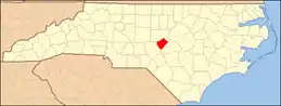 | |
| Town | ||
| Unincorporated communities | ||
| Footnotes | ‡This populated place also has portions in an adjacent county or counties | |
| ||
This article is issued from Wikipedia. The text is licensed under Creative Commons - Attribution - Sharealike. Additional terms may apply for the media files.
