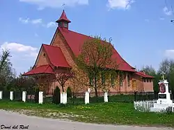
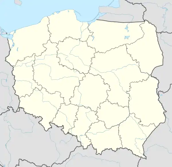
Długołęka, Świętokrzyskie Voivodeship
Długołęka[3][4] [dwuɡɔˈwɛnka] is a village in the administrative district of Gmina Osiek, within Staszów County, Świętokrzyskie Voivodeship, in south-central Poland. It lies approximately 4 kilometres (2 mi) east of Osiek, 24 km (15 mi) east of Staszów, and 75 km (47 mi) south-east of the regional capital Kielce.[5]
Długołęka | |
|---|---|
Village | |
 | |
 Długołęka | |
| Coordinates: 50°31′09″N 21°30′10″E | |
| Country | Poland |
| Voivodeship | Świętokrzyskie |
| County | Staszów |
| Gmina | Osiek |
| Sołectwo | Długołęka[1] |
| Part of village | Villageship List
|
| Elevation | 149 m (489 ft) |
| Population (31 December 2009 at Census)[2] | |
| • Total | |
| Time zone | UTC+1 (CET) |
| • Summer (DST) | UTC+2 (CEST) |
| Postal code | 28-221 |
| Area code(s) | +48 15 |
| Car plates | TSZ |
The village has a population of ![]() 343.
343.
Demography
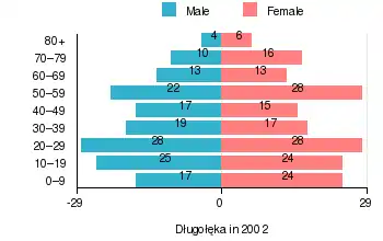
According to the 2002 Poland census, there were 326 people residing in Długołęka village, of whom 47.5% were male and 52.5% were female. In the village, the population was spread out, with 24.2% under the age of 18, 35.9% from 18 to 44, 23% from 45 to 64, and 16.9% who were 65 years of age or older.[2]
Table 1. Population level of village in 2002 – by age group[2] SPECIFICATION Measure
unitPOPULATION
(by age group in 2002)TOTAL 0–9 10–19 20–29 30–39 40–49 50–59 60–69 70–79 80 + I. TOTAL person 326 41 49 56 36 32 50 26 26 10 — of which in % 100 12.6 15.1 17.2 11 9.8 15.3 8 8 3 1. BY SEX A. Males person 155 17 25 28 19 17 22 13 10 4 — of which in % 47.5 5.2 7.7 8.6 5.8 5.2 6.7 4 3.1 1.2 B. Females person 171 24 24 28 17 15 28 13 16 6 — of which in % 52.5 7.4 7.4 8.6 5.2 4.6 8.6 4 4.9 1.8
Figure 1. Population pyramid of village in 2002 — by age group and sex[2]
Table 2. Population level of village in 2002 – by sex[2] SPECIFICATION Measure
unitPOPULATION
(by sex in 2002)TOTAL Males Females I. TOTAL person 326 155 171 — of which in % 100 47.5 52.5 1. BY AGE GROUP A. At pre-working age person 79 37 42 — of which in % 24.2 11.3 12.9 B. At working age, grand total person 192 98 94 — of which in % 58.9 30.1 28.8 a. at mobile working age person 117 60 57 — of which in % 35.9 18.4 17.5 b. at non-mobile working age person 75 38 37 — of which in % 23 11.7 11.3 C. At post-working age person 55 20 35 — of which in % 16.9 6.1 10.8
Former parts of village – physiographic objects
In the years 1970 of last age, sorted and prepared out list part of names of localities for Długołęka, what you can see in table 3.
Table 3. Index of official names of localities and physiographic objects[6] Names of village – town Names of part of village
— townNames of physiographic objects
— nature of objectsI. Gromada OSIEK
- Długołęka
- Otoczyna
- Otoka Gągolińska
- Błonie – field
- Długołęckie – field
- Dodawki – field, meadow, wasteland
- Karczma – pond
- Kępa – meadow, bushes
- Kowalówka – field
- Olszyny – meadow, bushes, wasteland
- Otockie – field
- Plewiny – field
- Żabieniec – meadow
References
- Rękas, Przemysław (16 January 2012). "Wykaz sołectw Gminy Osiek" [List of sołectwos of Commune and Municipality Office of Osiek]. The administrative power / An estate in Osiek and index of sołectwos (in Polish). Public Information Bulletin of Commune and Municipality Office of Osiek, Poland. bip.osiek.iap.pl. Retrieved 19 January 2012.
- "Local Data Bank (Bank Danych Lokalnych) – Layout by NTS nomenclature (Układ wg klasyfikacji NTS)". demografia.stat.gov.pl: GUS. 10 March 2011.
- Bielec, Jan (ed.); Szwałek, Stanisława (1980). Wykaz urzędowych nazw miejscowości w Polsce. T. I: A – J [List of official names of localities in Poland, Vol. I: A – J] (in Polish). Ministry of Administration, Spatial Economy and Environmental Protection (1st ed.). Warsaw, Poland: Central Statistical Office.CS1 maint: extra text: authors list (link)
- "Długołęka, wieś, gmina Osiek – obszar wiejski, powiat staszowski, województwo świętokrzyskie" [Długołęka, village, Osiek Commune – rural area, Staszów County, Świętokrzyskie Province, Poland]. Topographical map prepared in 1:10,000 scale. Aerial and satellite orthophotomap (in Polish). Head Office of Geodesy and Cartography, Poland, Warsaw. 2011. geoportal.gov.pl. Retrieved 27 April 2011.
- "Central Statistical Office (GUS) – TERYT (National Register of Territorial Land Apportionment Journal)" (in Polish). 1 June 2008.
- Cf. Kaczmarek, Leon (ed.); Taszycki, Witold (1970). Urzędowe nazwy miejscowości i obiektów fizjograficznych. 33. Powiat staszowski województwo kieleckie [Official Names of Localities and Physiographic Objects. 33. Staszów County Kielce Voivodeship] (in Polish). Commission for Establishing Names of Localities and Physiographic Objects (to business use). Vol. 33. Warsaw, Poland: Council of Ministers' Office. Cabinet Office for bureaux of the Supervisory Boards. pp. 28, 77–78, 81–82, 86–87, 96.CS1 maint: extra text: authors list (link)
| Town and seat |  | ||||
|---|---|---|---|---|---|
| Parts of town |
| ||||
| Villages |
| ||||
| Parts of village |
| ||||
| Colony | |||||
| Hamlet |
| ||||
| Smaller locality |
| ||||