D26 road (Croatia)
D26 is a state road in central Croatia connecting the D5 in Daruvar and the D10 expressway near Vrbovec (Dubrava interchange),[maps 1] comprising a connection to the planned but cancelled A12 motorway route.[1][2] The road is 88.5 km (55.0 mi) long.[3]
| |
|---|---|
| Route information | |
| Length | 88.5 km (55.0 mi) |
| Major junctions | |
| From | |
| To | |
| Location | |
| Counties | Zagreb County, Bjelovar-Bilogora |
| Major cities | Vrbovec, Čazma, Garešnica, Daruvar. |
| Highway system | |
| State roads in Croatia | |

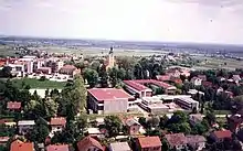
Vrbovec, near the western terminus of the D26 road
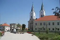
Čazma, on the D26 road route
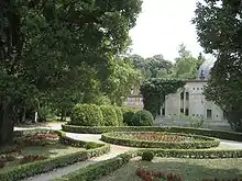
Daruvar, at the eastern terminus of the D26 road
The road, as well as all other state roads in Croatia, is managed and maintained by Hrvatske ceste, a state owned company.[4]
Traffic volume
Traffic is regularly counted and reported by Hrvatske ceste, operator of the road.[5]
| D26 traffic volume | ||||
| Road | Counting site | AADT | ASDT | Notes |
| 2036 Konak | 2,409 | 2,444 | Adjacent to the Dubrava interchange (D10). | |
| 2111 Čazma - east | 1,524 | 1,625 | Adjacent to the L37056 junction. | |
| 2112 Trnovitički Popovac | 1,231 | 1,298 | Adjacent to the D45 junction. | |
| 2128 Garešnica | 5,155 | 5,168 | Between the Ž3165 and D45 junctions. | |
| 2211 Hrastovac | 1,302 | 1,393 | Adjacent to the Ž3168 junction. | |
| 2218 Uljanik | 1,140 | 1,196 | Adjacent to the L37145 junction. | |
Road junctions and populated areas
| D26 junctions/populated areas | |
| Type | Slip roads/Notes |
| Dubrava interchange Ž3288 to Vrbovec, Rakovec and Sveti Ivan Zelina (D3). The western terminus of the road. | |
| Koritna | |
| Ladina | |
| Dubrava Ž2211 to Cugovec, Poljana Križevačka and Cubinec (D22). Ž3401 to Ivanić Grad (to the south) and to Haganj (D28) (to the north). | |
| Zgališće | |
| Bađinec | |
| Svinjarec | |
| Donji Dragičevci | |
| Cerina Ž3284 to Donji Lipovčani, Marčani and Sovari (D43). | |
| Čazma Ž3128 to Rečica Kriška. | |
| Grabovnica | |
| Vučani | |
| Donji Miklouš Ž3082 to Martinac and Donja Šušnjara. | |
| Šimljanik | |
| Gornja Garešnica Ž3131 to Gornja Jelenska and Pobrđe. | |
| Trnovitički Popovac | |
| Ž3084 to Begovača, Berek, Ivanska and Paljevine. | |
| Mali Pašijan | |
| Veliki Pašijan Ž3090 to Velika Trnovitica and Nova Rača. | |
The D26 and D45 are concurrent to the south. | |
| Garešnica The D26 and D45 are concurrent to the north. Ž3136 to Tomašica and Veliki Zdenci (D5). Ž3167 to Kaniška Iva and Međurić. Ž3165 to Dišnik. | |
| Hrastovac | |
| Uljanik Ž3168 to Poljana, Međurić and Banova Jaruga. | |
| Blagorodovac | |
| Dežanovac Ž3138 to Končanica (D5). Ž3169 to Trojeglava and Badljevina (D5). Ž3281 to Kreštelovac and Sokolovac. | |
| Ivanovo Polje | |
| Gornji Daruvar | |
| Daruvar Ž3287 within the city. The eastern terminus of the road. | |
Maps
- Overview map of the D26 (Map). OpenStreetMap. Retrieved July 21, 2014.
Sources
- "Regulation on motorway markings, chainage, interchange/exit/rest area numbers and names". Narodne novine (in Croatian). April 24, 2003. Archived from the original on October 4, 2011. Retrieved August 13, 2010.
- Andreja Žapčić (20 June 2012). "Vlada HAC-u odobrila novi kredit od 120 milijuna eura" [Government approves a new 120 million Euro loan to the Hrvatske autoceste] (in Croatian). t-portal.hr. Retrieved 24 June 2012.
- "Decision on categorization of public roads as state roads, county roads and local roads". Narodne novine (in Croatian). February 17, 2010.
- "Public Roads Act". Narodne novine (in Croatian). December 14, 2004.
- "Brojenje prometa na cestama Republike Hrvatske godine 2015" [Traffic counting on the roadways of Croatia in 2015] (PDF) (in Croatian). Hrvatske ceste. April 2016. Archived from the original (PDF) on 2016-07-01. Retrieved 2016-06-23.
This article is issued from Wikipedia. The text is licensed under Creative Commons - Attribution - Sharealike. Additional terms may apply for the media files.