Dargun
Dargun is a town in the Mecklenburgische Seenplatte district, in Mecklenburg-Western Pomerania, Germany.[2] It is situated 12 km (7 mi) km west of Demmin.[3] It is famous for Dargun Palace, a former Cistercian abbey.[4]
Dargun | |
|---|---|
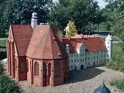 Model of Dargun Abbey and Palace prior to destruction in WW2 | |
 Coat of arms | |
Location of Dargun within Mecklenburgische Seenplatte district 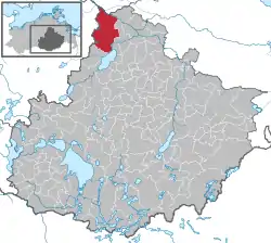 | |
 Dargun  Dargun | |
| Coordinates: 53°53′N 12°50′E | |
| Country | Germany |
| State | Mecklenburg-Vorpommern |
| District | Mecklenburgische Seenplatte |
| Subdivisions | 19 |
| Government | |
| • Mayor | Karl-Heinz Graupmann |
| Area | |
| • Total | 117.15 km2 (45.23 sq mi) |
| Elevation | 10 m (30 ft) |
| Population (2019-12-31)[1] | |
| • Total | 4,329 |
| • Density | 37/km2 (96/sq mi) |
| Time zone | UTC+01:00 (CET) |
| • Summer (DST) | UTC+02:00 (CEST) |
| Postal codes | 17159 |
| Dialling codes | 039959 |
| Vehicle registration | DM |
| Website | www.dargun.de |
History
From 1815 to 1918 Dargun was part of the Grand Duchy of Mecklenburg-Schwerin.[5] The Palace was burned down by Red Army soldiers after the conquest of the town in late April 1945.[6]
References
- "Statistisches Amt M-V – Bevölkerungsstand der Kreise, Ämter und Gemeinden 2019". Statistisches Amt Mecklenburg-Vorpommern (in German). July 2020.
- "Dargun, Germany Weather Conditions | Weather Underground". www.wunderground.com. Retrieved 2020-10-29.
- "Demmin - Dargun route planner - distance, time and costs – ViaMichelin". www.viamichelin.com. Retrieved 2020-10-29.
- "Monastery: Staatliche Schlösser und Gärten Baden-Württemberg". www.salem.de. Retrieved 2020-10-29.
- www.ancestry.com https://www.ancestry.com/search/collections/1167/. Retrieved 2020-10-29. Missing or empty
|title=(help) - Joachim Schultz-Naumann (1990), Universitas Verlag (ed.), Mecklenburg 1945 (in German), p. 199, ISBN 3-8004-1215-2
External links
![]() Media related to Dargun at Wikimedia Commons
Media related to Dargun at Wikimedia Commons
| Authority control |
|---|
This article is issued from Wikipedia. The text is licensed under Creative Commons - Attribution - Sharealike. Additional terms may apply for the media files.