Darlington, Maryland
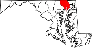
Darlington is an unincorporated community and census-designated place in northeastern Harford County, Maryland, United States.[1] The population was 409 at the 2010 census.[2] The center of the community was listed on the National Register of Historic Places as the Darlington Historic District in 1987. Median household income is $66,563. The percentage of people in poverty is 5.3%.
Darlington, Maryland | |
|---|---|
 Darlington  Darlington | |
| Coordinates: 39°38′21″N 76°12′10″W | |
| Country | United States |
| State | Maryland |
| County | Harford |
| Area | |
| • Total | 1.05 sq mi (2.72 km2) |
| • Land | 1.05 sq mi (2.72 km2) |
| • Water | 0.0 sq mi (0.0 km2) |
| Elevation | 330 ft (100 m) |
| Population (2010) | |
| • Total | 409 |
| • Density | 390/sq mi (150.5/km2) |
| Time zone | UTC−5 (Eastern (EST)) |
| • Summer (DST) | UTC−4 (EDT) |
| FIPS code | 24-21800 |
Geography
Darlington is located in northeastern Harford County at 39°30′10″N 76°19′8″W (39.502757, −76.318971),[3] along Maryland Route 161. U.S. Route 1 crosses the northern side of the community, leading northeast 65 miles (105 km) to Philadelphia and southwest 35 miles (56 km) to Baltimore. Route 1 crosses the Susquehanna River at Conowingo Dam, 2 miles (3 km) northeast of Darlington. Havre de Grace is 11 miles (18 km) to the southeast via Routes 161 and 155.
According to the United States Census Bureau, the Darlington CDP has a total area of 1.05 square miles (2.72 km2), all land.[2]
Historic sites
The southern part of the CDP, south of Shuresville Road, is part of the Darlington Historic District, listed on the National Register of Historic Places (NRHP) in 1987. There are approximately 100 contributing properties, including buildings by architects such as Theophilus Parsons Chandler, Jr. and Walter Cope. The village was also home to Harry Webb Farrington.
Other sites listed on the NRHP in the community and surrounding region are the Deer Creek Friends Meetinghouse along Main Street near US 1; Berkley Crossroads Historic District and Berkley School, less than 1 mile (1.6 km) north of Darlington on Maryland Route 623; Gray Gables and Wildfell, less than 1 mile to the northwest on US 1; the Lower Deer Creek Valley Historic District, 3 miles (5 km) to the southwest; and the Silver Houses Historic District, 2.5 miles (4.0 km) south of town on Route 161.
History
There is evidence for settlement in the town around 1700, but not much before that time. Darlington had a stagecoach line to Baltimore and a lot of traffic from the Susquehanna and the Tidewater Canal had to go through it.
The Darlington Academy was built in 1836 and used to be a popular school in Harford County. Additionally, almost 100 years later in 1928 the Conowingo Dam was built and made it easier to travel across.
Community

Local children attend the Darlington Elementary School near the center of town. The elementary school has one class per grade level (K through 5), and two autism classrooms. There is no high school in Darlington, so students usually enroll in Havre De Grace High School.[4]
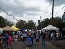
An annual apple festival is held in Darlington the first Saturday in October, and attracts almost 60,000 people.[1]
Darlington and the surrounding communities are provided fire and EMS service by the Darlington Volunteer Fire Company.
Darlington has its own library at 1134 Main Street. Darlington also has several houses of worship, including Franklin Baptist Church, Harmony Presbyterian Church, Grace Episcopal Church, Darlington United Methodist Church, Deer Creek Friends Meetinghouse, and Hosanna AME Church located in historic Berkley, Maryland.
Photos of Darlington
 View of Darlington
 The old Kirk House
 Deer Creek Friends Meetinghouse
 Darlington village
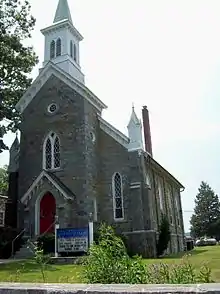
 Grace Memorial Episcopal Church (1876–78), Theophilus Parsons Chandler, Jr., architect
 Darlington Methodist Church
 Darlington Elementary School
 Harmony Presbyterian Church
 Lloyd's Store
References
- The Darlington Apple Festival, Darlington Apple Festival. Accessed 2007-11-26.
- "Geographic Identifiers: 2010 Demographic Profile Data (G001): Darlington CDP, Maryland". American Factfinder. U.S. Census Bureau. Retrieved July 13, 2017.
- "US Gazetteer files: 2010, 2000, and 1990". United States Census Bureau. 2011-02-12. Retrieved 2011-04-23.
- Darlington Elementary School, GreatSchools.net, 2007. Accessed 2007-11-26.
External links
- Darlington Historic District, Harford County, Maryland Historical Trust
