Daurian forest steppe
The Daurian forest steppe ecoregion (WWF ID:PA0804) is a band of grassland, shrub terrain, and mixed forests in northeast Mongolia and the region of Siberia, Russia that follows the course of the Onon River and Ulz River. The region has been described as a “sea of grass that forms the best and most intact example of an undisturbed steppe ecosystem and is also one of the last areas in the Palearctic that still supports stable herds of larger vertebrates” in a semi-mountainous area.[1] The area also has flat wetlands that are important to migratory birds. The ecoregion is in the Palearctic realm, with a Cold semi-arid climate. It covers 209,012 km2 (80,700 sq mi).[2]
| Ecoregion: Daurian Forest steppe | |
|---|---|
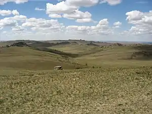 Daursky Nature Reserve in the ecoregion | |
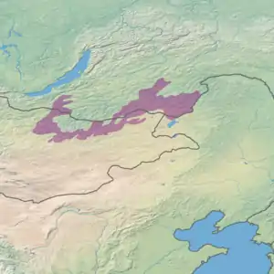 Ecoregion territory (in purple) | |
| Ecology | |
| Realm | Palearctic |
| Biome | temperate grasslands, savannas, and shrublands |
| Geography | |
| Countries | Mongolia, Russia and China |
Location and description
The ecoregion circles around half of the Khentii Mountains, then stretches over 1,000 kilometers east of Ulan Bator into northeasteastern Mongolia through the semi-arid region south and east of Chita, Zabaykalsky Krai, Russia. A prominent feature is the Onon River flowing east through mid-sized mountains (1,400 - 1,800 meters in height) to the Amur River.[3][4]
Climate
Because of its altitude and distance from the ocean, the ecoregion has a Subarctic climate (Köppen climate classification Dwc). This indicates a continental climate characterized by short, cool summers, and very cold, long winters, with wide differences between day and night temperatures. This region is also heavily influenced by the high barometric pressures over Mongolia. Mean temperatures range from -30° C (January) to +24° C (August). Average annual precipitation is 150 mm.
| Climate at 49.75 N, 112.75 E | ||||||||||||||||||||||||||||||||||||||||||||||||||||||||||||
|---|---|---|---|---|---|---|---|---|---|---|---|---|---|---|---|---|---|---|---|---|---|---|---|---|---|---|---|---|---|---|---|---|---|---|---|---|---|---|---|---|---|---|---|---|---|---|---|---|---|---|---|---|---|---|---|---|---|---|---|---|
| Climate chart (explanation) | ||||||||||||||||||||||||||||||||||||||||||||||||||||||||||||
| ||||||||||||||||||||||||||||||||||||||||||||||||||||||||||||
| ||||||||||||||||||||||||||||||||||||||||||||||||||||||||||||
Flora and fauna
The steppe lands of the ecoregion are characterized by sedges (family Carex) and grasses (family Poaceae), forming meadow steppe, herbs steppe and sandy saltmarsh steppe. Along the lake shores are salt-loving plants and reed beds. The forests of the area are mostly Asian black birch (Betula dahurica), Scots pine (Pinus sylvestris), and Siberian larch (Larix sibirica). Aspen groves are found in some mountain areas.
Herds of Mongolian Gazelle (Procapra gutturosa) roam the grasslands of the region, which is at the northern edge of their territory. The broken terrain of mountains and ravines support small mammals, including the Lesser white-toothed shrew (Crocidura sauveolens), Eurasian harvest mouse (Micromys minutus), and Maximowicz's vole (Microtus maximowiczii). Predators include the wolf, polecat, Eurasian badger, and Pallas's cat (Otocolobus manul).
Protections
The federally protected areas in the region are:
- Alkhanay National Park. An IUCN class II National Park located in the Zabaykalsky Krai region of southern Siberia, covering a forested, mountainous area surrounded by steppe terrain. (Area: 1,382 km2).
- Daursky Nature Reserve. An IUCN class Ia "strict ecological reserve" (a Zapovednik) located on the border of Russia and Mongolia, protecting wetlands and lakes. It is part of a World Heritage Site named "The Landscapes of Dauria".[6] (Area: 84,290 km2).
References
- "Daurian forest steppe". Encyclopedia of Earth.
- "Daurian forest steppe". Ecoregions of the World. GlobalSpecies.org. Archived from the original on June 24, 2018. Retrieved June 22, 2018.
- "Eastern Asia: China, northeastern Mongolia, and Russia". World Wildlife Federation. Retrieved June 22, 2018.
- ""Dauria"". Amur Information Center. Retrieved June 22, 2018.
- "Climate, 49.75/112.75". GlobalSpecies.org. Archived from the original on June 24, 2018. Retrieved June 22, 2018.
- https://whc.unesco.org/en/list/1448/indicators/
