De Loonse en Drunense Duinen National Park
De Loonse en Drunense Duinen National Park (duinen = dunes) is a national park situated in the south of the Netherlands, between the cities of Tilburg, Waalwijk and 's-Hertogenbosch. It has been designated as a national park since 2002. It is 35 km² (14 mile²) in area, and located in the municipalities of Loon op Zand, Heusden, and Vught.
| De Loonse en Drunense Duinen National Park | |
|---|---|
| Nationaal Park De Loonse en Drunense Duinen | |
IUCN category II (national park) | |
Aerial video of the Loonse en Drunese Duinen area. | |
| Location | North Brabant, Netherlands |
| Coordinates | 51°38′52″N 5°06′53″E |
| Area | 35 km2 (14 sq mi) |
| Established | 2002[1] |
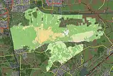
Detailmap
Loonse en Drunense Duinen
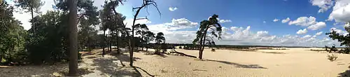
The Loonse en Drunense Duinen consists of forests and very large dunes, creating an extraordinary microclimate.
References
- (in Dutch) http://www.nationaalpark.nl/ldd/ Nationaal park Loonse en Drunense Duinen
This article is issued from Wikipedia. The text is licensed under Creative Commons - Attribution - Sharealike. Additional terms may apply for the media files.