De Smet, Idaho
De Smet (also spelled Desmet) is an unincorporated census-designated place in the northwestern United States, located on the Coeur d'Alene Reservation in Benewah County, Idaho.
De Smet, Idaho | |
|---|---|
Census-designated place | |
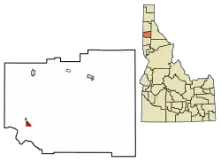 Location of De Smet in Benewah County, Idaho. | |
 De Smet, Idaho Location of De Smet in Benewah County, Idaho. | |
| Coordinates: 47°08′46″N 116°54′57″W | |
| Country | United States |
| State | Idaho |
| County | Benewah |
| Area | |
| • Total | 0.957 sq mi (2.48 km2) |
| • Land | 0.957 sq mi (2.48 km2) |
| • Water | 0 sq mi (0 km2) |
| Elevation | 2,598 ft (792 m) |
| Population (2010) | |
| • Total | 175 |
| • Density | 180/sq mi (71/km2) |
| Time zone | UTC-8 (Pacific (PST)) |
| • Summer (DST) | UTC-7 (PDT) |
| ZIP code | 83824 |
| Area code(s) | 208, 986 |
| GNIS feature ID | 397609[1] |
U.S. Route 95 passes nearby and the community is located about a mile (1.6 km) south of Tensed, which was originally Temsed (De Smet spelled backwards). De Smet has a post office with a ZIP code of 83824.[2] As of the 2010 census, its population was 175,[3] and its elevation is approximately 2,600 feet (790 m) above sea level.
It was named for the Belgian Catholic priest Pierre De Smet,[4] a 19th-century Jesuit missionary. He worked with the Coeur d'Alène and other native peoples of western North America for most of his life, periodically returning to his chapter based in St. Louis, Missouri.
Climate
This region has warm (but not hot) and dry summers, with no average monthly temperatures above 71.6 °F. According to the Köppen Climate Classification system, De Smet has a warm-summer Mediterranean climate, abbreviated "Csb" on climate maps.[6]
See also
References
- U.S. Geological Survey Geographic Names Information System: De Smet, Idaho
- ZIP Code Lookup
- "U.S. Census website". U.S. Census Bureau. Retrieved 22 March 2011.
- Gannett, Henry (1905). The Origin of Certain Place Names in the United States. Govt. Print. Off. pp. 105.
- "Census of Population and Housing". Census.gov. Retrieved June 4, 2016.
- Climate Summary for De Smet, Idaho
Municipalities and communities of Benewah County, Idaho, United States | ||
|---|---|---|
| Cities | Map of Idaho highlighting Benewah County | |
| CDPs | ||
| Unincorporated communities | ||
| Indian reservation | ||
| Footnotes | ‡This populated place also has portions in an adjacent county or counties | |
| ||
| Authority control |
|
|---|