Delaware Route 18
Delaware Route 18 (DE 18) is a state highway located in Sussex County, Delaware. It runs from Maryland Route 318 (MD 318) at the Maryland border east of Federalsburg, Maryland to U.S. Route 9 (US 9) in Georgetown. DE 18 runs concurrent with DE 404 from its intersection with that highway southeast of Bridgeville to the eastern terminus, where DE 404 continues eastward to Five Points on US 9. The route passes through rural areas of western Sussex County. What would become DE 18 was built as a state highway in stages during the 1920s and 1930s. By 1936, DE 18 was designated to run from the Maryland border east through Georgetown to Lewes. In 1974, the route east of Georgetown was replaced by US 9 and US 9 Business (US 9 Bus.). DE 404 was designated along the eastern portion of DE 18 by 1987.
| ||||
|---|---|---|---|---|
 | ||||
| Route information | ||||
| Maintained by DelDOT | ||||
| Length | 19.35 mi[1] (31.14 km) | |||
| Existed | 1936[2]–present | |||
| Major junctions | ||||
| West end | ||||
| East end | ||||
| Location | ||||
| Counties | Sussex | |||
| Highway system | ||||
| ||||

Route description
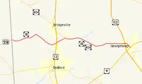
DE 18 begins at the Maryland border, where the road continues west into that state as MD 318. From the state line, the route heads east on two-lane undivided Federalsburg Road, passing through agricultural areas with some woods and homes. The road runs through the community of Atlanta, where it crosses Atlanta Road. In the community of Clarksons Crossroads, DE 18 turns southeast onto Cannon Road while Federalsburg Road continues northeast toward the town of Bridgeville. The road continues to the community of Cannon, where it crosses the Delmarva Central Railroad's Delmarva Subdivision line at-grade. East of Cannon, the route crosses Clear Brook before it comes to an intersection with US 13. Following this, DE 18 heads northeast through farm fields, reaching a junction with DE 404.[3][4]
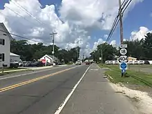
At this point, DE 18 heads east concurrent with DE 404 along Seashore Highway through a mix of farmland and woodland with some residences. The road crosses the Nanticoke River and passes through tracts of the Redden State Forest, heading across Gravelly Branch to the south of Collins Pond and crossing Deep Creek further east. DE 18/DE 404 enters the town of Georgetown and becomes Bridgeville Road, running to the north of the Jack F. Owens Campus of Delaware Technical Community College. The road intersects US 113 and the western terminus of DE 404 Truck in a commercial area and continues east. The two routes head southeast onto North Bedford Street, passing homes and businesses. The road intersects US 9 at a traffic circle called The Circle in the center of Georgetown, where the Sussex County Courthouse is located. At this point, DE 18 ends and DE 404 continues east along US 9.[3][4]
The section of DE 18 concurrent with DE 404 serves as part of a primary hurricane evacuation route from the Delaware Beaches to points inland.[5] DE 18 has an annual average daily traffic count ranging from a high of 20,266 vehicles at the US 113 intersection to a low of 2,128 vehicles at the US 13 intersection.[1] The portion of DE 18 concurrent with DE 404 is part of the National Highway System.[6]
History
By 1920, what would eventually become DE 18 was under contract as a state highway from southeast of Bridgeville to Georgetown and from Georgetown to Harbeson; the remainder existed as an unimproved county road.[7] The state highway was completed between Cannon and present-day US 13 and from southeast of Bridgeville east to Lewes by 1924, with the exception of a portion within Georgetown. The part of present-day DE 18 west of Clarksons Crossroads was under proposal as a state highway by this time also.[8] A year later, the portions of the route west of Clarksons Crossroads and within Georgetown were upgraded to state highway status.[9] In 1927, plans were made to replace the 1914-built county-maintained bascule bridge over the Lewes and Rehoboth Canal in Lewes.[10][11] Replacement of this bridge by the state was completed in 1929.[11] By 1931, the state highway was finished between Clarksons Crossroads and Cannon.[12] The portion of road from US 13 east to the current west end of the DE 404 concurrency was completed as a state highway a year later.[13]
DE 18 was designated to run from the Maryland border west of Cannon east to Lewes Beach on the Delaware Bay by 1936, following its current alignment east to Georgetown and continuing east through Gravel Hill, Harbeson, and Lewes.[2] In 1974, the eastern terminus of DE 18 was cut back to its current location in Georgetown, with an extended US 9 replacing the route between Georgetown and Five Points and US 9 Bus. replacing DE 18 from Five Points to Lewes.[14][15] DE 404 was extended to run concurrent with DE 18 from east of Bridgevillle to Georgetown by 1987.[16]
Major intersections
The entire route is in Sussex County.
| Location | mi[1] | km | Destinations | Notes |
|---|---|---|---|---|
| | 0.00 | 0.00 | Maryland state line; western terminus | |
| Cannon | 7.56 | 12.17 | ||
| | 9.06 | 14.58 | West end of DE 404 overlap | |
| Georgetown | 18.33 | 29.50 | Western terminus of DE 404 Truck | |
| 19.35 | 31.14 | Traffic circle; eastern terminus | ||
1.000 mi = 1.609 km; 1.000 km = 0.621 mi
| ||||
See also
 U.S. Roads portal
References
- Staff (2018). "Traffic Count and Mileage Report: Interstate, Delaware, and US Routes" (PDF). Delaware Department of Transportation. Retrieved March 29, 2020.
- Delaware State Highway Department; The National Survey Co. (1936). Official Road Map of the State of Delaware (PDF) (Map) (1936–1937 ed.). Dover: Delaware State Highway Department. Retrieved November 24, 2015.
- Delaware Department of Transportation (2017). Official Travel & Transportation Map (PDF) (Map). Dover: Delaware Department of Transportation. Retrieved August 18, 2019.
- Google (September 2, 2010). "overview of Delaware Route 18" (Map). Google Maps. Google. Retrieved September 2, 2010.
- Delmarva Peninsula Evacuation Route Map (PDF) (Map). Delaware Department of Transportation. Retrieved March 22, 2017.
- National Highway System: Delaware (PDF) (Map). Federal Highway Administration. 2010. Retrieved February 10, 2012.
- Delaware State Highway Department (1920). Official Road Map (PDF) (Map). Dover: Delaware State Highway Department. Retrieved November 24, 2015.
- Delaware State Highway Department (1924). Official Road Map (PDF) (Map). Dover: Delaware State Highway Department. Retrieved November 24, 2015.
- Delaware State Highway Department (1925). Official Road Map (PDF) (Map). Dover: Delaware State Highway Department. Retrieved November 24, 2015.
- "Annual Report of the State Highway Department" (PDF) (1927 ed.). Dover, Delaware: Delaware State Highway Department. December 31, 1927: 8. Retrieved November 16, 2014. Cite journal requires
|journal=(help) - "Annual Report of the State Highway Department" (PDF) (1929 ed.). Dover, Delaware: Delaware State Highway Department. December 31, 1929: 11. Retrieved November 16, 2014. Cite journal requires
|journal=(help) - Delaware State Highway Department (1931). Official Road Map of the State of Delaware (PDF) (Map). Dover: Delaware State Highway Department. Retrieved November 24, 2015.
- Delaware State Highway Department (1932). Official Road Map (PDF) (Map). Dover: Delaware State Highway Department. Retrieved November 24, 2015.
- U.S. Route Numbering Subcommittee (June 25, 1974). "U.S. Route Numbering Subcommittee Agenda" (Report). Washington, DC: American Association of State Highway and Transportation Officials. p. 448. Retrieved October 16, 2014 – via Wikisource.
- Delaware Department of Highways and Transportation (1976). Delaware Highways Official Map (PDF) (Map). Dover: Delaware Department of Highways and Transportation. Retrieved November 24, 2015.
- Delaware Department of Transportation (1987). Official State Highway Map (PDF) (Map). Dover: Delaware Department of Transportation. Retrieved November 24, 2015.
