Desaguadero River (Bolivia)
The Desaguadero River in Bolivia drains Lake Titicaca from the southern part of the river basin, flowing south and draining approximately five percent of the lake's flood waters into Lake Uru Uru and Lake Poopó.[1] Its source in the north is very near the Peruvian border.
| Desaguadero | |
|---|---|
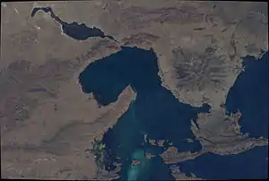 The Desaguadero River at its origin as seen from the ISS (upper center, left; north is to the lower right part of this image) | |
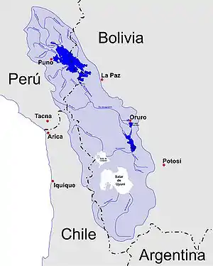 Sketch map of the area showing Desaguadero River | |
| Location | |
| Country | Peru, Bolivia |
| Region | Altiplano |
| Cities | Desaguadero, San Andrés, Oruro |
| Physical characteristics | |
| Source | Lake Titicaca |
| • location | Desaguadero, Peru |
| • coordinates | 16°33′49″S 69°02′11″W |
| • elevation | 3,811 m (12,503 ft) |
| Mouth | Poopó Lake |
• location | 50 kilometres (31 mi) S of Oruro, Bolivia |
• coordinates | 18°26′31″S 67°04′22″W |
• elevation | 3,686 m (12,093 ft) |
| Length | 320 km (200 mi) |
| Basin size | 90,000 km2 (35,000 sq mi)approx. |
| Discharge | |
| • location | Ulloma |
| • average | 78 m3/s (2,800 cu ft/s) |
| • minimum | 28 m3/s (990 cu ft/s) |
| • maximum | 282 m3/s (10,000 cu ft/s) |
| Basin features | |
| Tributaries | |
| • left | Ch'alla Jawira, Llallawa Jawira, Jach'a Jawira (Caquiaviri), Thujsa Jawira, Qala Jawira, Jach'a Jawira (Ingavi) |
| • right | Qullpa Jawira |
It is navigable only by small craft and supports indigenous communities such as the Uru Muratu community.
See also
Notes
- "Desaguadero River (river, Bolivia)". Encyclopædia Britannica. Retrieved 2007-07-12.
This article is issued from Wikipedia. The text is licensed under Creative Commons - Attribution - Sharealike. Additional terms may apply for the media files.