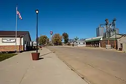
Diagonal, Iowa
Diagonal is a city in Ringgold County, Iowa, United States. The population was 330 at the 2010 census.
Diagonal, Iowa | |
|---|---|
 | |
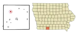 Location of Diagonal, Iowa | |
| Coordinates: 40°48′32″N 94°20′29″W | |
| Country | |
| State | |
| County | Ringgold |
| Area | |
| • Total | 0.91 sq mi (2.35 km2) |
| • Land | 0.90 sq mi (2.34 km2) |
| • Water | 0.00 sq mi (0.00 km2) |
| Elevation | 1,148 ft (350 m) |
| Population | |
| • Total | 330 |
| • Estimate (2019)[3] | 317 |
| • Density | 350.66/sq mi (135.40/km2) |
| Time zone | UTC-6 (Central (CST)) |
| • Summer (DST) | UTC-5 (CDT) |
| ZIP code | 50845 |
| Area code(s) | 641 |
| FIPS code | 19-21270 |
| GNIS feature ID | 0455904 |
The community was named for the fact that two railroads intersected diagonally near the town site.[4]
Geography
Diagonal is located at 40°48′32″N 94°20′29″W (40.808819, -94.341510)[5] along the Grand River.
According to the United States Census Bureau, the city has a total area of 0.90 square miles (2.33 km2), all land.[6]
Demographics
| Year | Pop. | ±% |
|---|---|---|
| 1900 | 383 | — |
| 1910 | 509 | +32.9% |
| 1920 | 569 | +11.8% |
| 1930 | 577 | +1.4% |
| 1940 | 603 | +4.5% |
| 1950 | 472 | −21.7% |
| 1960 | 443 | −6.1% |
| 1970 | 327 | −26.2% |
| 1980 | 362 | +10.7% |
| 1990 | 298 | −17.7% |
| 2000 | 312 | +4.7% |
| 2010 | 330 | +5.8% |
| 2019 | 317 | −3.9% |
| Source:"U.S. Census website". United States Census Bureau. Retrieved 2020-03-29. and Iowa Data Center Source: | ||
2010 census
As of the census[2] of 2010, there were 330 people, 119 households, and 71 families living in the city. The population density was 366.7 inhabitants per square mile (141.6/km2). There were 145 housing units at an average density of 161.1 per square mile (62.2/km2). The racial makeup of the city was 97.9% White, 0.3% African American, and 1.8% Native American.
There were 119 households, of which 24.4% had children under the age of 18 living with them, 51.3% were married couples living together, 6.7% had a female householder with no husband present, 1.7% had a male householder with no wife present, and 40.3% were non-families. 37.0% of all households were made up of individuals, and 17.6% had someone living alone who was 65 years of age or older. The average household size was 2.13 and the average family size was 2.79.
The median age in the city was 52.8 years. 15.8% of residents were under the age of 18; 6.3% were between the ages of 18 and 24; 16.9% were from 25 to 44; 24.9% were from 45 to 64; and 36.1% were 65 years of age or older. The gender makeup of the city was 45.2% male and 54.8% female.
2000 census
As of the census[8] of 2000, there were 312 people, 139 households, and 87 families living in the city. The population density was 343.5 people per square mile (132.4/km2). There were 154 housing units at an average density of 169.6 per square mile (65.3/km2). The racial makeup of the city was 100.00% White.
There were 139 households, out of which 23.0% had children under the age of 18 living with them, 54.0% were married couples living together, 5.8% had a female householder with no husband present, and 36.7% were non-families. 31.7% of all households were made up of individuals, and 16.5% had someone living alone who was 65 years of age or older. The average household size was 2.24 and the average family size was 2.85.
21.2% were under the age of 18, 10.9% from 18 to 24, 25.3% from 25 to 44, 24.4% from 45 to 64, and 18.3% were 65 years of age or older. The median age was 40 years. For every 100 females, there were 92.6 males. For every 100 females age 18 and over, there were 87.8 males.
The median income for a household in the city was $24,063, and the median income for a family was $28,393. Males had a median income of $22,083 versus $18,958 for females. The per capita income for the city was $16,601. About 16.5% of families and 15.8% of the population were below the poverty line, including 23.7% of those under age 18 and 13.3% of those age 65 or over.
Notable people
- Dick Ives, University of Iowa Three Time All American basketball player
- Yam Yaryan, Chicago White Sox MLB baseball player, grew up near Diagonal
See also
- W.J. Buck Polygonal Barn, listed on the National Register of Historic Places
References
- "2019 U.S. Gazetteer Files". United States Census Bureau. Retrieved July 17, 2020.
- "U.S. Census website". United States Census Bureau. Retrieved 2012-05-11.
- "Population and Housing Unit Estimates". United States Census Bureau. May 24, 2020. Retrieved May 27, 2020.
- Moyer, Armond; Moyer, Winifred (1958). The origins of unusual place-names. Keystone Pub. Associates. p. 33.
- "US Gazetteer files: 2010, 2000, and 1990". United States Census Bureau. 2011-02-12. Retrieved 2011-04-23.
- "US Gazetteer files 2010". United States Census Bureau. Archived from the original on 2012-07-02. Retrieved 2012-05-11.
- "Census of Population and Housing". Census.gov. Retrieved June 4, 2015.
- "U.S. Census website". United States Census Bureau. Retrieved 2008-01-31.
Municipalities and communities of Ringgold County, Iowa, United States | ||
|---|---|---|
| Cities | Map of Iowa highlighting Ringgold County | |
| CDP | ||
| Unincorporated community | ||
| Footnotes | ‡This populated place also has portions in an adjacent county or counties | |
| ||
| Authority control |
|---|