Dingle, Iloilo
Dingle (IPA: [diŋˈlɛʔ]), officially the Municipality of Dingle (Kinaray-a: Banwa ka Dingle, Hiligaynon: Banwa sang Dingle, Tagalog: Bayan ng Dingle), is a 3rd class municipality in the province of Iloilo, Philippines. According to the 2015 census, it has a population of 45,335 people. [3]
Dingle | |
|---|---|
| Municipality of Dingle | |
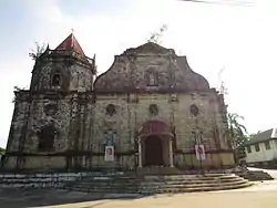 Facade of the Saint John the Baptist Parish Church in Dingle | |
 Seal | |
| Nickname(s): Spelunker's Paradise | |
Anthem:
| |
 Map of Iloilo with Dingle highlighted | |
OpenStreetMap 
| |
.svg.png.webp) Dingle Location within the Philippines | |
| Coordinates: 11°03′N 122°40′E | |
| Country | |
| Region | Western Visayas (Region VI) |
| Province | Iloilo |
| District | 4th District |
| Founded | 1593 |
| Established | 1823 |
| Chartered | 1907 |
| Barangays | 33 (see Barangays) |
| Government | |
| • Type | Sangguniang Bayan |
| • Mayor | Rufino P. Palabrica III |
| • Vice Mayor | Quindialem D. Villanueva |
| • Representative | Braeden John Q. Biron |
| • Electorate | 27,376 voters (2019) |
| Area | |
| • Total | 98.37 km2 (37.98 sq mi) |
| Elevation | 56 m (184 ft) |
| Population | |
| • Total | 45,335 |
| • Density | 460/km2 (1,200/sq mi) |
| • Households | 10,365 |
| Economy | |
| • Income class | 3rd municipal income class |
| • Poverty incidence | 21.79% (2015)[4] |
| • Revenue | ₱123,694,999.35 (2016) |
| Time zone | UTC+8 (PST) |
| ZIP code | 5035 |
| PSGC | |
| IDD : area code | +63 (0)33 |
| Climate type | tropical climate |
| Native languages | Kinaray-a Hiligaynon Tagalog |
| Website | www |
The town is known for its baroque-architecture church and its archaeological cave sites, such as the Lapuz Lapuz Cave, famous for revealing hunter-gatherer lives of the ancient people of Panay.
History
Dingle started as a pre-colonial settlement of Sumandig, which was under the jurisdiction of Simsiman, a pueblo of Laglag.[5] The settlement was also known as Sibucao, Ba-ong, and Orvat. The Augustinian priest, Fr. Francisco Manuel Blanco, first founded Dingle as a visita of Pototan in 1593. Dingle became independent on April 23, 1611. In 1629 however, it was annexed to Dumangas, Iloilo and to Dueñas, Iloilo in 1641 (until 1825). On August 16, 1850, by order of Governor General of the Philippines Antonio de Urbiztondo, Dingle again became independent and was officially named the town of Dingle. The first town head was Julio Dator (1823–1827). In 1865, Fr. Fernando Llorente ordered the construction of the Dingle Catholic Church which was completed in 1886.
During the second phase Philippine Revolution against Spain, during the Spanish–American War, Dingle staged the first armed uprising in the Province of Iloilo. Now known as the "Cry of Lincud", the revolt occurred in Barrio Lincud on October 28, 1898. Today the event is commemorated as a special non-working holiday.[6][7] The leaders of the uprising were Adriano Hernández, Julio Hernández, and Nicolas Roces. Adriano Hernández later became a brigadier general in the Philippine Revolutionary Army. He then represented the province at the Malolos Congress. Later, he was appointed Director of the Bureau of Agriculture. Today, his statue stands inside the Philippine Army's Camp General Adriano D. Hernandez in Dingle, which is named in his honor.
Under the Americans, Dingle was annexed to Pototan, Iloilo, the latter being larger and more prosperous. Nonetheless, through the efforts of Gen. Adriano Hernandez, the separation of the town from Pototan was given impetus in 1907.
In 1954, the sitio of Nazuni was converted into a barrio and was added as a barangay of Dingle.[8]
Geography
The topography of Dingle is relatively rolling hills and narrow plains from the Poblacion. The flat lands extend along the Jalaur River through its borderline to the southeast. This starts to roll upward from the Poblacion going to the north-west. From the west of the Poblacion rises the slopes, steep and mountainous. This indicates that the topography of Dingle meets a certain type-cropping pattern.
Dingle is 38 kilometres (24 mi) from Iloilo City.
Climate
| Climate data for Dingle, Iloilo | |||||||||||||
|---|---|---|---|---|---|---|---|---|---|---|---|---|---|
| Month | Jan | Feb | Mar | Apr | May | Jun | Jul | Aug | Sep | Oct | Nov | Dec | Year |
| Average high °C (°F) | 28 (82) |
29 (84) |
30 (86) |
32 (90) |
32 (90) |
30 (86) |
29 (84) |
29 (84) |
29 (84) |
29 (84) |
29 (84) |
28 (82) |
30 (85) |
| Average low °C (°F) | 23 (73) |
22 (72) |
23 (73) |
23 (73) |
25 (77) |
25 (77) |
24 (75) |
24 (75) |
24 (75) |
24 (75) |
23 (73) |
23 (73) |
24 (74) |
| Average precipitation mm (inches) | 57 (2.2) |
37 (1.5) |
41 (1.6) |
42 (1.7) |
98 (3.9) |
155 (6.1) |
187 (7.4) |
162 (6.4) |
179 (7.0) |
188 (7.4) |
114 (4.5) |
78 (3.1) |
1,338 (52.8) |
| Average rainy days | 12.0 | 7.7 | 9.2 | 10.2 | 19.5 | 24.6 | 26.9 | 25.1 | 25.5 | 25.2 | 18.0 | 13.0 | 216.9 |
| Source: Meteoblue [9] | |||||||||||||
Barangays
Dingle is politically subdivided into 33 barangays.
- Abangay
- Agsalanan
- Agtatacay
- Alegria
- Bongloy
- Buenavista
- Caguyuman
- Calicuang
- Camambugan
- Dawis
- Ginalinan Nuevo
- Ginalinan Viejo
- Gutao
- Ilajas
- Libo-o
- Licu-an
- Lincud
- Matangharon
- Moroboro
- Namatay
- Nazuni
- Pandan
- Poblacion
- Potolan
- San Jose
- San Matias
- Siniba-an
- Tabugon
- Tambunac
- Tanghawan
- Tiguib
- Tinocuan
- Tulatula-an
Demographics
| Year | Pop. | ±% p.a. |
|---|---|---|
| 1903 | 12,129 | — |
| 1918 | 13,333 | +0.63% |
| 1939 | 16,698 | +1.08% |
| 1948 | 18,475 | +1.13% |
| 1960 | 19,748 | +0.56% |
| 1970 | 23,375 | +1.70% |
| 1975 | 26,368 | +2.45% |
| 1980 | 29,179 | +2.05% |
| 1990 | 35,415 | +1.96% |
| 1995 | 35,639 | +0.12% |
| 2000 | 38,311 | +1.56% |
| 2007 | 40,828 | +0.88% |
| 2010 | 43,290 | +2.15% |
| 2015 | 45,335 | +0.88% |
| Source: Philippine Statistics Authority [3] [10] [11][12] | ||
In the 2015 census, the population of Dingle, Iloilo, was 45,335 people, [3] with a density of 460 inhabitants per square kilometre or 1,200 inhabitants per square mile.
Infrastructure
Power
The Panay Diesel Power Plant located at Tinocuan, Dingle provides 110 megawatts of electricity to Panay. The power plant is operated by the National Power Corporation.
Water
Two natural springs, the Lubong-Tubig and Talinab, serve as water source for the Dingle-Pototan Water District. While the Jalaur Irrigation Dam also known as Moroboro Dam, built in 1955, provides irrigation to the agricultural lands of Dingle and nearby towns.
Landmarks
Bulabog Putian National Park
Bulabog Putian is the only limestone rock formation on Panay. It was designated a National Park through Congressional Bill No. 1651, and such is considered a "nationally significant area." It occupies a land area of 834.033 hectares covering five of the 33 barangays of Dingle. The park contains 13 known caves namely : Lungib, Hapu-Hapo, Ma-arhong, Guiso, Maestranza, Linganero, Lapuz Lapuz, Ticondal, Butac, Tuco, San Roque, Pitong Liko and Nautod. The Maeztranza Cave is historically important as it served as a hide-out of the revolutionary forces during the Spanish colonial period and on its stone walls are inscriptions of the revolutionary troops.
Mt. Manyakiya
Mount Manyakiya is a natural viewing deck that provides a panoramic view of Negros Island as well as the low lying towns of the province of Iloilo. Nautod Wall, one of the major rock-climbing destination in the Philippines, can be found here.
Water
- Lake Bito
- Jalaur River
- Lubong-Tubig Spring
- Talinab Spring
Historical
- Cry of Lincud Marker
- Memorial to the Cry of Lincud Heroes
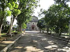
- Dingle Parish Church – Finished in 1886, this church, a fine example of Filipino baroque adaptation, is made of limestones from Bulabog Mountain, painstakingly carried by the early parishioners through narrow, steep and dangerous trails to the present site.
Other landmarks
- Hanging Bridge is a ruined post-WWII bridge that traverses the Jalaur River.
- Camp Pasica is a 13-hectare Girl Scout Camp.
- Camp Hernandez is a 37-hectare military training camp of the Armed Forces of the Philippines named in honor of the revolutionary hero, Gen. Adriano D. Hernández.
- Museo de Dingle
Culture
Festivals
The Dingle Town Fiesta is celebrated every 24th day of June in honor of its patron saint, John the Baptist.
The Pagdihon Festival is a celebration in commemoration of the Cry of Lincud, the first revolt against the Spaniards on Panay. It is held every 4th week of October.
List of Town Executives
Gobernadorcillos
| Order | Name | Years in Office |
|---|---|---|
| 1 | Julio Dator | 1823-1827 |
| 2 | Buenaventura Osano | 1827-1829 |
| 3 | Marcelino Dayot | 1829-1835 |
| 4 | Magdaleno Muyco | 1835-1843 |
| 5 | Buenaventura Osano | 1843-1845 |
| 6 | Alejandro Daraug | 1845-1851 |
| 7 | Magdaleno Muyco | 1851-1853 |
| 8 | Luís Cantalicio Dayot | 1853-1861 |
| 9 | Alejandro Daraug | 1863-1865 |
| 10 | Domingo Osano | 1865-1869 |
| 11 | Luís Cantalicio Dayot | 1869-1873 |
| 12 | Santiago Sanico | 1873-1879 |
| 13 | Tomás Sanico | 1879-1885 |
| 14 | Santiago Sanico | 1885-1887 |
| 15 | Julián Dalipe | 1887-1893 |
Capitán municipal
In 1893, the Maura Law was passed to reorganize town governments with the aim of making them more effective and autonomous. The law changed the title of chief executive of the town from gobernadorcillo to capitán municipal.[13]
| Order | Name | Years in Office |
|---|---|---|
| 16 | Gabriel Sinoy | 1894-1898 |
Capitán del barrio
Dingle was reduced to the status of barrio from 1903-1908 after it was merged with the Municipality of Pototan by virtue of Act No. 719.[14]
| Order | Name | Years in Office |
|---|---|---|
| Nicolás Roces |
Presidentes municipal
The Municipality of Dingle was re-established in 1908 after Iloilo 4th District Assemblyman Adriano Hernández succeeded in persuading Governor-General James Francis Smith to issue an executive order separating Dingle from Pototan.[15]
| Order | Name | Portrait | Years in Office |
|---|---|---|---|
| 1908-1912 | |||
| Tomás Sanico | 1912-1915 | ||
| Vicente Dayot |  |
1915-1918 | |
| Dayot | 1918-1925 | ||
| Luís Dayot |  |
1925-1928 | |
| Cipriano Montero, Sr. | 1928-1931 | ||
| Julio D. Muyco | 1931-1937 | ||
| Cristino Abelardo M. Aportadera | 1937-1940 |
Municipal Mayors
| Order | Name | Portrait | Years in Office |
|---|---|---|---|
| Julio D. Muyco | 1940-1946 | ||
| Julián Masna | 1946-1947 | ||
| Alfonso M. Espino |  |
1947-1957 | |
| Numeriano D. Dator | 1957-1959 | ||
| Leonardo M. Aportadera | 1959-1963 | ||
| Rufino Palabrica, Jr. |  |
1963-1967 | |
| Roberto Palabrica, Sr. |  |
1968-1986 | |
| José Aportadera |  |
1986-1988 | |
| Teodoro Luntao, Jr. | 1988-1992 | ||
| Henry Anotado | 1992-2001 | ||
| Robin Solinap | 2001-2007 | ||
| Rufino Palabrica, III | 2007-2016 | ||
| Jessie Alecto | 2016-2018 | ||
| Rufino Palabrica, III | 2018–present |
Notable People
- General Adriano D. Hernández – Revolutionary Hero
- Nancy Deaño – Olympic competitor
- Most Rev. Jose S. Palma, D.D., S.Th.D – current Archbishop of Cebu and former president of the Catholic Bishops' Conference of the Philippines.
- Guillermo Gómez Rivera – Filipino writer, journalist, poet, playwright, historian, linguist
- Merlie M. Alunan – Palanca Awardee for Literature
References
- Municipality of Dingle | (DILG)
- "Province: Iloilo". PSGC Interactive. Quezon City, Philippines: Philippine Statistics Authority. Retrieved 12 November 2016.
- Census of Population (2015). "Region VI (Western Visayas)". Total Population by Province, City, Municipality and Barangay. PSA. Retrieved 20 June 2016.
- "PSA releases the 2015 Municipal and City Level Poverty Estimates". Quezon City, Philippines. Retrieved 12 October 2019.
- Dueñas.http://vicilongo.weebly.com/iloilo-history-part-1.html
- "House of Representatives, H. No. 5650" (pdf). Retrieved 2012-11-21.
- "Proclamation No. 253 by the President of the Philippines" (PDF). Archived from the original (pdf) on 2013-08-25. Retrieved 2012-11-21.
- "An Act Creating the Barrio of Nasumi in the Municipality of Dingle, Province of Iloilo". LawPH.com. Archived from the original on 2012-07-10. Retrieved 2011-04-09.
- "Dingle: Average Temperatures and Rainfall". Meteoblue. Retrieved 3 May 2020.
- Census of Population and Housing (2010). "Region VI (Western Visayas)". Total Population by Province, City, Municipality and Barangay. NSO. Retrieved 29 June 2016.
- Censuses of Population (1903–2007). "Region VI (Western Visayas)". Table 1. Population Enumerated in Various Censuses by Province/Highly Urbanized City: 1903 to 2007. NSO.
- "Province of Iloilo". Municipality Population Data. Local Water Utilities Administration Research Division. Retrieved 17 December 2016.
- Laurel, José (1926). Local government in the Philippine Islands. Manila: La Pilarica Press. pp. 30, 36–37.
- "Act No. 719, April 04, 1903". Supreme Court E-Library. Retrieved 7 August 2020.
- Sonza, Demy (2001). Adriano Hernandez: A Hero in War and in Peace. Iloilo City: Local History and Biography Foundation. p. 173.
External links
- Dingle Profile at PhilAtlas.com
- Philippine Standard Geographic Code
- Philippine Census Information
- Local Governance Performance Management System
Places adjacent to Dingle, Iloilo | ||||||||||
|---|---|---|---|---|---|---|---|---|---|---|
| ||||||||||
Iloilo City (capital) | |
| Municipalities |
|
| Component city | |
| Highly urbanized city |
|