Divide, Colorado
Divide is an unincorporated town, a post office, and a census-designated place (CDP) located in Teller County, Colorado, United States. The Divide post office has the ZIP Code 80814.[4] At the United States Census 2010, the population of the Divide CDP was 127, while the population of the 80814 ZIP Code Tabulation Area was 4,023 including adjacent areas.[5] Teller County governs the unincorporated town.
Divide, Colorado | |
|---|---|
 Divide from Ute Pass. | |
| Motto(s): Center of the Known Universe[1] | |
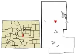 Location of the Divide CDP in Teller County, Colorado. | |
 Divide Location of the Divide CDP in the United States. | |
| Coordinates: 38°56′42″N 105°09′43″W[2] | |
| Country | |
| State | |
| County | Teller County |
| Government | |
| • Type | unincorporated town |
| Area | |
| • Total | 0.336 sq mi (0.869 km2) |
| • Land | 0.336 sq mi (0.869 km2) |
| • Water | 0.000 sq mi (0.000 km2) |
| Elevation | 9,117 ft (2,779 m) |
| Population (2010) | |
| • Total | 127 |
| • Density | 378/sq mi (146/km2) |
| Time zone | UTC-7 (MST) |
| • Summer (DST) | UTC-6 (MDT) |
| ZIP Code[4] | 80814 |
| Area code(s) | 719 |
| GNIS feature[3] | Divide CDP |
Travelers will find easy access to fuel and convenience-store items, several restaurants, a grocery, post office, a trading post & gift shop, and a local brewery. Located just a few miles outside of Divide is Rocky Mountain Mennonite Camp, a Christian youth and young adult camp, and Mueller State Park is just six minutes south of town, offering camping, hiking, fishing and other outdoor activities within its over 5,000 acres of spring-fed meadows, ponds, forested ridges, and massive rocks. For those with pets or horses, Divide Feed Store provides staples and supplies of all types. Divide is home to Summit Elementary and a number of churches, as well as the Teller County Sheriff's office. The Teller County Jail behind the Sheriff's office is infamous for holding the 'Texas Seven' back in early 2001. Teller County Regional Animal Shelter is nearby, as well.
Divide is a growing, planned community. Divide is planned in three areas: the town center, rural residential land parcels, and larger rural land parcels.
History
The Divide Post Office has been in operation since 1889.[6] The town was named for Ute Pass between the Arkansas River watershed and the Missouri River watershed.[7][8]
Geography
Divide sits on the north slope of Pikes Peak. Ute Pass is immediately west of town. Divide is located at the western intersection of U.S. Highway 24 and State Highway 67 (The highways overlap east to Woodland Park).
The Divide CDP has an area of 215 acres (0.869 km2), all land.[2]
Demographics
The United States Census Bureau initially defined the Divide CDP for the United States Census 2010.
| Year | Pop. | ±% |
|---|---|---|
| 2010 | 127 | — |
| 2020 | — | |
| Source: United States Census Bureau | ||
See also
- Outline of Colorado
- State of Colorado
- Colorado cities and towns
- Colorado counties
- Colorado metropolitan areas
References
- Navarr, Linda (September 20, 2015). "Cripple Creek/Divide/Florissant". Gazette.
- "State of Colorado Census Designated Places - BAS20 - Data as of January 1, 2020". United States Census Bureau. Retrieved December 27, 2020.
- "U.S. Board on Geographic Names: Domestic Names". United States Geological Survey. Retrieved December 27, 2020.
- "Look Up a ZIP Code". United States Postal Service. Retrieved December 27, 2020.
- "2010: DEC Summary File 1". United States Census Bureau. Retrieved December 27, 2020.
- "Post offices". Jim Forte Postal History. Archived from the original on 6 March 2016. Retrieved 25 June 2016.
- Dawson, John Frank. Place names in Colorado: why 700 communities were so named, 150 of Spanish or Indian origin. Denver, CO: The J. Frank Dawson Publishing Co. p. 18.
- Dodd, Beth. "Center of the Known Universe, Divide, CO". Woodland Park, Colorado: The High Country Messenger.
External links
- Divide @ Colorado.com
- Divide @ UncoverColorado.com
- Divide @ TellerLinks.com
- Divide Chamber of Commerce
- Divide Fire Protection District
- Teller County website
Municipalities and communities of Teller County, Colorado, United States | ||
|---|---|---|
| Cities | 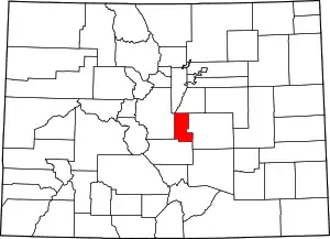 Map of Colorado highlighting Teller County | |
| Town | ||
| CDPs | ||
| Unincorporated community | ||
| Ghost towns | ||
| Footnotes | ‡This populated place also has portions in an adjacent county or counties | |
| ||