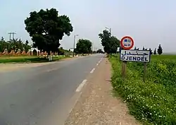
Djendel
Djendel (formerly Lavigerie during the period of French colonization) is a commune in the Aïn Defla wilaya in northern Algeria, located 110 km southwest of Algiers, 40 km east of Aïn Defla, and 30 km southwest of Médéa.
Djendel
Arabic: جندل Berber: ⴵⴻⵏⴷⴻⵍ | |
|---|---|
 The boundary of Djendel | |
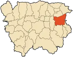 Djendel's location within Aïn Defla Province | |
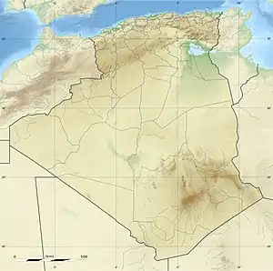 Djendel Djendel's location within Algeria | |
| Coordinates: 36°13′07″N 2°24′32″E | |
| Country | Algeria |
| Province | Aïn Defla |
| Area | |
| • Total | 251.0 km2 (96.91 sq mi) |
| Population (2008) | |
| • Total | 30,170 |
| • Density | 120/km2 (300/sq mi) |
| Time zone | UTC+1 (West Africa Time) |
Geography
Neighboring Communes of Djendel | ||||||||||
|---|---|---|---|---|---|---|---|---|---|---|
| ||||||||||

History
Formerly a mixed commune (commune mixte[fr] - an area where Europeans were present though in very small numbers) in the Algiers département of French Algeria,[1] created on August 25, 1880, Djendel incorporated the douars (tribal territories) of Djendel, Ghribs, and Oued-Telbenet.[2]
On December 16, 1905, Djendel absorbed some of the dissolved mixed commune of Hammam Righa.[3] In 1956, it was promoted by decree from a mixed commune to a commune according to the Law of 1884 and was absorbed into the département of Orléansville.[4] The commune maintained its municipal status during the restructuring of 1963, absorbing the former communes of Aïn Lechiekh and Oued Djemaâ (October 1963 for the latter).
In 1893, during the colonization period, the city was named Lavigerie[2] in honor of Charles Martial Allemand Lavigerie. After independence, the commune was renamed Djendel by decree no. 65-246[fr] of September 30, 1965.
Demographics
- Area: 251 km2
- Population: 30,170 (2008)[5]
- Evolution of the population:
- 16,361 in 1876
- 18,884 in 1881
- 26,851 in 1901
- 34,170 (including 1,154 Europeans) in 1906
- 6,368 in 1958
- 8,773 in 1960
- 24,924 in 1966
- 26,849 in 1998
Economy
The region is agricultural, and includes the Ghrib Dam.
References
- "Recherche géographique: Algérie". Archives Nationales d'Outre-Mer. Retrieved 2020-05-04.
- "Recherche géographique: Djendel, Commune Mixte (Algérie)". Archives Nationales d'Outre-Mer. Retrieved 2020-05-04.
- "Recherche géographique: Hammam Righa, Commune Mixte (Algérie)". Archives Nationales d'Outre-Mer. Retrieved 2020-05-04.
- "Recherche géographique: Lavigerie (Algérie)". Archives Nationales d'Outre-Mer. Retrieved 2020-05-04.
- "Djendel (Commune, Aïn Defla, Algeria) - Population Statistics, Charts, Map and Location". www.citypopulation.de. Retrieved 2020-05-04.
.svg.png.webp)