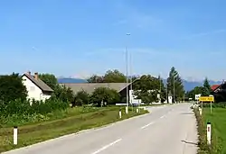
Dobro Polje, Radovljica
Dobro Polje (pronounced [ˈdɔːbɾɔ ˈpoːljɛ], German: Gutenfeld[2]) is a settlement on the left bank of the Sava River in the Municipality of Radovljica in the Upper Carniola region of Slovenia.
Dobro Polje | |
|---|---|
 | |
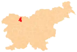
 Dobro Polje Location in Slovenia | |
| Coordinates: 46°19′23.09″N 14°13′24.27″E | |
| Country | |
| Traditional region | Upper Carniola |
| Statistical region | Upper Carniola |
| Municipality | Radovljica |
| Elevation | 463.1 m (1,519.4 ft) |
| Population (2002) | |
| • Total | 119 |
| [1] | |
Geography

Malo Dobro Polje
Dobro Polje is divided into the hamlet of Malo Dobro Polje (literally, 'little Dobro Polje'; German: Kleingutenfeld) to the southeast and the main settlement of Veliko Dobro Polje (literally, 'big Dobro Polje'; German: Großgutenfeld) to the northwest.[2][3][4][5] It is located in the lower part of the Brezje Basin. The soil is thin and sandy, limiting agriculture. Peračica Creek, a tributary of the Sava River, flows through a deep bed east of the village.[3]
References
- Statistical Office of the Republic of Slovenia
- Leksikon občin kraljestev in dežel zastopanih v državnem zboru, vol. 6: Kranjsko. Vienna: C. Kr. Dvorna in Državna Tiskarna. 1906. p. 148.
- Savnik, Roman (1968). Krajevni leksikon Slovenije, vol. 1. Ljubljana: Državna založba Slovenije. p. 280.
- Zupan, Ciril (May 19, 2015). "Vas Dobro Polje". Gorenjski glas. Retrieved August 11, 2019.
- Lavrenčak, Goran (2018). Dobro polje – od prve omembe do leta 1900 (PDF). Retrieved August 11, 2019.
External links
 Media related to Globoko at Wikimedia Commons
- Dobro Polje at Geopedia
| Settlements | Administrative centre: Radovljica
|  |
|---|---|---|
| Landmarks |
| |
| Notable people |
| |
This article is issued from Wikipedia. The text is licensed under Creative Commons - Attribution - Sharealike. Additional terms may apply for the media files.