Doll, Highland
Doll is a scattered mixed crofting township and rural village 2 miles (3 km) southwest of Brora, on the A9 coast road, on the east coast of Sutherland, Scottish Highlands and is in the Scottish council area of Highland. The main road artery of the A9 has bypassed Doll to the south.
Doll
| |
|---|---|
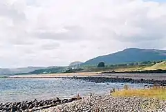 Looking south from Brora towards Doll. | |
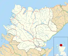 Doll Location within the Sutherland area | |
| OS grid reference | NC888029 |
| Council area | |
| Country | Scotland |
| Sovereign state | United Kingdom |
| Post town | Brora |
| Postcode district | KW9 6 |
| Police | Scotland |
| Fire | Scottish |
| Ambulance | Scottish |
Etymology
The name Doll may be of Brittonic origin and derived from dol meaning "haugh, meadow" (c.f. Welsh dôl; compare Dull).[1]
Settlements
Doll, in the Parish of Clyne, is a scattered crofting township, located south of the Brora River with Brora located at the other side river to the northeast. Doll consists of a large flat plain, in a triangular shape, with the longest edge following the course of the river. To the southwest lies the village of Golspie. John Bartholomew described the hamlet as:
- Doll, hamlet with school, Clyne par., SE. Sutherlandshire, 2 miles W. of Brora.[2]
References
- Watson, W.J.; Taylor, Simon (2011). The Celtic Place-Names of Scotland (reprint ed.). Birlinn LTD. ISBN 9781906566357.
- "History of Doll, in Highland and Sutherland Map and description, A Vision of Britain through Time". Vision of Britain. GB Historical GIS - University of Portsmouth. Retrieved 14 February 2018.