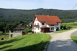
Dolnji Kot
Dolnji Kot (pronounced [ˈdoːlnji ˈkoːt], German: Unterwinkel[2]) is a settlement on the left bank of the Krka River in the Municipality of Žužemberk in southeastern Slovenia. The area is part of the historical region of Lower Carniola. The municipality is now included in the Southeast Slovenia Statistical Region.[3]
Dolnji Kot | |
|---|---|
 | |
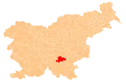
 Dolnji Kot Location in Slovenia | |
| Coordinates: 45°47′35.6″N 14°58′39.84″E | |
| Country | |
| Traditional region | Lower Carniola |
| Statistical region | Southeast Slovenia |
| Municipality | Žužemberk |
| Area | |
| • Total | 1.98 km2 (0.76 sq mi) |
| Elevation | 203.7 m (668.3 ft) |
| Population (2002) | |
| • Total | 37 |
| [1] | |
A roadside chapel-shrine in the northern part of the settlement was built in 1898.[4]
References
- Statistical Office of the Republic of Slovenia
- Leksikon občin kraljestev in dežel zastopanih v državnem zboru, vol. 6: Kranjsko. Vienna: C. Kr. Dvorna in Državna Tiskarna. 1906. p. 172.
- Žužemberk municipal site
- "EŠD 13869". Registry of Immovable Cultural Heritage (in Slovenian). Ministry of Culture of the Republic of Slovenia. Retrieved 24 March 2011.
External links
 Media related to Dolnji Kot at Wikimedia Commons
- Dolnji Kot at Geopedia
| Settlements | Administrative centre: Žužemberk
|  |
|---|---|---|
| Landmarks | ||
| Notable people | ||
This article is issued from Wikipedia. The text is licensed under Creative Commons - Attribution - Sharealike. Additional terms may apply for the media files.