Dolo (river)
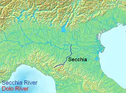
The Dolo is a mountain stream that rises on the slopes of Mount Cusna in the Reggio-Emilia province, of the Tuscany-Emilia Romagna Apennine Mountains. It is a tributary of the Secchia, and its length is about 21 to 26 kilometres (13 to 16 mi). The Dolo acts as a natural boundary between the provinces of Reggio Emilia and Modena.
| Dolo | |
|---|---|
 | |
| Location | |
| Country | Italy |
| Physical characteristics | |
| Source | |
| • location | Tuscan-Emilian Apennines, Mount Cusna |
| • coordinates | 44°14′24.21″N 10°27′22.31″E |
| • elevation | about 1,868 m (6,129 ft) |
| Mouth | |
• location | Secchia, North of Polinago |
• coordinates | 44°24′24.97″N 10°37′18.80″E |
| Length | 26 km (16 mi) |
| Basin features | |
| Progression | Secchia→ Po→ Adriatic Sea |
About 5 kilometres (3 mi) before entering the Secchia river, the Dragone mountain stream flows into the Dolo.
At the height of Fontanaluccia there is a dam (44°16′39.72″N 10°30′47.95″E) that provides water for a hydroelectric power plant (44°21′42.48″N 10°34′53.35″E) located 14 kilometres (9 mi) downstream in Farneta.
| Wikimedia Commons has media related to Dolo River. |
This article is issued from Wikipedia. The text is licensed under Creative Commons - Attribution - Sharealike. Additional terms may apply for the media files.