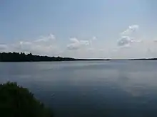
Drolet Lake
The Lake Drolet (in French: lac Drolet) is a lake located near the village of Lac-Drolet, in Le Granit Regional County Municipality, in Estrie, in Quebec, Canada. It is the source of the Drolet River, a tributary of the Chaudière River and a sub-tributary of the St. Lawrence River.
| Drolet Lake | |
|---|---|
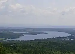 Lake Drolet seen from the site of the Maison Du Granit at an altitude of 680 meters on the eastern flank of Le Morne between Lac-Drolet and St-Sébastien. | |
 Drolet Lake | |
| Coordinates | 45.740833°N 70.86584°W |
| Primary outflows | Drolet River |
| Basin countries | Canada, Quebec, Estrie |
| Max. length | 3.2 kilometres (2.0 mi) |
| Max. width | 1.5 kilometres (0.93 mi) |
| Surface area | 2.9 kilometres (1.80 mi) |
| Average depth | 8 metres (26 ft) |
| Surface elevation | 457 metres (1,499 ft) |
Geography
Its area is 708 acres, its elevation is 457 meters, and its maximum depth is 8 meters. The species of fish are; rainbow trout, brown trout and walleye.[1] The name evokes a surveyor from Saint-Sébastien who would go fishing on the frozen lake in winter.[2] The lake is located about 2 kilometres (1.2 mi) from the Morne de Saint-Sébastien, which rises to an altitude of 820 meters.
Tourism
Located near the Route des Sommets, in an environment where nature and mountains are omnipresent, the area is ideal for hiking, camping, and outdoor activities.
Notes and references
- Wildlife service, Estrie district. Ministry of Tourism, Hunting and Fishing, Sherbrooke Quebec - card #1513.
- Commission de toponymie du Québec
External links
- "Home - Maison du Granit". Maison du Granit. Retrieved 2020-09-08.
- Association des riverains du lac Drolet