Drum (Wales)
Drum (Welsh pronunciation: [ˈdrɨm]) (Welsh: Y Drum = the ridge) is a summit in the Carneddau mountains in north Wales, 2 km north-east of Foel-fras. It is 771 m (2,526 ft) high. It is also known as Carnedd Penyborth-Goch.
| Drum (Carnedd Penyborth-Goch) | |
|---|---|
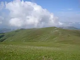 Carnedd y Ddelw (Left) and Drum (Wales) (Right) from Foel-fras. | |
| Highest point | |
| Elevation | 771 m (2,530 ft) |
| Prominence | 48 m (157 ft) |
| Listing | Hewitt, Nuttall |
| Naming | |
| English translation | ridge [1] |
| Language of name | Welsh |
| Pronunciation | Welsh: [ˈdrɨm] |
| Geography | |
| Location | Conwy / Gwynedd, Wales |
| Parent range | Snowdonia |
| OS grid | SH708695 |
| Listed summits of Drum (Wales) | ||||
| Name | Grid ref | Height | Status | |
|---|---|---|---|---|
| Carnedd y Ddelw | 686 m (2,257 ft) | Nuttall | ||
| Pen y Castell | 623 m (2,044 ft) | sub Hewitt, Nuttall | ||
Its eastern slopes are drained by the Afon Tafolog, a tributary of Afon Roe which flows through the village of Rowen before joining the River Conwy.[2]
See also
- Blue Joker, an experimental airborne early-warning radar, tested from a site high on the mountain in 1956
References
- Mark H. Nodine (2003-06-14). "Drum". Welsh-English Lexicon. Archived from the original on 2007-10-25.
- Nuttall, John & Anne (1999). The Mountains of England & Wales - Volume 1: Wales (2nd edition ed.). Milnthorpe, Cumbria: Cicerone. ISBN 1-85284-304-7.
This article is issued from Wikipedia. The text is licensed under Creative Commons - Attribution - Sharealike. Additional terms may apply for the media files.
